
CAT | Regions
27
Snowy winter on Kizhi Island
No comments · Posted by Sergei Rzhevsky in Architecture, Regions, Travel
Kizhi is an island in the northern part of Lake Onega in the south of the Republic of Karelia. It is known primarily for the exposition of the historical, architectural and ethnographic museum-reserve “Kizhi” located here, including the architectural ensemble of the Kizhi Pogost – a UNESCO World Heritage Site.
Most of the buildings are monuments of architecture, a lot of them were moved for exposition from other villages of this region. Kizhi Island on Google Maps. Photos by: Alexandr Lipilin.
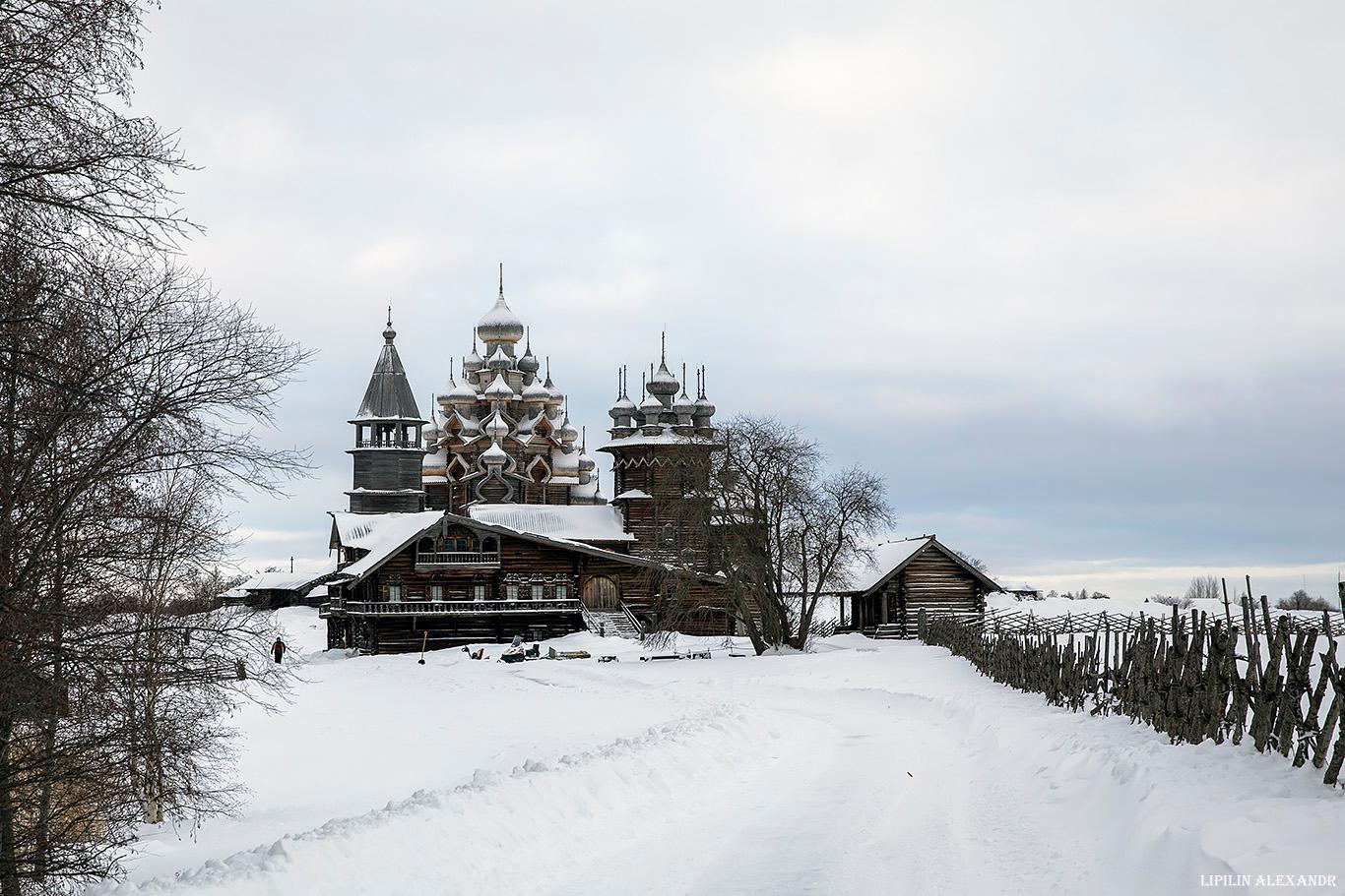
snow-covered monuments of wooden architecture

Tags: churches · Karelia Republic · Petrozavodsk city
19
Naryan-Mar – a unique regional center in the Arctic Circle
No comments · Posted by Sergei Rzhevsky in Cities, Regions, Travel
Naryan-Mar (meaning “Red town” in the Nenets language) is a town in Russia with a population of about 25 thousand people, the administrative center and the only town in the Nenets Autonomous Okrug.
It is located in the Arctic Circle, in the lower reaches of the Pechora River, 110 km from the Barents Sea. The distance from Moscow to Naryan-Mar is about 1,500 km, from Arkhangelsk – 660 km. The nearest railway station – Usinsk – is located at a distance of 350 km. Photos by: Slava Stepanov.
Tags: Naryan-Mar city · Nenets okrug
13
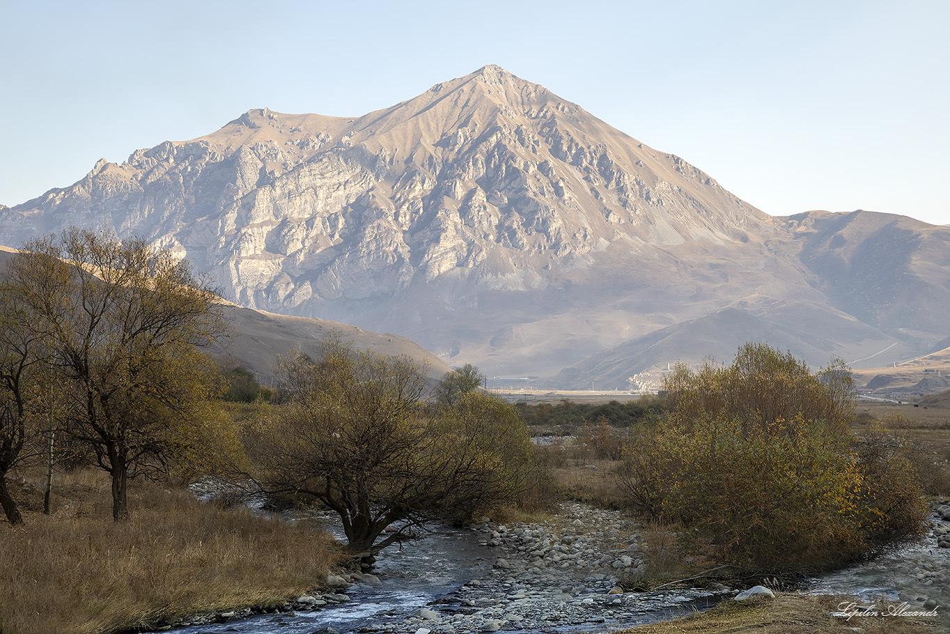
Mountain Landscapes of the Republic of North Ossetia – Alania
No comments · Posted by Sergei Rzhevsky in Regions, Travel
The Republic of North Ossetia – Alania is a federal subject of the Russian Federation located on the northern slope of the Greater Caucasus. The city of Vladikavkaz is the capital of the republic.
Foothill and mountainous areas occupy almost half of the territory of the republic, about 3,850 square kilometers. Majestic mountains covered with coniferous and deciduous forests, picturesque gorges, alpine meadows, glaciers, numerous mineral springs make a vacation in North Ossetia – Alania unforgettable. Photos by: Alexandr Lipilin.
Tags: North Ossetia Republic · Vladikavkaz city
4
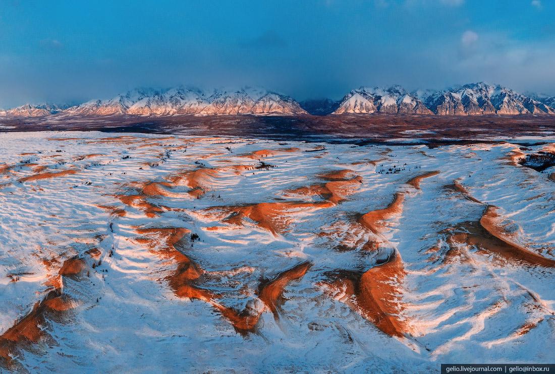
The snow-covered Chara Sands in Eastern Siberia
1 Comment · Posted by Sergei Rzhevsky in Nature, Regions, Travel
The Chara Sands is a sandy massif located in the north of Zabaykalsky Krai, a geological natural monument of federal significance. It is surrounded by larch taiga and swamps and stretches from southwest to northeast for 9 km.
Sands form ridges, dunes and chains of dunes. The length of several dunes is 150-170 m, the height – up to 80 m. The Chara Sands are outwardly similar to the deserts of Central Asia. The Chara Sands on Google Maps. Photos by: Slava Stepanov.
Tags: Chita city · Zabaikalsky krai
6
Amazing landscapes of mountainous Ingushetia
2 Comments · Posted by Sergei Rzhevsky in Nature, Regions, Travel
The Republic of Ingushetia is located on the northern slopes of the foothills of the Greater Caucasus Range (in its central part) and on the adjoining small ranges of Tersky, Sunzhensky and Skalisty.
The length of this region from north to south is 144 km, from west to east – 72 km. In the northern districts the relief is steppe, in the south – it is mountainous consisting of ridges separated by valleys and gorges. Photos by: Alexandr Lipilin.

Tags: Ingushetia Republic
26
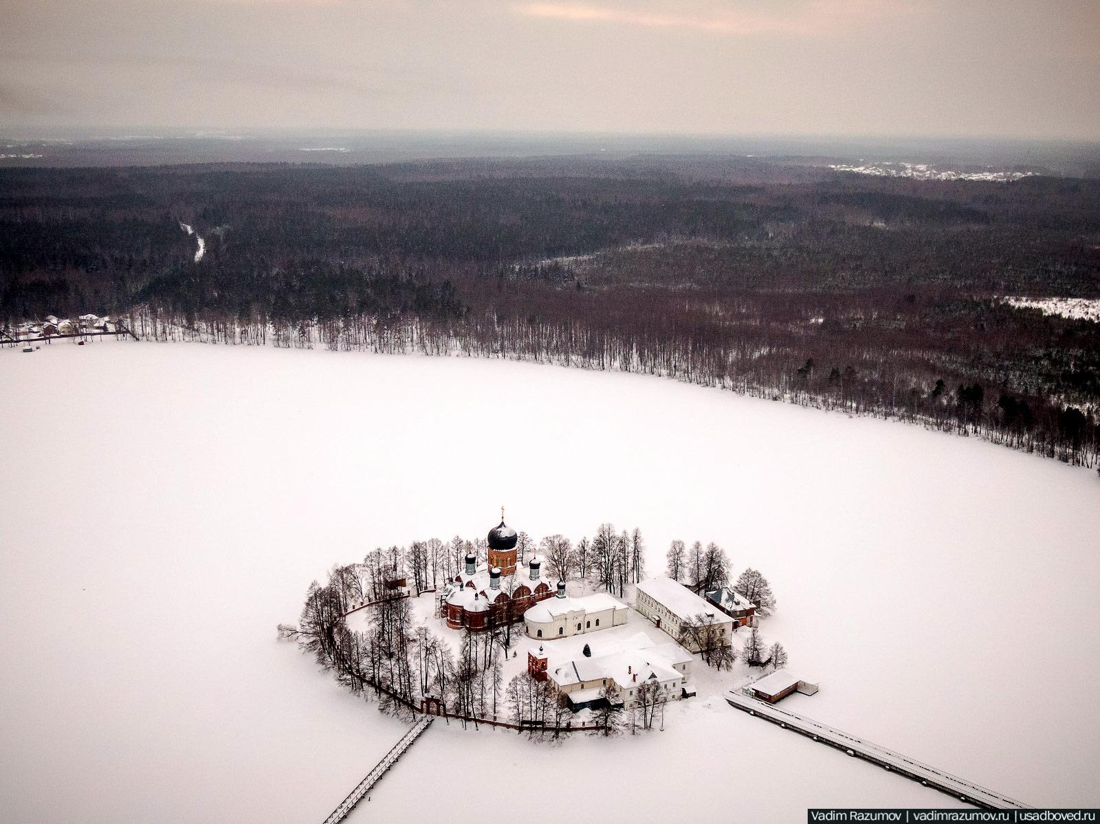
Winter in Svyato-Vvedensky Island Convent near Pokrov
No comments · Posted by Sergei Rzhevsky in Regions, Religion
The Svyato-Vvedensky Island Convent is located on an island in the middle of Lake Vvedenskoye, about 4 km from the town of Pokrov in Vladimir Oblast.
It was founded by the monks Sergius and Timothy at the very end of the 17th century. They retired to an island in the middle of the lake and built a wooden chapel and a wooden cell there. Their seclusion, according to legend, did not last long. Soon other people wishing to join them began to come here. Svyato-Vvedensky Island Convent on Google Maps. Photos by: Vadim Razumov.
Tags: churches · Vladimir oblast
18
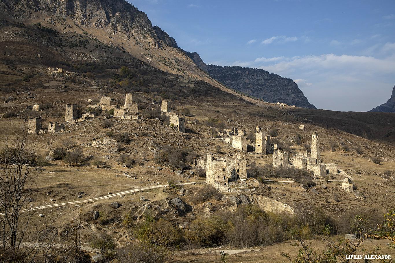
Medieval Tower Complex Egikal in Ingushetia
No comments · Posted by Sergei Rzhevsky in Regions, Travel
In the 11th-12th centuries, Egikal was one of the largest settlements of medieval Ingushetia located on the northern slopes of the foothills of the Greater Caucasus Mountain Range.
Today, on this territory there is a picturesque architectural complex “Egikal”, which includes, in addition to military and watchtowers, residential towers that belonged to old clans, as well as structures of a religious cult. Egikal on Google Maps. Photos by: Alexandr Lipilin.
Tags: Ingushetia Republic
26
Ferapontov Monastery – a unique sight of the Russian North
No comments · Posted by Sergei Rzhevsky in Architecture, Regions, Travel
The Ferapontov Belozersky Nativity Monastery is a monastery of the Vologda diocese of the Russian Orthodox Church located in the village of Ferapontovo, Vologda Oblast, about 119 km north-west of Vologda.
This is one of the oldest monasteries in the Russian North founded in the late 14th century. The monastery has survived to our time in the buildings of the 14th-17th centuries and in the wall paintings of the famous icon painter Dionysius. In 2000, this monastery was included in the UNESCO World Heritage List. Ferapontov Monastery on Google Maps. Photos by: Alexandr Lipilin.

beautiful old Russian monastery
Tags: churches · Vologda oblast
8
The Brianchaninovs’ Estate in Vologda Oblast
No comments · Posted by Sergei Rzhevsky in Architecture, History, Regions
The Brianchaninovs’ Estate is a noble estate of the early 19th century located in the village of Pokrovskoye in Vologda Oblast, about 25 km south of Vologda. Built in the style of early classicism, it is a historical and cultural monument of federal significance and a monument of landscape gardening art of regional significance.
The estate includes the main house with wings and galleries (1809-1810), the Church of the Intercession of the Most Holy Theotokos (1811), the Brianchaninovs’ necropolis (the 19th century), a park with a pond (the early 19th century), a stable (the second half of the 19th century), and a cellar (the second half of the 19th century). The Brianchaninovs’ Estate on Google Maps. Photos by: Alexandr Lipilin.

beautiful preserved noble estate
Tags: Russian Empire · Vologda oblast
3
Cape Dezhnev – the only place in Russia with the US in sight
No comments · Posted by Sergei Rzhevsky in Nature, Regions, Travel
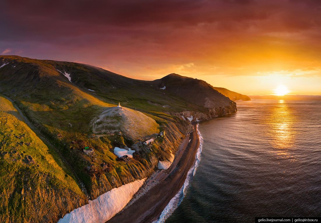
Cape Dezhnev is the extreme eastern point of the Chukotka Peninsula, mainland Russia and all of Eurasia.
It is an isolated flat-topped mountain range up to 740 m high, which drops abruptly to the sea and is located in the Bering Strait, which connects the Arctic Ocean (Chukchi Sea) with the Pacific Ocean (Bering Sea). Cape Dezhnev on Google Maps. Photos by: Slava Stepanov.
Tags: Anadyr city · Chukotka okrug