
CAT | Travel
8
Posters from Stalin’s Soviet Union Luring Foreign Tourists
2 Comments · Posted by Sergei Rzhevsky in Art, History, Travel
It is widely believed that Stalin’s Soviet Union was a country almost completely closed to foreigners. However, advertising for “Intourist” (the organization responsible for foreign tourism in the USSR), founded in the 1930s, offers a somewhat different assessment.
The country desperately needed foreign currency for industrialization, so every means possible was used to attract wealthy foreign tourists to the USSR. And this wasn’t limited to the major cities of Moscow and Leningrad.
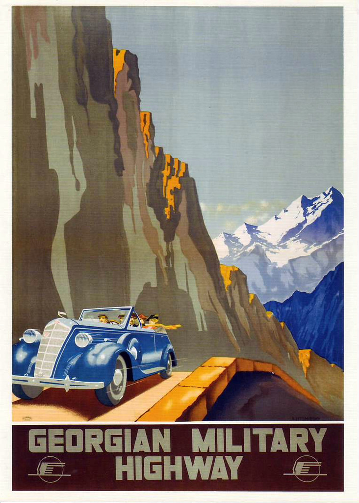

Tags: Moscow city · posters · propaganda · Saint Petersburg city · Soviet past
1
Kutkhiny Baty – Amazing Pumice Rocks in Kamchatka
No comments · Posted by Sergei Rzhevsky in Nature, Photos, Travel
Kutkhiny Baty, a bizarre curtain of pumice rocks, is a unique natural monument located approximately 4 kilometers from the source of the Ozernaya River (Kuril Lake) in Kamchatka.
According to legend, Kutkh – a powerful spirit, the creator of the world, people, and nature – lived in Kamchatka and traveled its rivers and seas. One day, he prepared to leave, and so he placed his “baty” (traditional pumice boats) on the banks of the Ozernaya River, intending to return for them later.
The legend imbues this place with sacred significance and makes it special in the eyes of the indigenous peoples of Kamchatka. “Kutkhiny Baty” can be translated as “The Boats of the God Kutkh.”
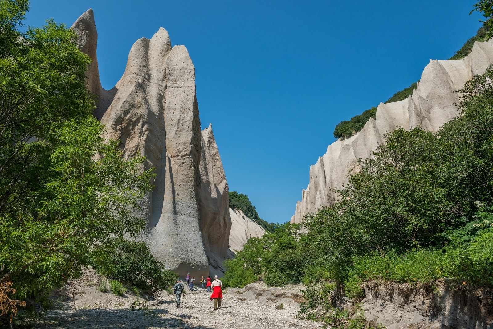
Kamchatka never ceases to amaze
Tags: Kamchatka krai · Petropavlovsk-Kamchatsky city
22
Lake Darashkol – the Hidden Treasure of Altai
No comments · Posted by Sergei Rzhevsky in Nature, Regions, Travel
Darashkol (in the Altai language “Dyarash Kol” means “beautiful lake”) is a glacial high-altitude lake (2,133 meters above sea level) located in the Altai Mountains in the southern part of the Altai Republic in Western Siberia.
The lake is situated on the territory of the Belukha Nature Park, which also includes the Kucherlinskoye and Akkemskoye lakes, and is a UNESCO World Cultural and Natural Heritage Site. Lake Darashkol on Google Maps. Photos by: Slava Stepanov.
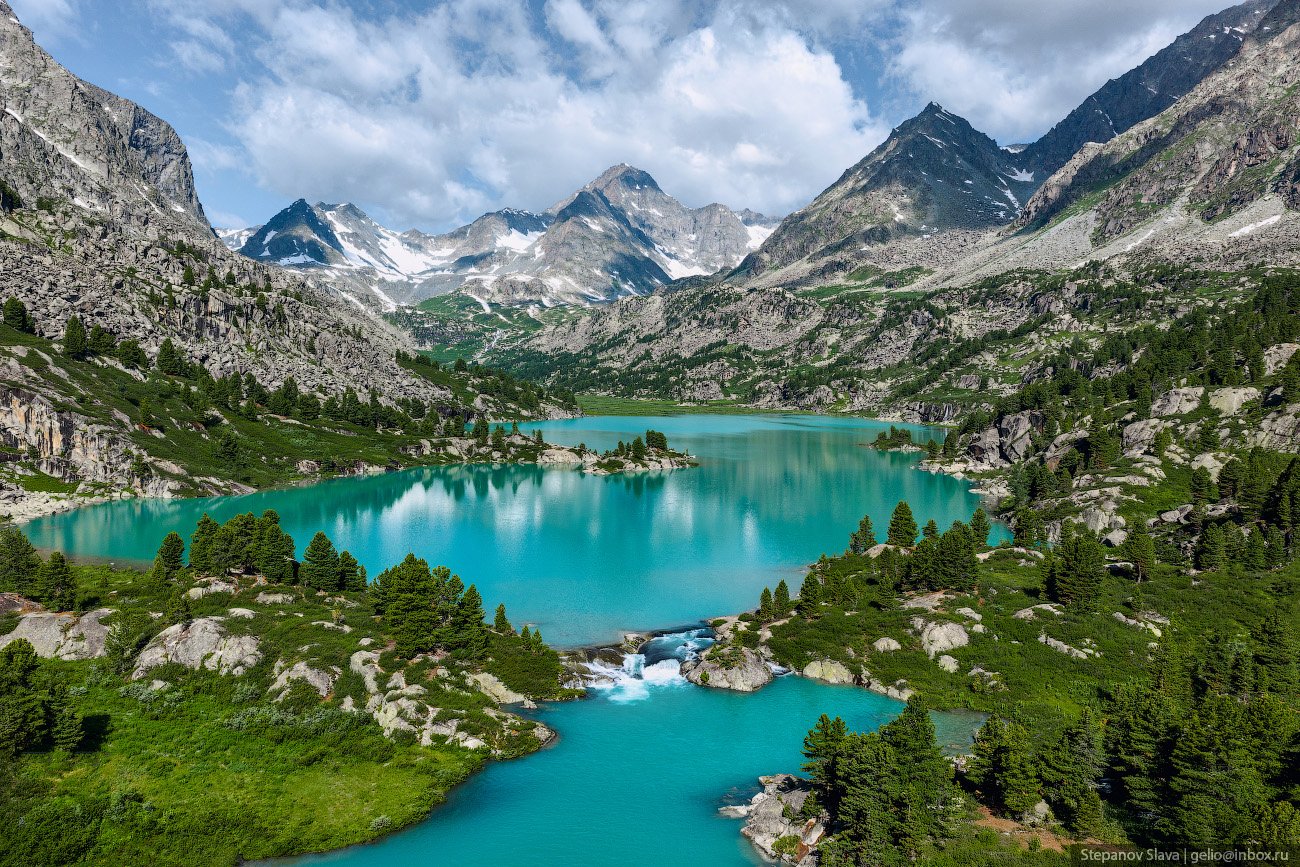
Tags: Altay Republic
18
The Beauty of Lake Baikal in Winter
No comments · Posted by Alex Smirnov in Nature, Travel, Video
It took Stas Tolstnev over two years to film this beautiful video of Lake Baikal – a tectonic lake located on the border of Irkutsk Oblast and the Republic of Buryatia in the southern part of Eastern Siberia, covering an area of 31,722 square kilometers.
It is the deepest lake on the planet, the largest natural reservoir of fresh water, and the largest freshwater lake in Eurasia by area. The lake’s width ranges from 24 to 79 km. The bottom of Lake Baikal at its deepest point is 1,187 meters below sea level.
The origin of the name is usually explained by the Turkic “Baiköl”, meaning “rich lake,” as it is particularly rich in the rare salmon species caught here. Another theory says that the name derives from the Chinese “Běihǎi”, meaning “northern sea.” Baikal is especially beautiful in winter.
Tags: Buryat Republic · Irkutsk oblast
28
The Highest Island in Russia
No comments · Posted by Sergei Rzhevsky in Nature, Regions, Travel
Atlasov Island, located 70 km south of Kamchatka, is the northernmost island of the Kuril Islands of Sakhalin Oblast. It is the surface portion of the Alaid volcano, whose eruptions led to the formation of the highest island in Russia and the 50th highest in the world.
The island is nearly round, with a diameter in the range of 13-17 km. The volcano is located exactly in the center, and the cone rises to over 2,300 meters. Rain clouds form lower down, so the summit is often hidden by clouds. Atlasov Island on Google Maps. Photos by: Slava Stepanov.

Tags: Sakhalin oblast · Yuzhno-Sakhalinsk city
22
Winter in the Museum of the Russian North “Malye Korely”
No comments · Posted by Sergei Rzhevsky in Architecture, Regions, Travel
“Malye Korely” is an open-air museum-reserve of traditional Russian wooden buildings of Arkhangelsk Oblast located in a forested area near the village of Malye Karely in the Primorsky District of Arkhangelsk Oblast, 25 km south of central Arkhangelsk, near the right bank of the Northern Dvina River.
This museum covering an area of 139.8 hectares is a popular tourist destination in the region. It is one of the largest landscape exhibitions in Russia.
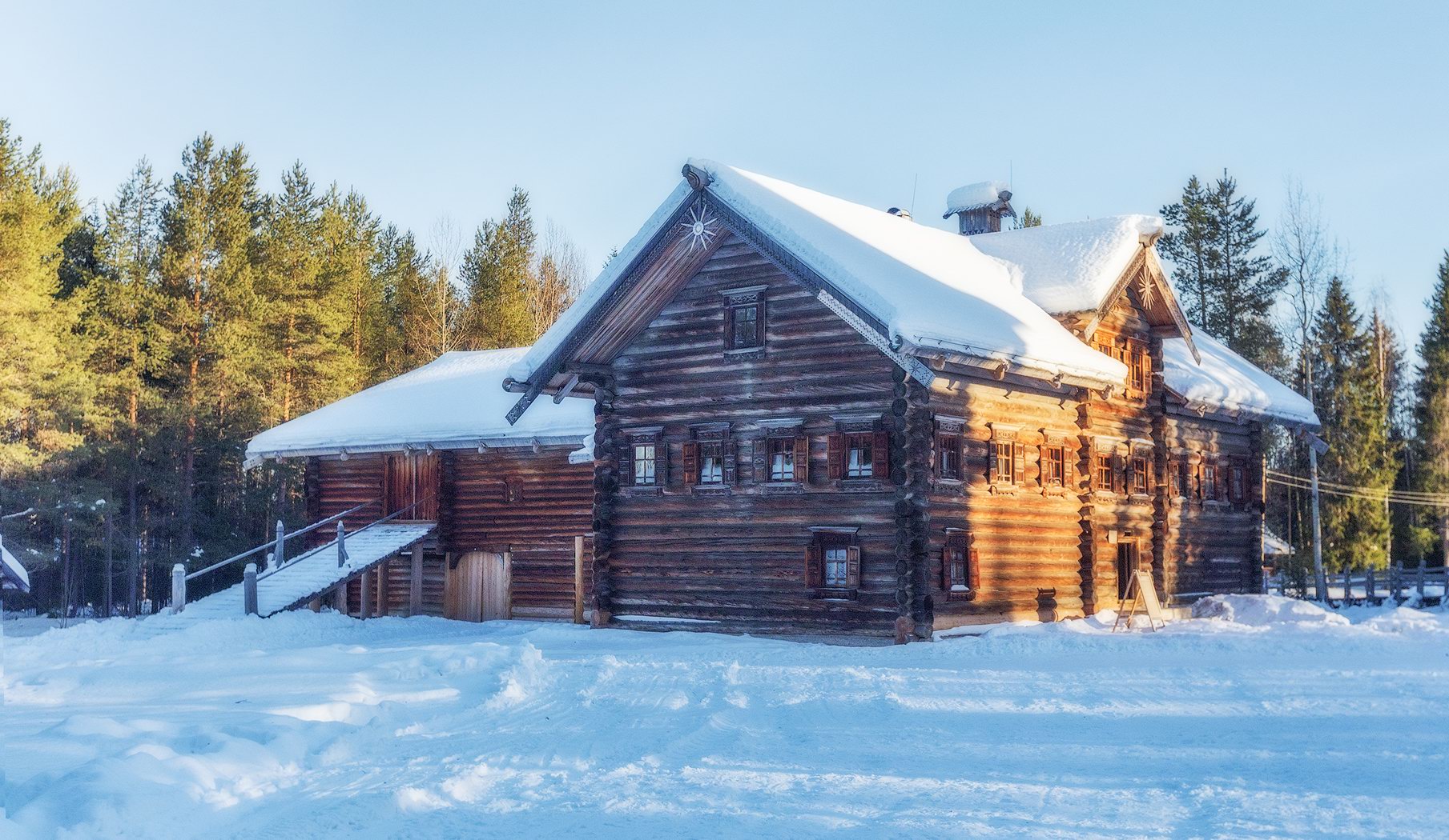
snow covered wooden architecture
Tags: Arkhangelsk oblast · museum
26
The Beauty of the Sofia Waterfalls in Karachay-Cherkessia
No comments · Posted by Sergei Rzhevsky in Nature, Regions, Travel
The Sofia Waterfalls are waterfalls of glacial origin flowing from the Sofia Glacier of Mount Sofia (3,637 meters) – one of the main natural attractions of the Arkhyz ski resort, located in the southern part of the Republic of Karachay-Cherkessia in the Western Caucasus.
These picturesque waterfalls are located approximately 15 km south of the village of Arkhyz. The Sofia Waterfalls reach their fullest flow in the height of summer (July and August), when the glacier is actively melting. The following photos were taken at the end of July by Fedor Lashkov. The Sofia Waterfalls on Google Maps.

Tags: Cherkessk city · Karachay-Cherkessia Republic · landscapes · Stavropol krai
16
The Longest Stairway in Russia
No comments · Posted by Sergei Rzhevsky in Cities, Entertainment, Travel
On the outskirts of Krasnoyarsk, you can find the longest stairway in Russia. It leads to the summit of the Torgashinsky Ridge. The stairway is 1.2 km long and consists of 1,683 steps.
The climb to the top of the ridge takes about 40 minutes, offering panoramic views of the city, the taiga, and the Krasnoyarsk Pillars. The Krasnoyarsk Stairway on Google Maps. Photos by: Slava Stepanov.

The Longest Stairway in Russia
Tags: Krasnoyarsk city
29
The Granite Kingdom of the Ulakhan-Sis Range
No comments · Posted by Sergei Rzhevsky in Nature, Regions, Travel
A lot of people know about the picturesque remnant cliffs on the Manpupuner Plateau in the Northern Urals in the Republic of Komi.
However, in Russia, there is a number of similar places and one of them is the mountain range of the Ulakhan-Sis – a geological complex located in the polar part of Yakutia between the Indigirka and Alazeya rivers. The Ulakhan-Sis on Google Maps. Photos by: Sergei Karpukhin.

Tags: Sakha Republic · Yakutsk city
19
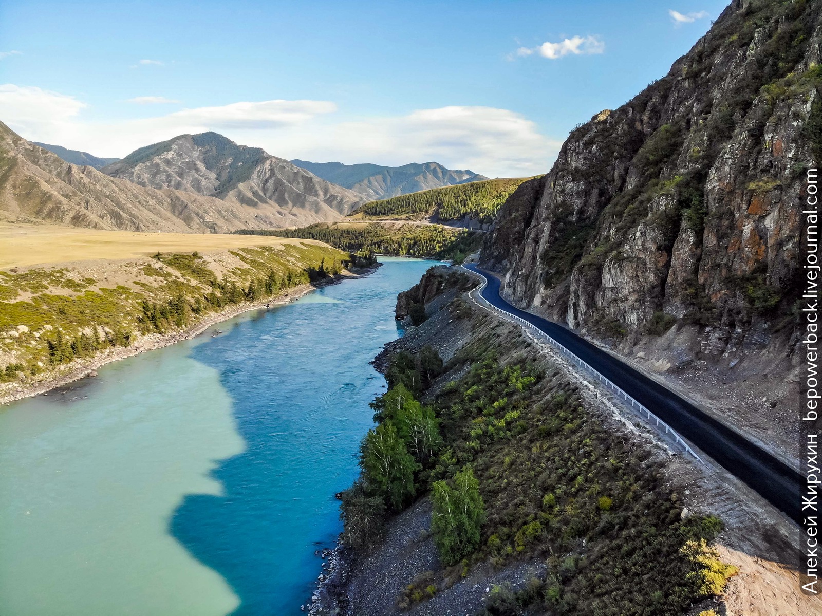
The Chuya Highway – the Most Picturesque Road in Russia
1 Comment · Posted by Sergei Rzhevsky in Photos, Regions, Travel
The federal highway R256 “Chuysky Trakt” (963 km), the oldest route from Siberia to Asia, starts in Novosibirsk and ends at the Russian border with Mongolia, passing through the territory of Novosibirsk Oblast, Altai Krai and the Altai Republic.
In 2014, National Geographic magazine included the Chuya Highway in its list of the 10 most beautiful highways in the world. Photos by: Alexey Zhirukhin.
Tags: Altai krai · Altay Republic · Biysk city · Novosibirsk oblast