
TAG | Dagestan Republic
12
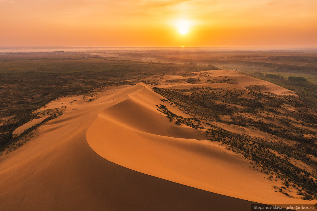
Sarykum – the Largest Sand Dune in Europe
No comments · Posted by Sergei Rzhevsky in Nature, Regions, Travel
Sarykum or Sary-Kum (translated from the Kumyk language as “Yellow Sand”) is the largest sand dune in Europe, located in the central part of the Republic of Dagestan, about 18 km northwest of Makhachkala. It is one of the largest sand dunes in Eurasia, approximately 3 km long, 2 km wide and up to 262 meters high.
The dune is located in a protected area, part of the Dagestan Nature Reserve, created on January 9, 1987. In 1968, several scenes of the famous Soviet movie “White Sun of the Desert” were filmed here. The Sarykum Sand Dune on Google Maps. Photos by: Slava Stepanov.

Tags: Dagestan Republic · Makhachkala city
15
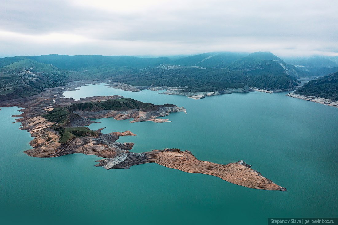
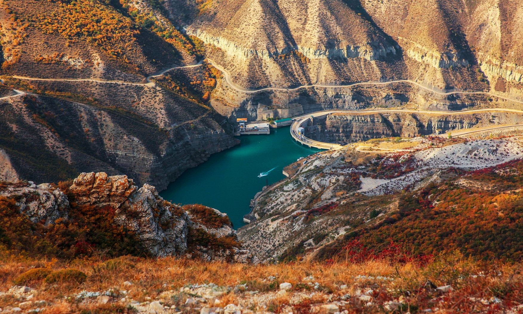
Chirkey Reservoir – the largest in the North Caucasus
No comments · Posted by Sergei Rzhevsky in Nature, Regions, Travel
Chirkey Reservoir, the largest reservoir in the North Caucasus, is located in the central part of the Republic of Dagestan. It was formed on the Sulak River as a result of the construction of the Chirkey hydroelectric power station.
The reservoir is also used for fishing and water supply. Its height above sea level is 335 m. The water surface area is 42.4 square km, the volume – 2.78 cubic km. The greatest depth is 220 m. The width of the reservoir exceeds 5 km. Chirkey Reservoir on Google Maps. Photos by: Slava Stepanov.
Tags: Dagestan Republic · Makhachkala city
22
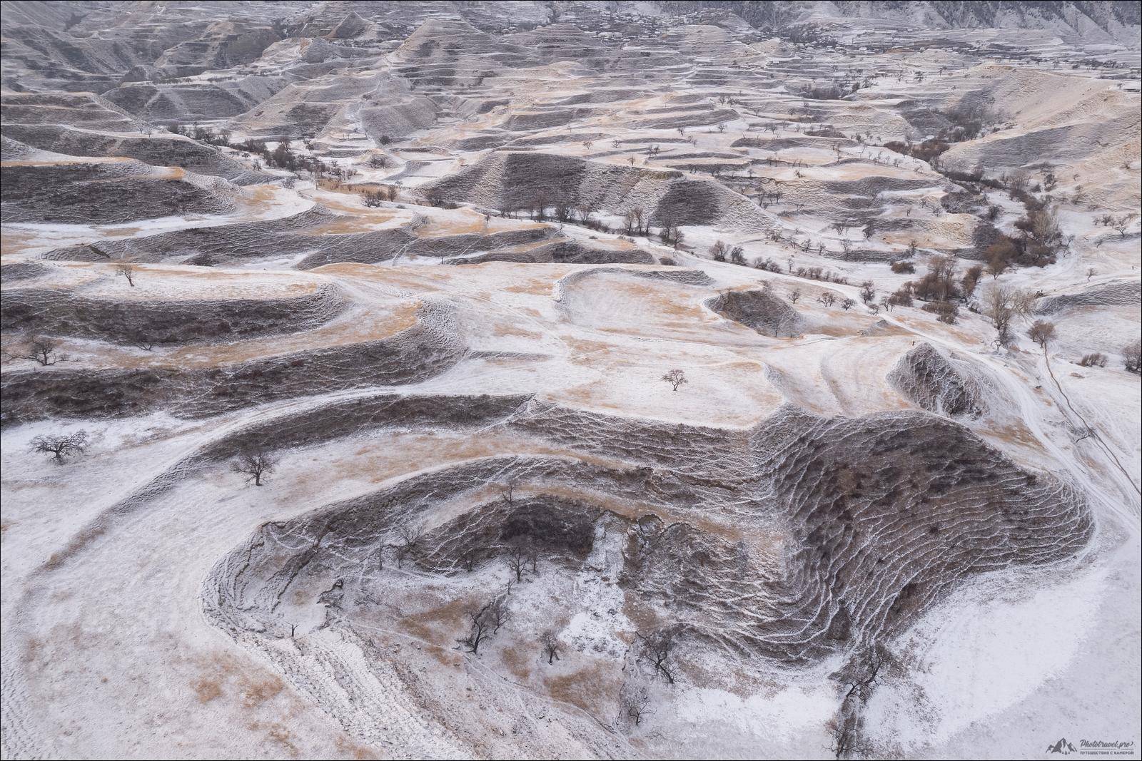
Snow-covered mountain terraces of Dagestan
No comments · Posted by Sergei Rzhevsky in Nature, Regions
The abandoned mountain terraces of Dagestan, several thousand years old, are among the most interesting sights of this region. The largest number of them has been preserved in the Gunib and Dadakhan districts.
The mountain terraces of Bali, China, Peru, and other regions of Southeast Asia and Latin America are known all over the world. In some countries, mountain terraces are UNESCO World Heritage Sites.
Tags: Abandoned · Dagestan Republic
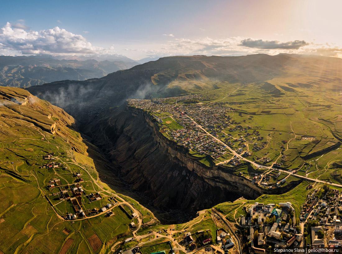
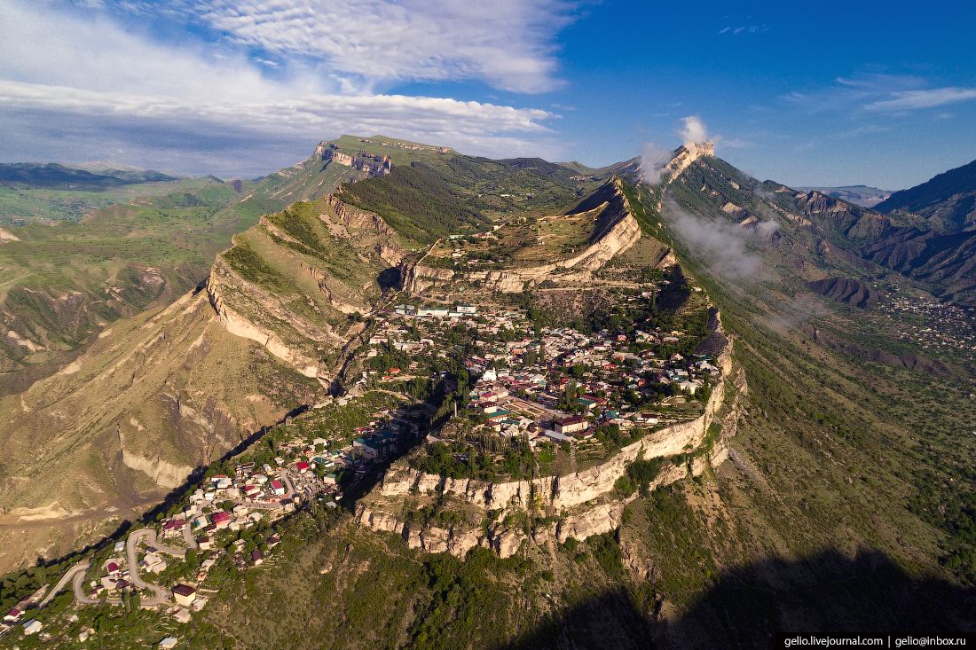
Khunzakh is a very picturesque village with a population of 4 thousand people located in the southern mountainous part of the Republic of Dagestan, 140 km southwest of the city of Makhachkala, at an altitude of about 1,700 meters above sea level.
The houses here are built on the very edge of the Khunzakh plateau, where the height of sheer cliffs reaches 100 meters. Khunzakh on Google Maps. Photos by: Slava Stepanov.
very picturesque mountain village
Tags: Dagestan Republic · Makhachkala city
20
Ekranoplan “Lun” – a unique military vehicle near Derbent
No comments · Posted by Sergei Rzhevsky in Technology, Travel
On December 30, 2021, a Project #903 Lun missile ekranoplan was towed ashore near the city of Derbent, in the Republic of Dagestan. This is the first exhibit of the future Patriot Park, which is planned to open here in 2023. Built in 1986, it became the only fully completed vehicle of this project out of eight planned due to financial problems and dubious military expediency.
An ekranoplan is a cross between a ship and an airplane. The principle of movement is similar to an air cushion, only it is created not by forcing air, but by an oncoming flow. When the flaps are lowered, the engines force air onto the wing and the ekranoplan rises out of the water. Ekranoplan “Lun” on Google Maps. Photos by: Slava Stepanov.

Tags: Dagestan Republic · Derbent city
5
Derbent – the southernmost city in Russia
No comments · Posted by Sergei Rzhevsky in Cities, Travel
Derbent is a city with a population of about 126 thousand people located in the very south of European Russia in the Republic of Dagestan on the shores of the Caspian Sea, 127 kilometers southeast of Makhachkala.
The city stands in a narrow passage between the Caspian Sea and the Caucasus Mountains. This geographical position made Derbent one of the most important points of defense for many countries, since only this 3 km wide strip of land can be used to easily bypass the Caucasus Mountains. Photos by: Slava Stepanov.
Tags: Dagestan Republic · Derbent city
27
Gamsutl – a ghost village in the mountains of Dagestan
1 Comment · Posted by Sergei Rzhevsky in History, Regions, Travel
Gamsutl is an abandoned village located at an altitude of about 1.5 thousand meters above sea level in the southern mountainous part of the Republic of Dagestan in the North Caucasus.
Translated from the Avar language, the word “gamsutl” means “at the foot of the khan’s fortress.” It is likely that the khan, the founder of Gamsutl, lived on the top of the mountain, and his troops were stationed on its slopes. The approximate age of the village is 2 thousand years.
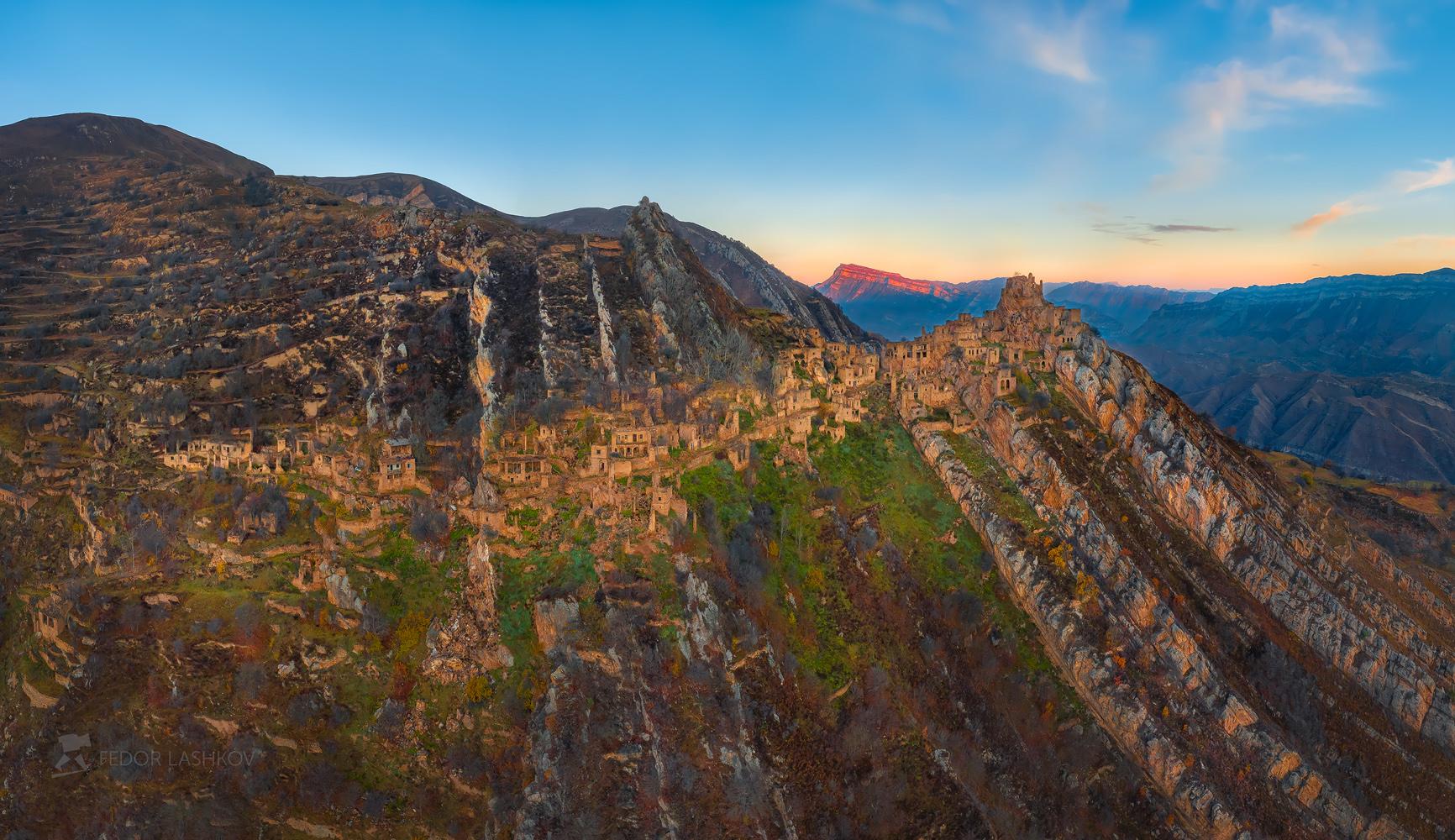
very picturesque abandoned village
Tags: Abandoned · Dagestan Republic
18
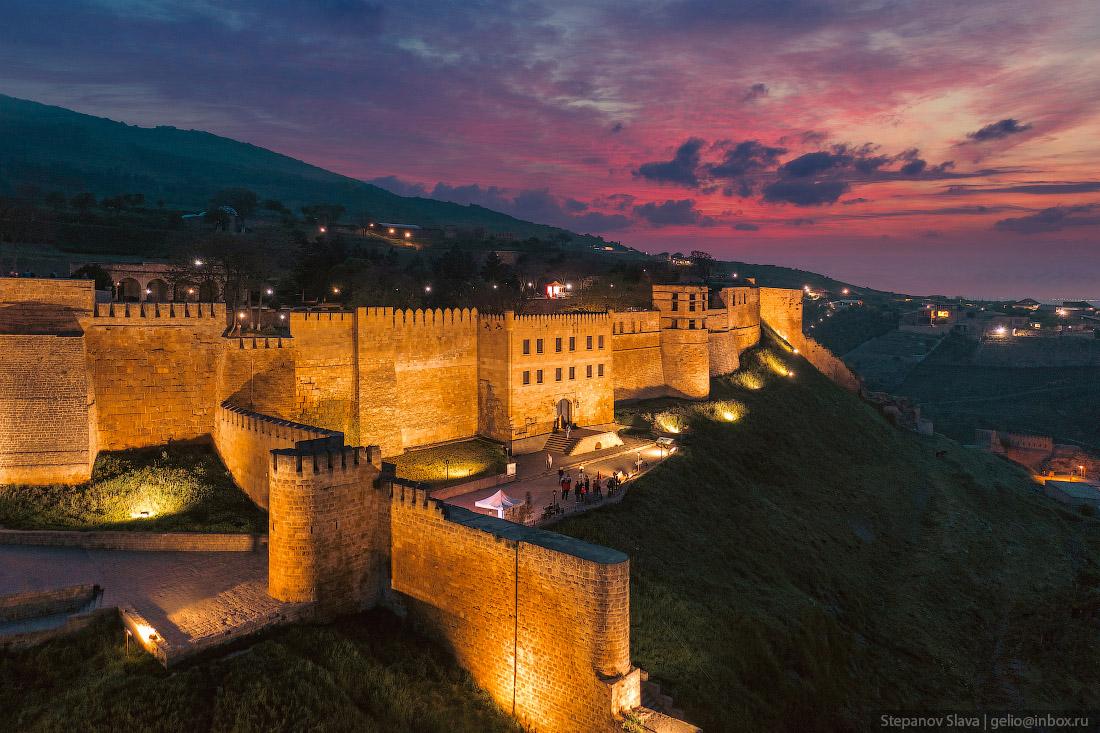
The ancient citadel of Naryn-Kala in Derbent
No comments · Posted by Sergei Rzhevsky in History, Travel
Derbent is a city located on the shores of the Caspian Sea in the Republic of Dagestan in southern Russia. It is located in the most strategically vulnerable place of the Caspian Gates, where the Greater Caucasus Mountains come closest to the sea, leaving only a narrow 3-km strip of plain.
The Derbent fortress was part of a large defensive system constructed to protect the peoples of Transcaucasia and Western Asia from the invasions of nomads from the north. The system included the walls, the citadel of Naryn-Kala, sea walls, and the Dag Bara Mountain Wall. Naryn-Kala Citadel on Google Maps. Photos by: Alexandr Lipilin.
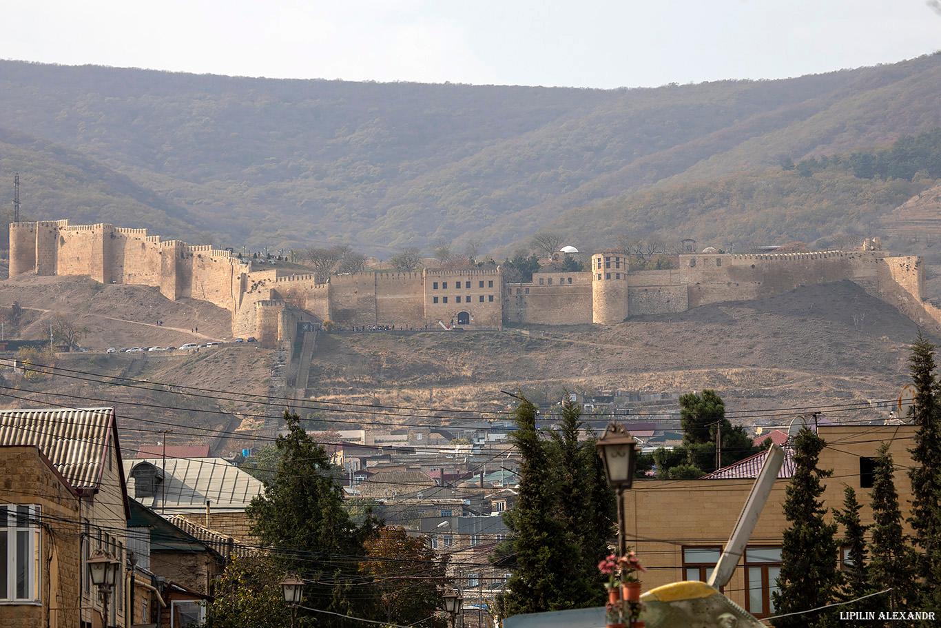
one of the oldest fortresses in Russia
Tags: Dagestan Republic · Derbent city
14
Gunib – a Village Close to the Sky
No comments · Posted by Sergei Rzhevsky in Regions, Travel
Gunib, a village of about 2,600 people located 150 km southwest of Makhachkala, is one of the most picturesque places in the Republic of Dagestan. It stands on the plateau of the same name at an altitude of 1,500 meters above sea level.
The village arose in connection with the construction of the Russian military fortification in 1862. The fortification was named after the former village of Gunib, which was located on the top of the plateau and was destroyed in 1859. Gunib on Google Maps. Photos by: Slava Stepanov.
Tags: Dagestan Republic · Makhachkala city
6
Sulak Canyon – the Deepest Canyon in Europe
No comments · Posted by Sergei Rzhevsky in Nature, Regions, Travel
Sulak Canyon, one of the most picturesque natural sights of the Republic of Dagestan, is the deepest canyon in Europe and one of the deepest in the world. The length of the canyon is 53 kilometers, the depth reaches 1,920 meters, which is about 60 meters deeper than the famous Grand Canyon in the US.
This is one of the most visited tourist sites in Dagestan. However, it is also one of the most dangerous places: high cliffs, sharp rocks, strong winds, the absence of any railings along the canyon. Sulak Canyon on Google Maps. Photos by: Murad Magomedov.
Tags: Dagestan Republic · Makhachkala city