
CAT | Regions
29
The Historic Island Town of Sviyazhsk
No comments · Posted by Sergei Rzhevsky in Cities, Regions, Travel
Sviyazhsk is a historic town with a population of about 240 people located on an island at the confluence of the Sviyaga and the Volga rivers in the Republic of Tatarstan, about 58 km south-west of Kazan.
Founded as a fortress in 1551, it became the base of Russian troops during the siege of Kazan, the capital of the Kazan Khanate, in 1552. Sviyazhsk became the first Orthodox town in the Middle Volga region, the center of the Christianization of the peoples of the Volga region. Sviyazhsk on Google Maps. Photos by: Alexander Butenko.
Sviyazhsk River Station.
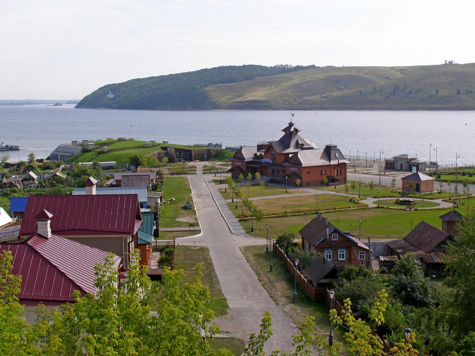

Tags: Kazan city · Tatarstan Republic
12
Wooden Church of the Nativity of Mary in Rozhdestvenskaya
No comments · Posted by Sergei Rzhevsky in Architecture, Regions, Travel
Rozhdestvenskaya is a stanitsa (a Cossack village) with a population of about 2,800 people located in Stavropol Krai in Southern Russia, about 35 km northwest of Stavropol. This settlement, founded in 1797, was named after the feast of the Nativity of the Blessed Virgin Mary.
The main architectural attraction of Rozhdestvenskaya is the Church of the Nativity of the Blessed Virgin Mary (1873) – one of the few preserved monuments of wooden architecture in the region, a cultural heritage site of regional importance. Rozhdestvenskaya on Google Maps. Photos by: Fedor Lashkov.
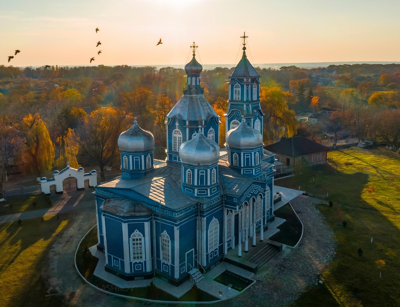
Tags: churches · Stavropol krai
19
Landscapes Illuminated by the Northern Lights in Teriberka
No comments · Posted by Sergei Rzhevsky in Nature, Regions, Travel
Teriberka is a village with a population of about 900 people located in Murmansk Oblast, in the north of the Kola Peninsula on the shore of the Barents Sea.
In the European part of Russia, Teriberka is the only place that can be reached by road to see the open Barents Sea and the Arctic Ocean. Also here you can see such a picturesque natural phenomenon as the northern lights. Teriberka on Google Maps. Photos by: Sergey Korolev.
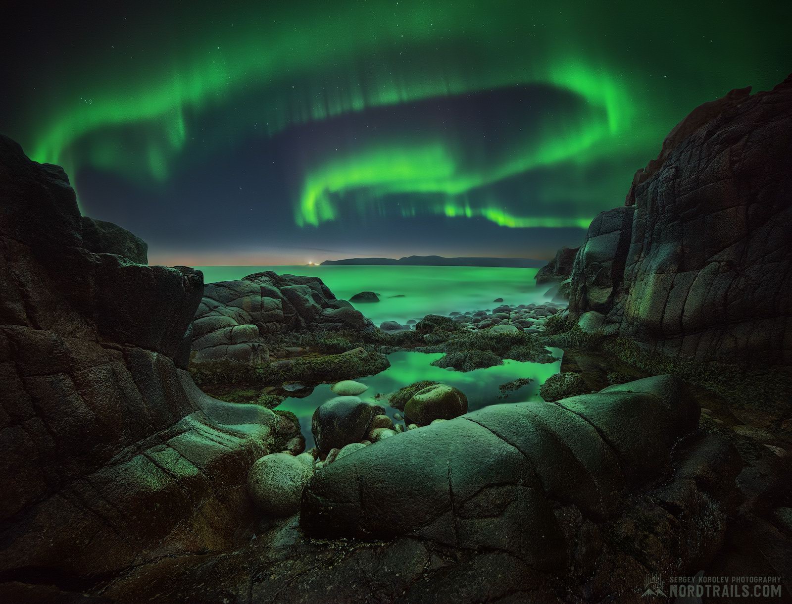
Tags: Murmansk oblast
6
Northern Zelenchuk Church in Nizhniy Arkhyz
No comments · Posted by Sergei Rzhevsky in Architecture, Regions, Travel
Zelenchuk churches (Northern, Middle, and Southern) are the three oldest Orthodox churches of the Caucasus located in the valley of the Bolshoy Zelenchuk River near the village of Nizhniy Arkhyz in the central part of the Republic of Karachay-Cherkessia.
Northern Zelenchuk Church, the largest of them, was constructed in the late 10th – early 11th centuries. This beautiful building, harmoniously integrated into the surrounding landscape, is built of sandstone. The basis of the construction is a cross with a dome in the center. Northern Zelenchuk Church on Google Maps. Photos by: Fedor Lashkov.
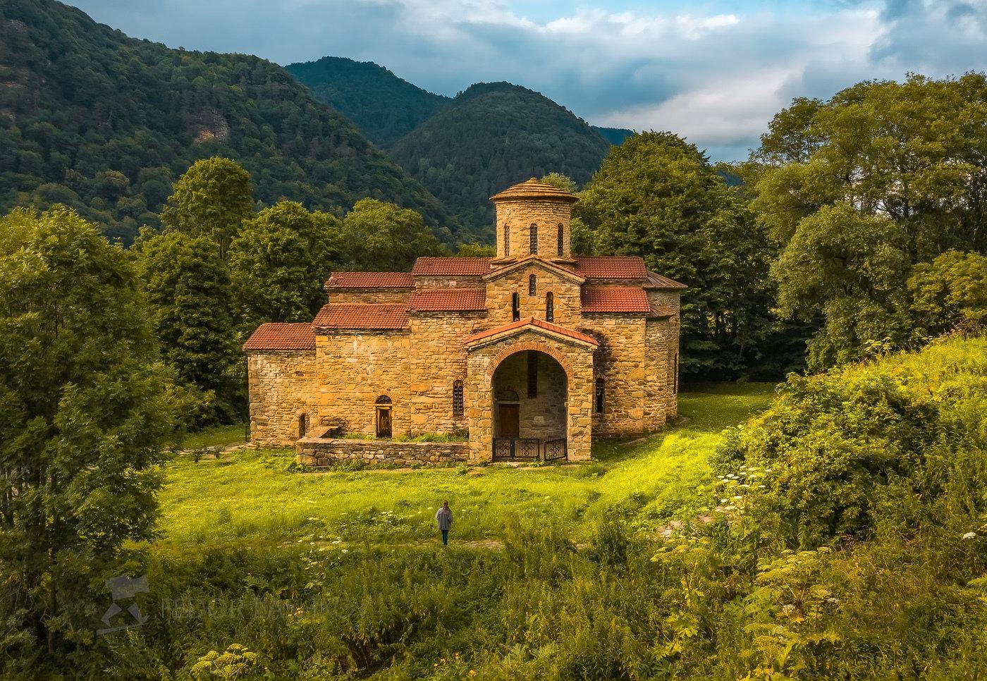
Tags: churches · Karachay-Cherkessia Republic
29
Anadyr – the Easternmost City of Russia
2 Comments · Posted by Sergei Rzhevsky in Cities, Photos, Regions
Anadyr, the administrative center of the Chukotka Autonomous Okrug, is a port city with a population of about 15 thousand people located in the extreme north-east of Russia in the permafrost zone.
Today, a fish processing plant and energy enterprises are operating in the city. Gold and coal are being mined in its vicinity. Reindeer husbandry, fishing, and hunting are also developed. Photos by: Slava Stepanov.

Tags: Anadyr city · Chukotka okrug
22
Astashovo Palace – One of the Best Wooden Houses in Russia
No comments · Posted by Sergei Rzhevsky in Architecture, Regions, Travel
The wooden house in Astashovo has an amazing story that dates back to 1897. There was everything here: prosperity, decline, abandonment, and incredible rebirth. It is located in the abandoned village of Astashovo (also known as Ostashevo) in the Chukhloma District of Kostroma Oblast.
It is the main house of the Astashovo Estate once owned by a peasant Martyan Sazonov. After the abolition of serfdom, Martyan moved to work in St. Petersburg, where he specialized as a cabinetmaker. By 1897, he became rich and decided to return to his home village, then the construction of the house began. Astashovo Wooden Palace on Google Maps. Photos by: Roman Smirnov.
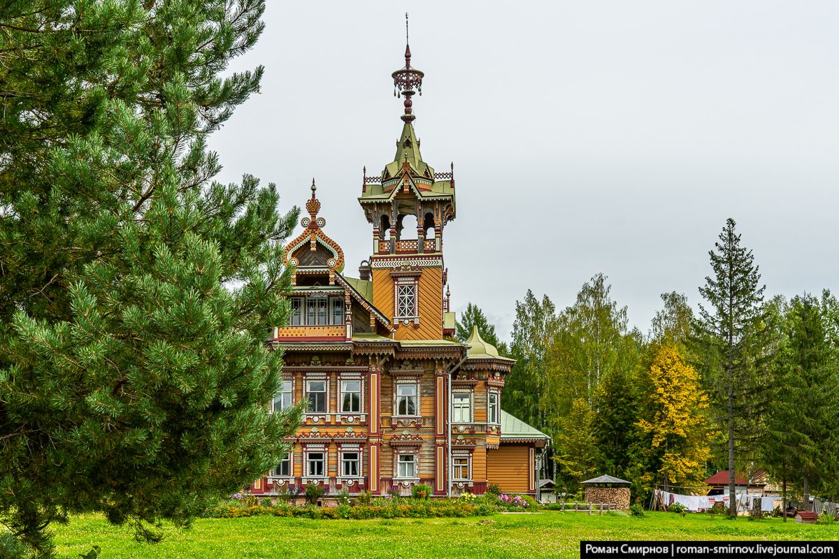
Tags: Kostroma oblast · museum
14
Gunib – a Village Close to the Sky
No comments · Posted by Sergei Rzhevsky in Regions, Travel
Gunib, a village of about 2,600 people located 150 km southwest of Makhachkala, is one of the most picturesque places in the Republic of Dagestan. It stands on the plateau of the same name at an altitude of 1,500 meters above sea level.
The village arose in connection with the construction of the Russian military fortification in 1862. The fortification was named after the former village of Gunib, which was located on the top of the plateau and was destroyed in 1859. Gunib on Google Maps. Photos by: Slava Stepanov.
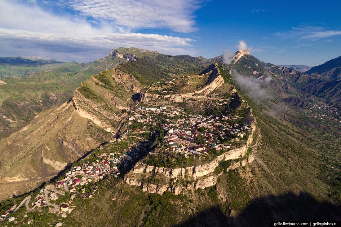
Tags: Dagestan Republic · Makhachkala city
21
Lena Pillars – the view from above
2 Comments · Posted by Sergei Rzhevsky in Nature, Regions, Travel
“Lena Pillars” is a geological formation and a national park located on the banks of the Lena River in the Republic of Sakha (Yakutia), about 170 km south-west of Yakutsk. Lena Pillars are a complex of vertically elongated rocks up to 220 meters high stretching for many kilometers along the Lena River bank.
In 2012, this natural monument received the status of a UNESCO World Heritage Site. In the language of the locals, the pillars are called “Turuuk Hayalara” (“Mountains of Rising Gods”). The main objective of the park is the development of ecological tourism. Lena Pillars on Google Maps. Photos by: Slava Stepanov.
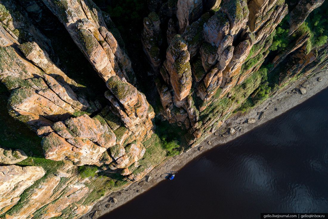
fly over magnificent stone pillars
Tags: Sakha Republic · Yakutsk city
6
Sulak Canyon – the Deepest Canyon in Europe
No comments · Posted by Sergei Rzhevsky in Nature, Regions, Travel
Sulak Canyon, one of the most picturesque natural sights of the Republic of Dagestan, is the deepest canyon in Europe and one of the deepest in the world. The length of the canyon is 53 kilometers, the depth reaches 1,920 meters, which is about 60 meters deeper than the famous Grand Canyon in the US.
This is one of the most visited tourist sites in Dagestan. However, it is also one of the most dangerous places: high cliffs, sharp rocks, strong winds, the absence of any railings along the canyon. Sulak Canyon on Google Maps. Photos by: Murad Magomedov.
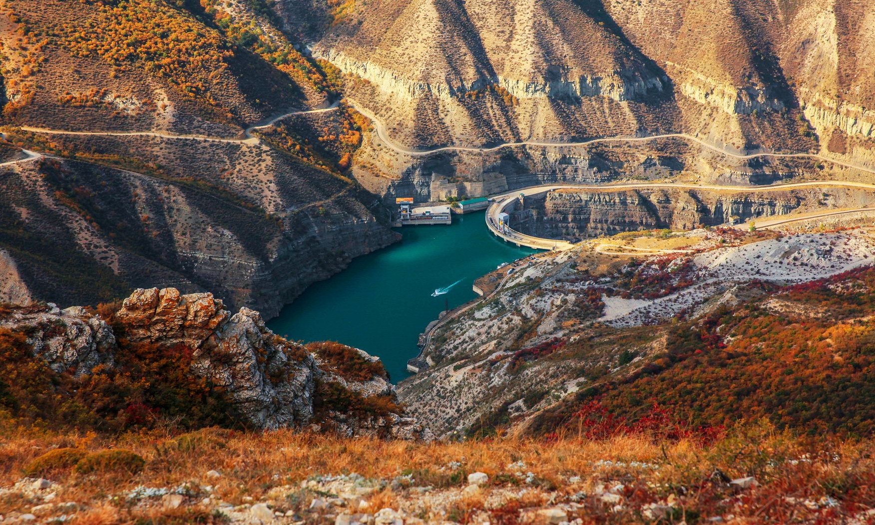
Tags: Dagestan Republic · Makhachkala city
16
Abandoned Uranium Mine in the Stavropol Region
1 Comment · Posted by Sergei Rzhevsky in Entertainment, Photos, Regions
Lermontovsky Uranium Mine #1 is a former uranium mining enterprise located on Mount Beshtau near the city of Pyatigorsk, about 200 km south-east of Stavropol. The mine was closed in 1975.
Today, it is a popular object with diggers and other extreme lovers. The official name “Mine #1” was used in the documents due to the high secrecy of this object. Mount Beshtau on Google Maps. Photos by: Vladimir Mulder.

Tags: Abandoned · Pyatigorsk city · Stavropol krai