
CAT | Regions
26
Holy Assumption Monastery in Staritsa
No comments · Posted by Sergei Rzhevsky in Regions, Religion, Travel
Staritsky Holy Assumption Monastery is an Orthodox monastery located in the town of Staritsa, on the right bank of the Volga River, in the Tver region.
The ensemble of the monastery is one of the most important and interesting architectural complexes in the region. This is one of the oldest monasteries in Russia, officially founded in the first half of the 16th century, although the first monks came here from Kiev-Pechersk Lavra in 1110.
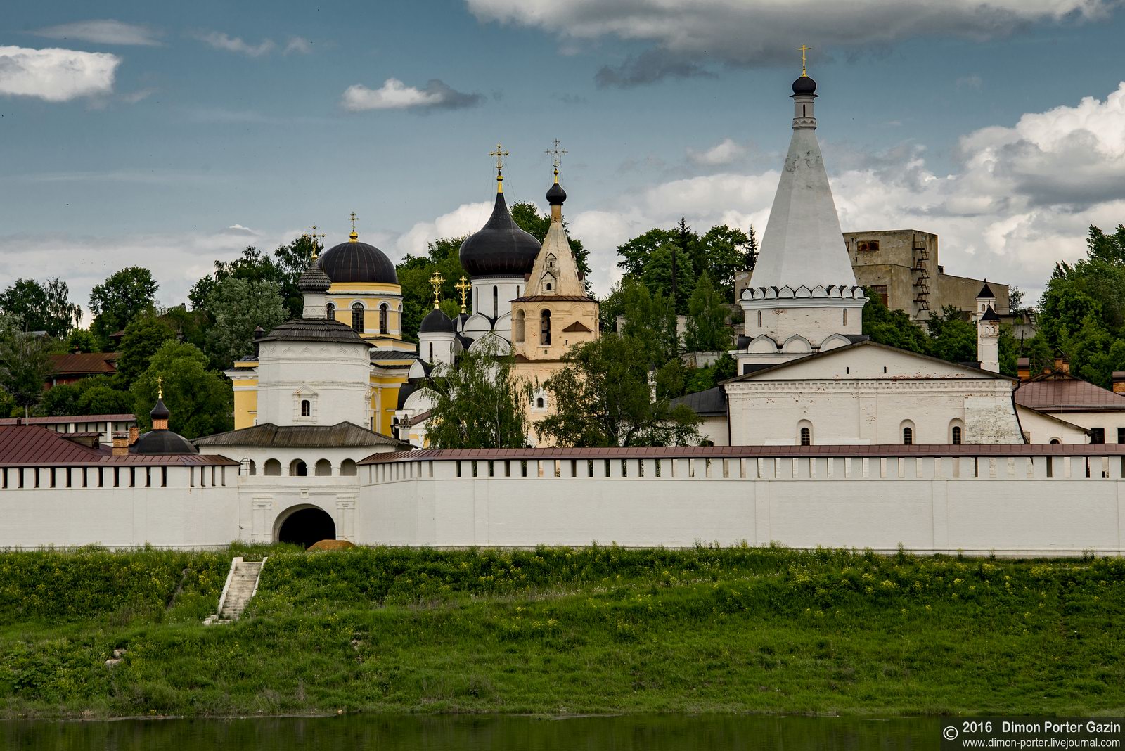

Tags: churches · Tver oblast
29
Early in the morning in the historic village of Vvedenye
No comments · Posted by Sergei Rzhevsky in Photos, Regions, Travel
Vvedenye is a small village with a population of about 500 people located in the Shuyskiy district of the Ivanovo region, about 10 km north-west of the town of Shuya and 32 km from Ivanovo, the regional capital.
This is one of the most interesting villages of the Ivanovo region with a rich history and a number of temple complexes. The history of the village is directly connected with Nikolo-Shartomskiy monastery founded in the 14th century.

one foggy morning in Russian province
Tags: churches · Ivanovo oblast
21
The Flooded Bell Tower of Kalyazin
No comments · Posted by Sergei Rzhevsky in Photos, Regions, Travel
Kalyazin is a small town with a population of about 13 thousand people located in the Tver region, on the right bank of the Volga River (Uglich Reservoir), 200 km from Moscow and 160 km from Tver.
In 1939-1940, part of the territory of the old town, including all the main historical and architectural monuments, was flooded during the construction of the Uglich hydroelectric power station.

the bell tower in the middle of the Volga
Tags: Tver oblast
28
Stunning nature of the Caucasus – climbing Stolovaya Mountain
No comments · Posted by Sergei Rzhevsky in Nature, Regions, Travel
Stolovaya is a flat mountain (3,003 meters) located on the border of the Republic of Ingushetia and the Republic of North Ossetia in the North Caucasus. In Russian the word “stol” means “table”.
This mountain, depicted on the state emblem of Ingushetia, is visible from Magas, the capital of Ingushetia, and Vladikavkaz, the capital of North Ossetia (also depicted on the emblem of Vladikavkaz). Stolovaya Mountain on Google Maps. Photos by: Timur Agirov.
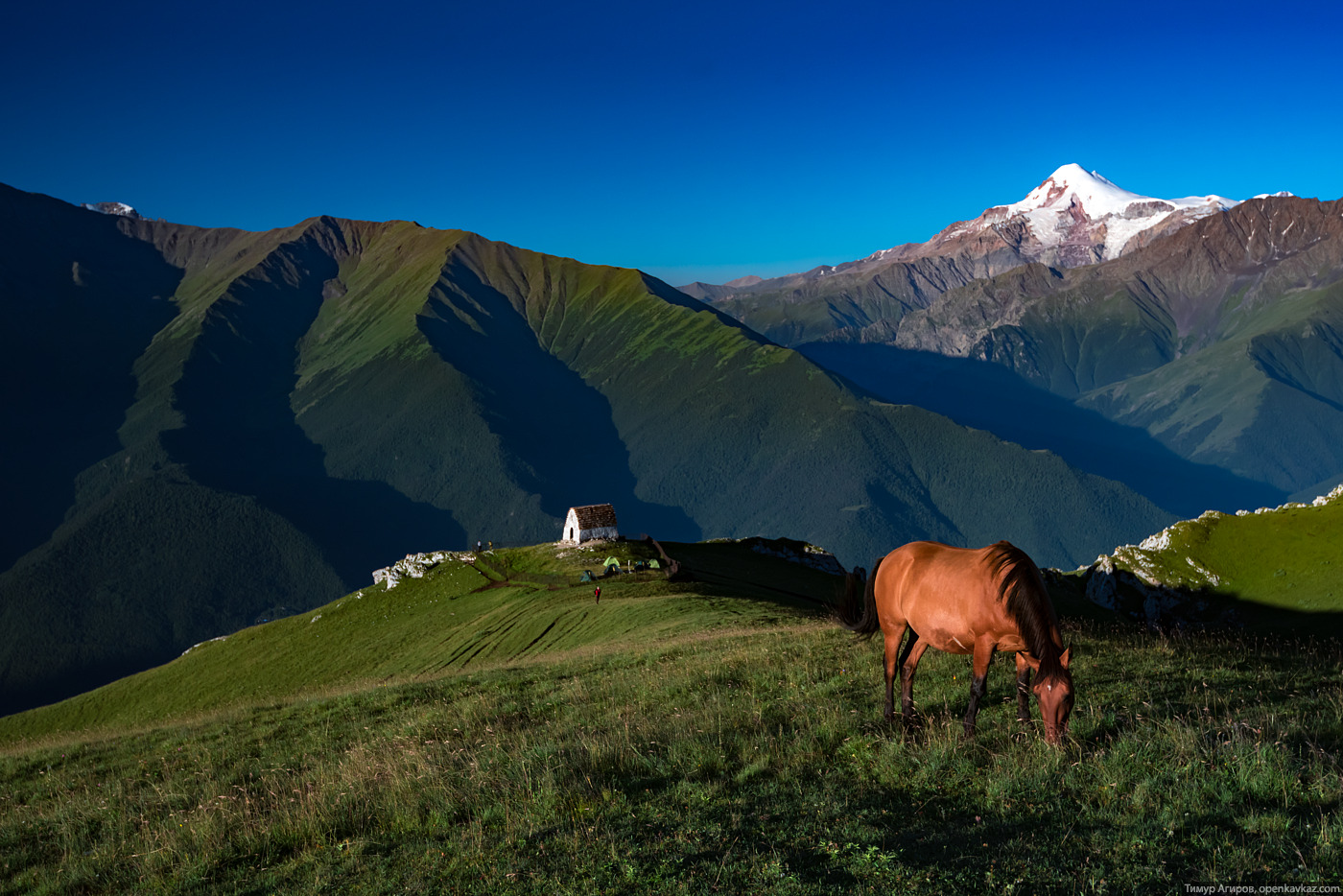
climb to the top of Stolovaya Mountain
Tags: Ingushetia Republic · North Ossetia Republic
24
The largest coal strip mine in Russia
No comments · Posted by Sergei Rzhevsky in Business, Economics, Regions
Borodinsky coal strip mine is located 7 km from the town of Borodino in the Krasnoyarsk region.
In January 2016, the one billionth ton of coal was mined here, making it the largest coal strip mine in the country. It provides jobs for about 1,500 people.
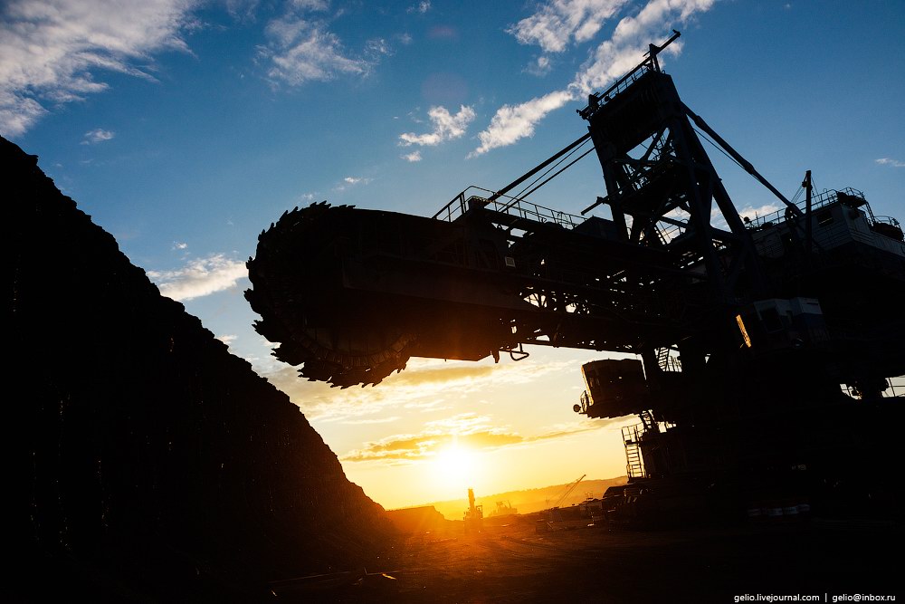
take a look at the mine and equipment
Tags: Krasnoyarsk krai
20
Stunning Martian Landscapes in Altai Republic
No comments · Posted by Sergei Rzhevsky in Nature, Photos, Regions
Multi-colored mountains of Kyzyl-Chin, located near the village of Chagan-Uzun in the Altai Republic, is a great place for photographers, lovers of geology and natural beauty. Clays of different colors create unique natural scenery.
The local mountains look as if they are painted in stripes of different shades of red, yellow and green. This place situated at the beginning of the Chui steppe, about 7.5 km from Chui tract, looks like a real Mars. Kyzyl-Chin on Google Maps. Photos by: Anton Petrus.
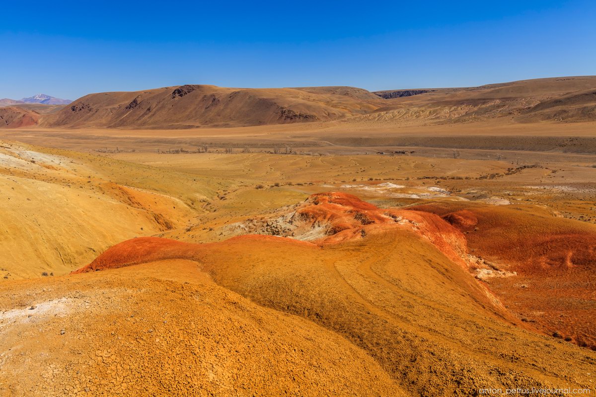
Tags: Altay Republic
17
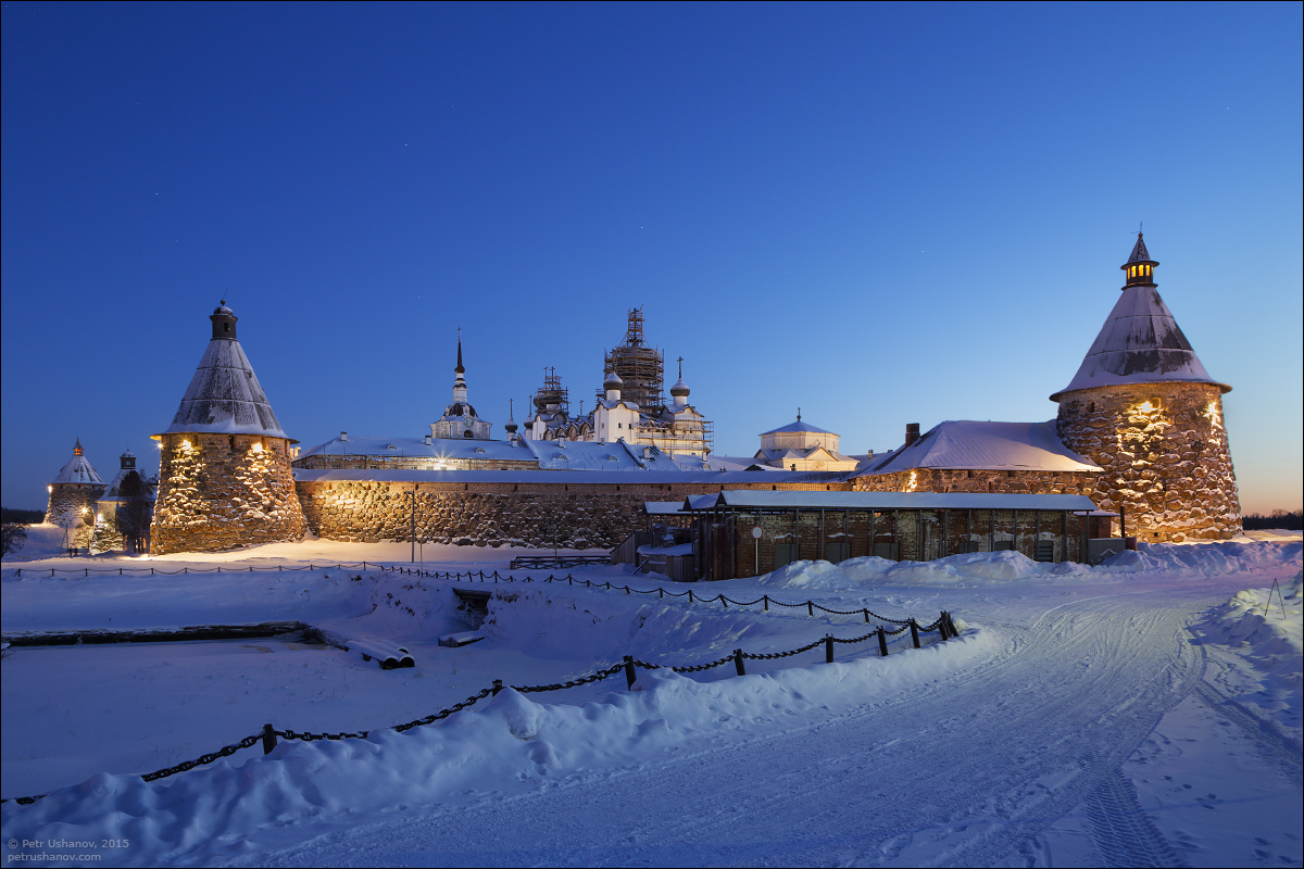
Solovki – the beauty of the Russian North
No comments · Posted by Sergei Rzhevsky in Regions, Religion, Travel
Solovetsky Islands or simply Solovki is an archipelago located in the White Sea (Arkhangelsk oblast), consisting of six major islands and more than 100 small islands.
The archipelago and the five-kilometer water area of the White Sea are included in the protected area “Solovetsky State Historical and Architectural Museum-Reserve.” Photos by: Petr Ushanov.
Tags: Arkhangelsk oblast
9
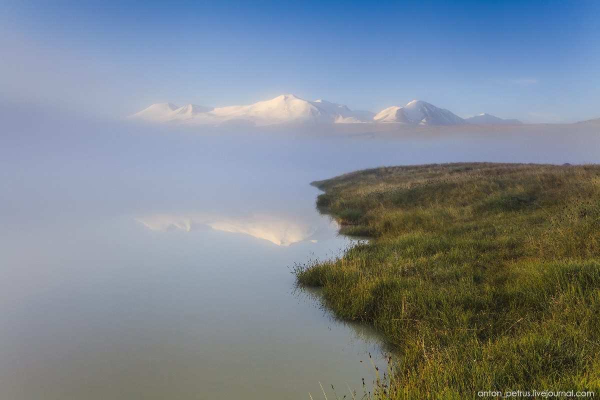
Amazing scenery of Ukok Plateau
No comments · Posted by Sergei Rzhevsky in Nature, Regions, Travel
Ukok is a plateau located in the south of the Altai Republic, on the border of Kazakhstan,China, Mongolia, and Russia.
It is a unique and beautiful place that keeps a lot of secrets and unsolved mysteries, with hundreds of lakes and rivers and snowy mountains. Ukok Plateau on Google Maps. Photos by: Anton Petrus.
Tags: Altay Republic
24
Manpupuner rock formations – a natural wonder of Russia
2 Comments · Posted by Sergei Rzhevsky in Nature, Regions, Travel
Manpupuner rock formations or Pillars of weathering are a geological monument located in the Komi Republic, on the territory of the Pechora-Ilych nature reserve, on the mountain Man-Pupu-ner (“a small mountain of idols” on the Mansi language).
The height of the pillars varies from 30 to 42 meters. There are numerous legends associated with this unique place, it was the object of the Mansi cult.
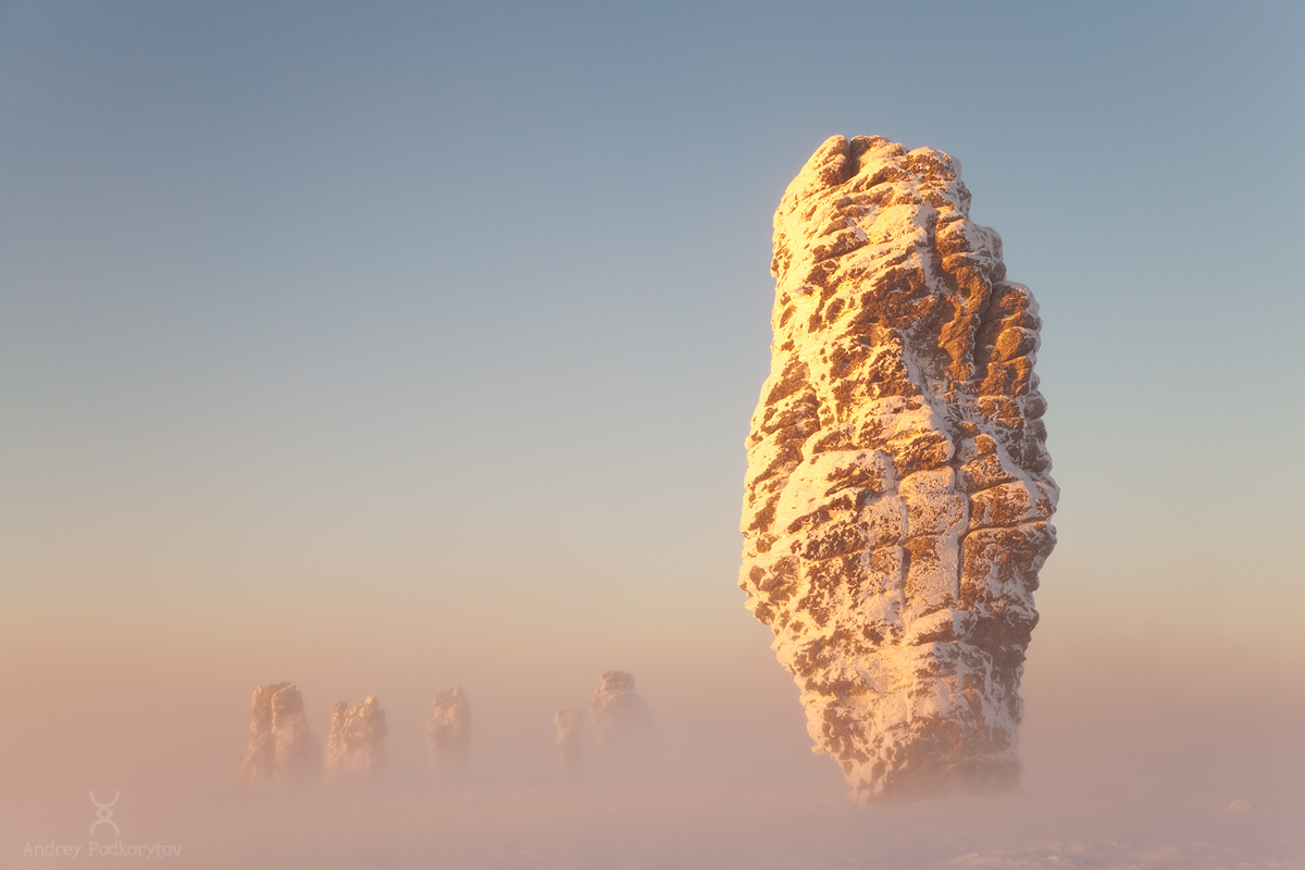
Tags: Komi Republic · landscapes
20
Belyaev Manor in the village of Voskresenskoye
No comments · Posted by Sergei Rzhevsky in Architecture, Photos, Regions
Voskresenskoye is a small village with a population of about 6,000 people located 130 km north-east of Nizhny Novgorod, on the banks of the Vetluga River. Voskresenskoye is known since the 16th century as a trading village. Local residents were busy in agriculture and timber industry.
Let’s take a look at the estate built by Sergey Nikanorovich Belyaev, one of the main local timber merchants, in 1904-1905. This amazing building decorated with old Russian carving is a shining example of the merchant’s house built using motifs of Russian folk architecture. Voskresenskoye on Google Maps. Photos by: Denis Spirin.
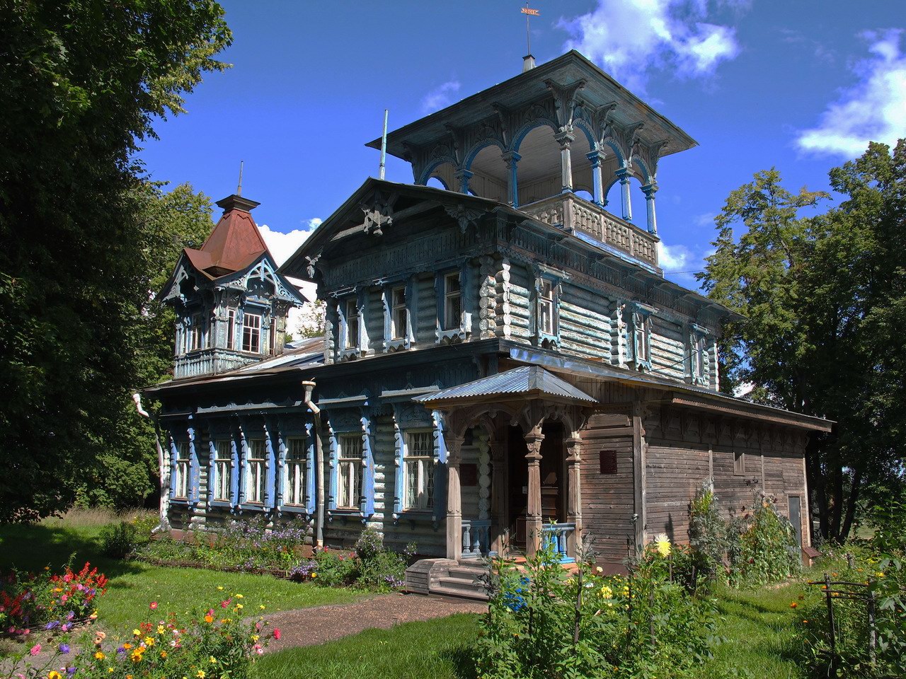
Tags: Nizhegorodskaya oblast