
CAT | Travel
13
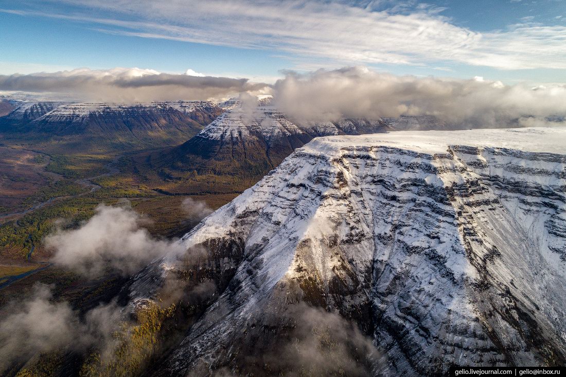
Putorana Plateau – the Mountains with Flat Tops
No comments · Posted by Sergei Rzhevsky in Nature, Regions, Travel
Putorana is a strongly dissected mountain range located in the northwest of Krasnoyarsk Krai. The nearest large settlement is the city of Norilsk. The surface of the plateau is covered with basaltic lava flows often referred to as the Siberian Traps. This is one of the most poorly studied and inaccessible regions of Russia.
The maximum height of the plateau is 1,701 meters. The name “Putorana”, translated from Evenki, means “lakes with steep banks”. The plateau area is about 250,000 square kilometers. The Putoransky Nature Reserve, recognized by UNESCO as a World Heritage Site, is located on the plateau. The Putorana Plateau on Google Maps. Photos by: Slava Stepanov.

Tags: Krasnoyarsk krai · Norilsk city
6
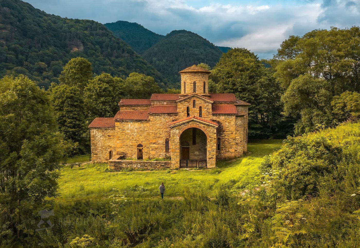
Northern Zelenchuk Church in Nizhniy Arkhyz
No comments · Posted by Sergei Rzhevsky in Architecture, Regions, Travel
Zelenchuk churches (Northern, Middle, and Southern) are the three oldest Orthodox churches of the Caucasus located in the valley of the Bolshoy Zelenchuk River near the village of Nizhniy Arkhyz in the central part of the Republic of Karachay-Cherkessia.
Northern Zelenchuk Church, the largest of them, was constructed in the late 10th – early 11th centuries. This beautiful building, harmoniously integrated into the surrounding landscape, is built of sandstone. The basis of the construction is a cross with a dome in the center. Northern Zelenchuk Church on Google Maps. Photos by: Fedor Lashkov.
Tags: churches · Karachay-Cherkessia Republic
22
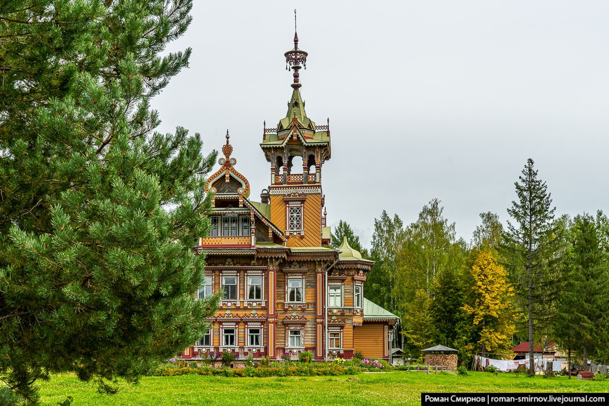
Astashovo Palace – One of the Best Wooden Houses in Russia
No comments · Posted by Sergei Rzhevsky in Architecture, Regions, Travel
The wooden house in Astashovo has an amazing story that dates back to 1897. There was everything here: prosperity, decline, abandonment, and incredible rebirth. It is located in the abandoned village of Astashovo (also known as Ostashevo) in the Chukhloma District of Kostroma Oblast.
It is the main house of the Astashovo Estate once owned by a peasant Martyan Sazonov. After the abolition of serfdom, Martyan moved to work in St. Petersburg, where he specialized as a cabinetmaker. By 1897, he became rich and decided to return to his home village, then the construction of the house began. Astashovo Wooden Palace on Google Maps. Photos by: Roman Smirnov.
Tags: Kostroma oblast · museum
14
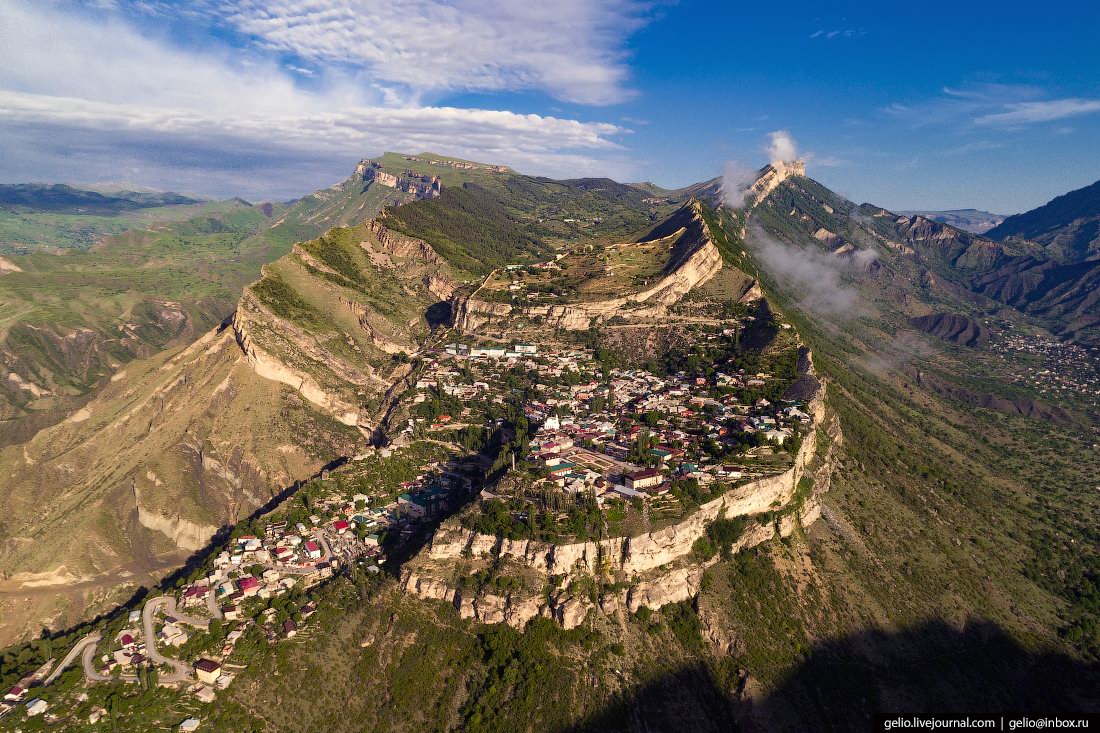
Gunib – a Village Close to the Sky
No comments · Posted by Sergei Rzhevsky in Regions, Travel
Gunib, a village of about 2,600 people located 150 km southwest of Makhachkala, is one of the most picturesque places in the Republic of Dagestan. It stands on the plateau of the same name at an altitude of 1,500 meters above sea level.
The village arose in connection with the construction of the Russian military fortification in 1862. The fortification was named after the former village of Gunib, which was located on the top of the plateau and was destroyed in 1859. Gunib on Google Maps. Photos by: Slava Stepanov.
Tags: Dagestan Republic · Makhachkala city
12
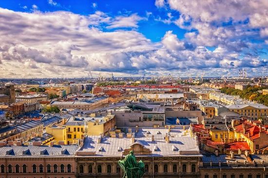
What to Do in St. Petersburg: the Best Sights and Activities
No comments · Posted by Alex Smirnov in Cities, Entertainment, Travel
The cultural capital of Russia has so much to offer that more than 8 million people visited the city in 2017, and the numbers are growing. Some choose St. Petersburg as the first stop of their Russian holiday and only have time to visit the most iconic buildings and monuments of St. Petersburg, others decide to dedicate some time to explore the less-touristy spots in the city.
To encourage and facilitate international tourism, the Russian government has even launched a new electronic visa system that will allow foreign travelers to apply for an eVisa for St. Petersburg entirely online before leaving for Russia. There has really never been a better time to visit St. Petersburg.
short guide to the second capital of Russia
Tags: Saint Petersburg city
6
The Beauty of Sofia Falls in Karachay-Cherkessia
No comments · Posted by Sergei Rzhevsky in Nature, Regions, Travel
Sofia Falls are waterfalls of glacial origin flowing from the Sofia Glacier of Mount Sofia (3,637 meters) – one of the main natural attractions of the Arkhyz ski resort located in the southern part of the Republic of Karachay-Cherkessia in the Western Caucasus.
These picturesque waterfalls are located about 15 km south of the village of Arkhyz. Sofia Falls become the most full-flowing at the height of summer (July, August), when the glacier is actively melting. The following photos were taken in late July by Fedor Lashkov. Sofia Falls on Google Maps.

Tags: Cherkessk city · Karachay-Cherkessia Republic · landscapes
27
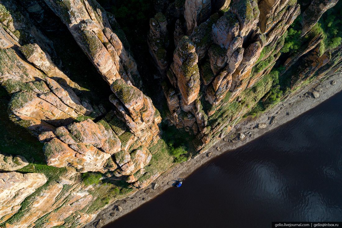
The Granite Kingdom of the Ulakhan-Sis Range
No comments · Posted by Sergei Rzhevsky in Nature, Regions, Travel
A lot of people know about the picturesque remnant cliffs on the Manpupuner Plateau in the Northern Urals in the Republic of Komi.
However, in Russia, there is a number of similar places and one of them is the mountain range of the Ulakhan-Sis – a geological complex located in the polar part of Yakutia between the Indigirka and Alazeya rivers. The Ulakhan-Sis on Google Maps. Photos by: Sergei Karpukhin.

Tags: Sakha Republic · Yakutsk city
18
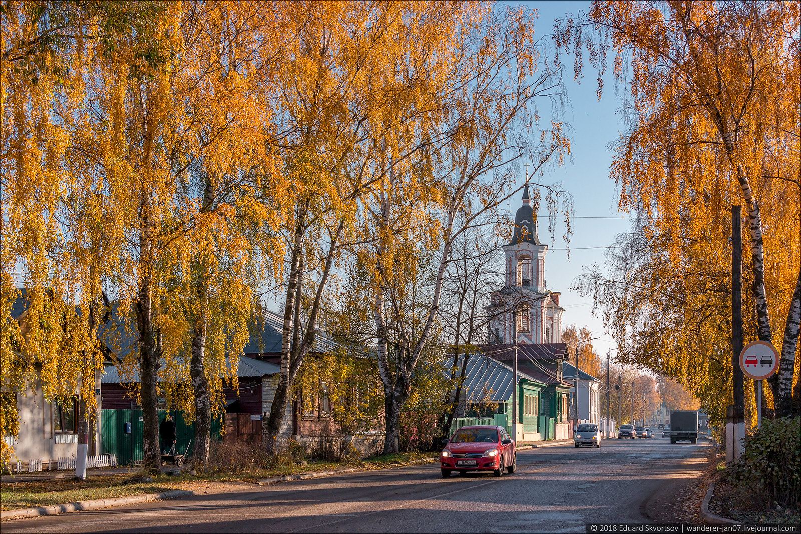
Nerekhta – a picturesque old Russian provincial town
No comments · Posted by Sergei Rzhevsky in Architecture, Cities, Travel
Nerekhta is a small provincial town with a population of about 21 thousand people located in Kostroma Oblast, about 47 km southwest of Kostroma and 71 km southeast of Yaroslavl.
First mentioned in 1214, this old town is included in the famous tourist route known as the Golden Ring of Russia. However, due to the fact that the M-8 federal highway passes away from it, tourists rarely come here (especially organized tourist groups). Nerekhta on Google Maps. Photos by: Eduard Skvortsov.
Tags: Kostroma oblast
6
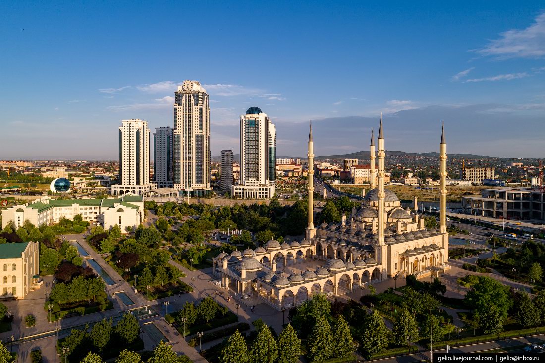
The rebuilt center of Grozny from above
No comments · Posted by Sergei Rzhevsky in Cities, Photos, Travel
Grozny, the capital of the Chechen Republic, is a city with a population of about 300 thousand people located in the North Caucasus in the south of the European part of Russia.
During the First and Second Chechen Wars, the city, especially its central part, was almost completely destroyed. In 2003, Grozny was recognized by the UN Commission as the most ruined city on Earth since the Second World War. Photos by: Slava Stepanov.
Tags: Chechnya Republic · Grozny city
21
Lena Pillars – the view from above
2 Comments · Posted by Sergei Rzhevsky in Nature, Regions, Travel
“Lena Pillars” is a geological formation and a national park located on the banks of the Lena River in the Republic of Sakha (Yakutia), about 170 km south-west of Yakutsk. Lena Pillars are a complex of vertically elongated rocks up to 220 meters high stretching for many kilometers along the Lena River bank.
In 2012, this natural monument received the status of a UNESCO World Heritage Site. In the language of the locals, the pillars are called “Turuuk Hayalara” (“Mountains of Rising Gods”). The main objective of the park is the development of ecological tourism. Lena Pillars on Google Maps. Photos by: Slava Stepanov.
fly over magnificent stone pillars
Tags: Sakha Republic · Yakutsk city