
CAT | Nature
13
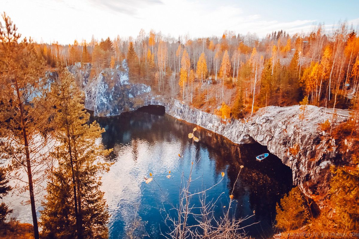
Autumn in the Ruskeala Mountain Park
No comments · Posted by Sergei Rzhevsky in Nature, Regions, Travel
The mountain park “Ruskeala” is a tourist complex located in the Sortavala district of the Republic of Karelia, near the border with Finland. The basis of the complex is an abandoned marble quarry filled with groundwater – a cultural heritage site and historic monument.
The park is located near the village of Ruskeala, about 30 kilometers north of the town of Sortavala. The length of the former marble quarry from north to south is 460 meters, the width – up to 100 meters. Ruskeala Park on Google Maps. Photos by: Maria Mitrofanova.

Tags: Abandoned · Karelia Republic · Petrozavodsk city
27
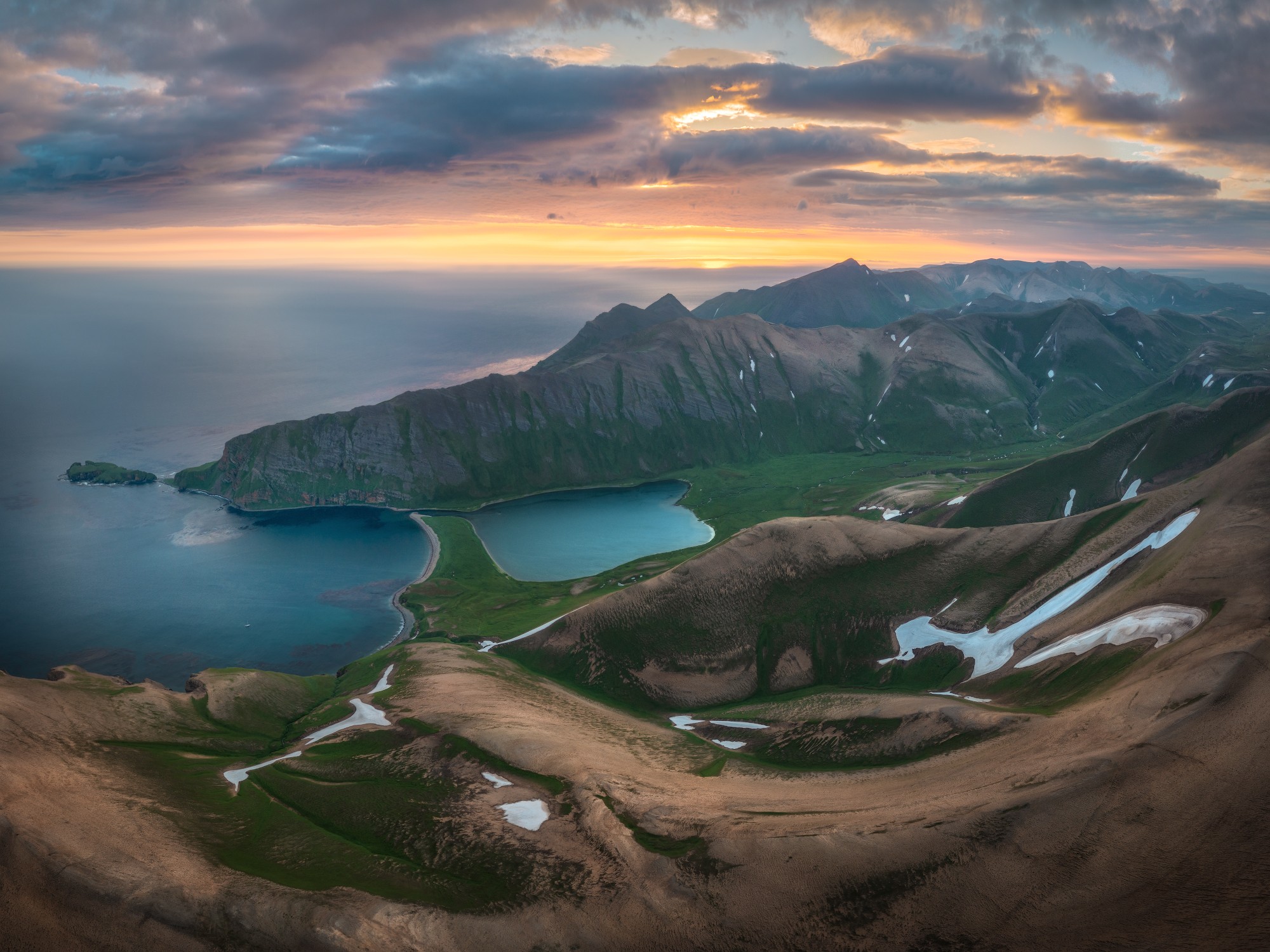
The Pristine Nature of the Commander Islands of Russia
No comments · Posted by Sergei Rzhevsky in Nature, Regions, Travel
The Commander (Komandorskiye) Islands are an archipelago of two large and two small islands located in the southwestern Bering Sea of the Pacific Ocean, part of Kamchatka Krai of Russia. The archipelago is named after the navigator Commander Vitus Bering, who discovered these islands in 1741.
Bering Island is the largest island of the Commander Islands. It is about 90 km long and 24 km wide. The grave of Vitus Bering and several of his comrades are located here. There is only one settlement here – the village of Nikolskoye with a population of about 600 people. Bering Island, like all the Commander Islands, is located on an underwater ridge that extends from Alaska. The Aleutian Islands of the US state of Alaska are also located on this ridge. Photos by Andrey Grachev.
one of the most remote places in Russia
Tags: Kamchatka krai · Petropavlovsk-Kamchatsky city
3
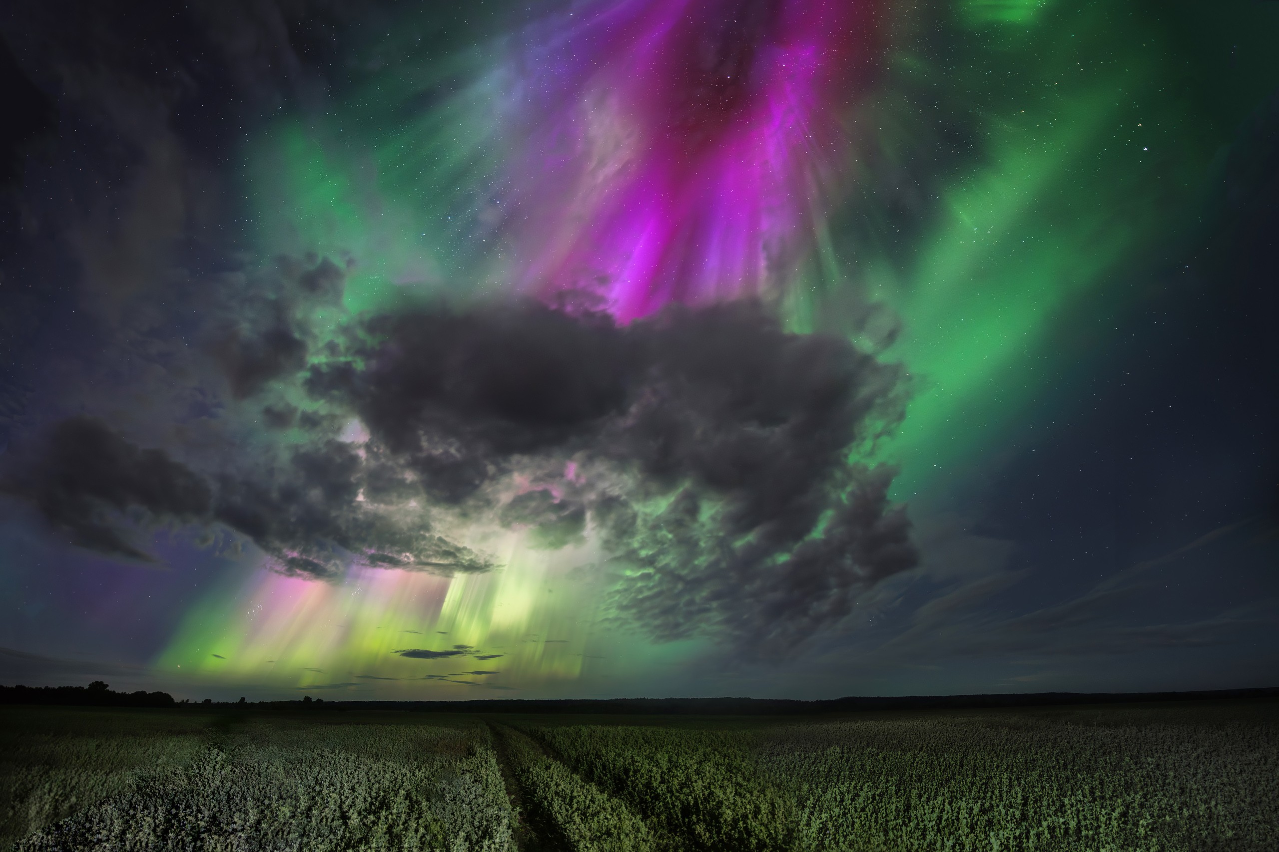
The Brightest Northern Lights in Arkhangelsk Oblast
No comments · Posted by Sergei Rzhevsky in Nature, Regions, Travel
In 2024-2025, there is a peak in solar activity, which directly affects the intensity and beauty of such a natural phenomenon as the northern lights. These photos were taken in the Kotlas district in the southeastern part of Arkhangelsk Oblast on the night of August 12-13, 2024. According to the author of the photos, this was the most active and brightest aurora he has ever seen.
Each northern light is unique. Sometimes they look like green stripes that encircle the night sky. Other times, the northern lights appear as a shimmering canopy or resemble a glowing fog. Their primary color is green, often with shades of pink around the edges and purple in the center. Photos by: Evgeny Smolsky.
amazingly strong northern lights
Tags: Arkhangelsk oblast
28
Amazing Landscapes of Kamchatka
No comments · Posted by Sergei Rzhevsky in Nature, Regions, Travel
Kamchatka is a peninsula stretching from north to south for about 1,200 km in the northeast of Eurasia. From the west it is washed by the Sea of Okhotsk, from the east – by the Bering Sea and the Pacific Ocean. Kamchatka Krai, one of the federal subjects of Russia, is located on the territory of the peninsula.
Kamchatka is a land of contrasts, which looks completely different from Central Russia. This is the land of volcanoes and glaciers, hot springs and boiling geysers, fast-flowing rivers, lakes and waterfalls. There are 414 glaciers and 160 volcanoes, 29 of which are active. Kamchatka volcanoes are included in the UNESCO World Heritage. Photos by: Sergey Makurin.

Tags: Kamchatka krai
12
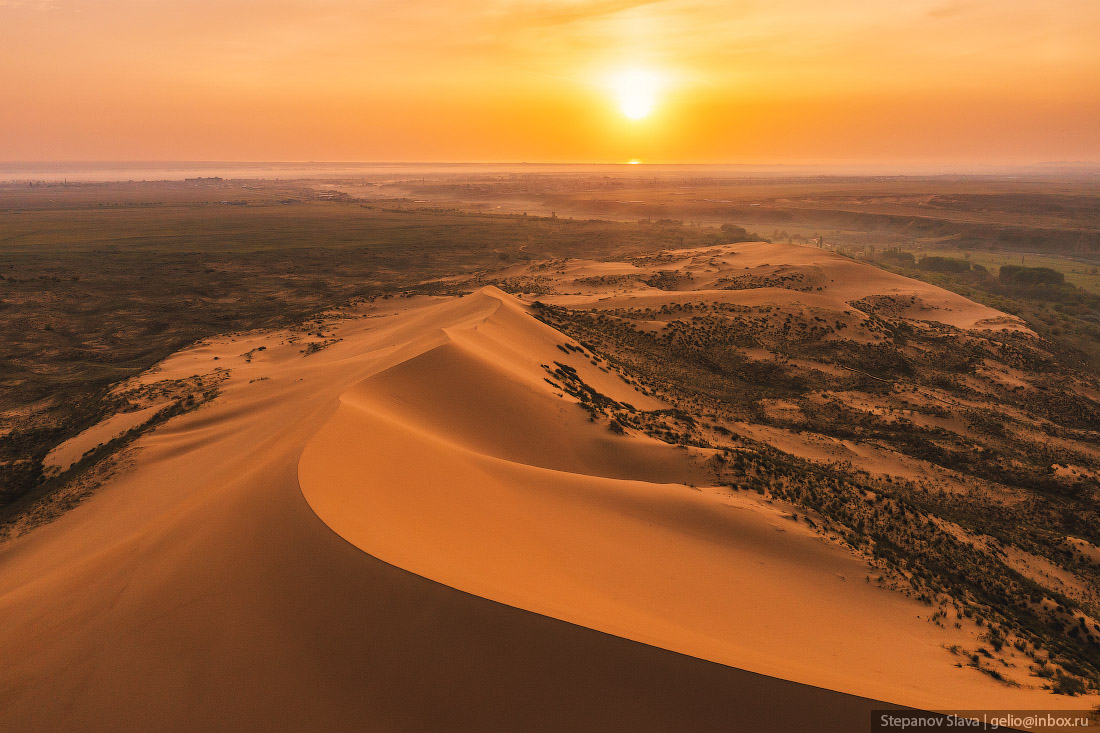
Sarykum – the Largest Sand Dune in Europe
No comments · Posted by Sergei Rzhevsky in Nature, Regions, Travel
Sarykum or Sary-Kum (translated from the Kumyk language as “Yellow Sand”) is the largest sand dune in Europe, located in the central part of the Republic of Dagestan, about 18 km northwest of Makhachkala. It is one of the largest sand dunes in Eurasia, approximately 3 km long, 2 km wide and up to 262 meters high.
The dune is located in a protected area, part of the Dagestan Nature Reserve, created on January 9, 1987. In 1968, several scenes of the famous Soviet movie “White Sun of the Desert” were filmed here. The Sarykum Sand Dune on Google Maps. Photos by: Slava Stepanov.
Tags: Dagestan Republic · Makhachkala city
26
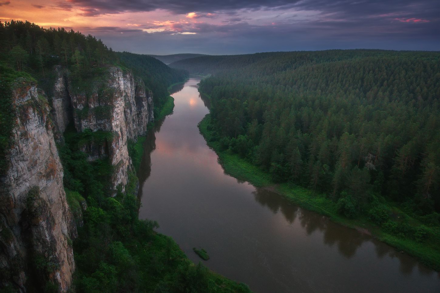
Magnificent Landscapes of Ayskiye Pritosy
No comments · Posted by Sergei Rzhevsky in Nature, Regions, Travel
The Ay River is the largest tributary of the Ufa River and one of the most picturesque places in the Southern Urals. Ayskiye Pritosy is a unique natural geological object located on the Ay River, on the border of Chelyabinsk Oblast and the Republic of Bashkortostan.
These beautiful limestone cliffs, which are steep walls up to 90 meters high, consist of two groups – Bol’shiye (Big) Pritosy and Malye (Small) Pritosy. In the local dialect, Ayskiye Pritosy is called “Sybar-kaya”, which in translation from Bashkir language means “multi-colored cliff”. Ayskiye Pritosy on Google Maps. Photos by: Vladimir Lyapin.
amazing natural monument of the Southern Urals
Tags: Bashkortostan Republic · Chelyabinsk oblast
30
Photorealistic Paintings of Ivan Shishkin
No comments · Posted by Sergei Rzhevsky in Art, Culture, Nature
Ivan Ivanovich Shishkin (1832-1898) was one of the greatest Russian landscape painters, who created very photorealistic pictures.
In his paintings, he often depicted the nature of the central zone of the East European Plain, also known as the Russian Plain, one of the largest plains in the world.
Rye (1878).

beautiful pictures of Russian nature
Tags: Russian Empire
14
Beautiful Landscapes of Iturup Island
No comments · Posted by Sergei Rzhevsky in Nature, Travel
Iturup is an island of the southern group of the Great Ridge of the Kuril Islands, the largest island of the archipelago, part of Sakhalin Oblast, Russia. The island is disputed by Japan, which considers it as part of Nemuro Subprefecture of Hokkaido Prefecture.
According to the most common version, the name of this island goes back to the word “etorop”, which is translated from the Ainu language as “jellyfish”. In 2023, the population of the island was about 6,900 people. Iturup Island on Google Maps. Photos by: Andrey Grachev.

Tags: Sakhalin oblast
9
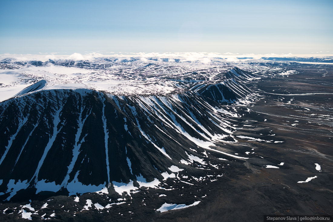
Severnaya Zemlya – the Last Major Geographical Discovery on Earth
No comments · Posted by Sergei Rzhevsky in Nature, Regions, Travel
Severnaya Zemlya (literally “Northern Land”, until 1926 – Land of Emperor Nicholas II) is an archipelago located in the central part of the Arctic Ocean north of the Taimyr Peninsula on the border of the Kara Sea and the Laptev Sea. This is the northernmost part of Krasnoyarsk Krai of Russia.
The archipelago consists of 4 large islands (October Revolution, Komsomolets, Bolshevik, Pioneer) and a number of small ones. The area of Severnaya Zemlya is about 37 thousand square km. The length from north to south is 380 km, from west to east – 340 km. There is no permanent population on the islands. Severnaya Zemlya on Google Maps. The following photographs were taken by Slava Stepanov in July.
Tags: Krasnoyarsk krai
22
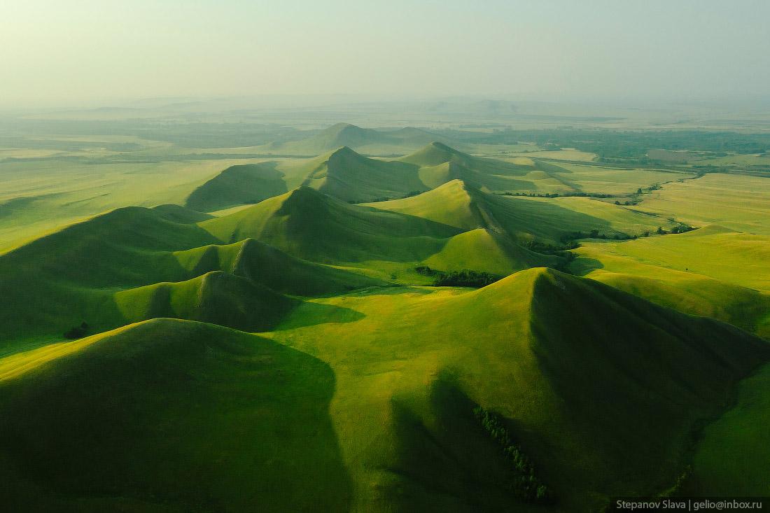
The Dolgiye Mountains – One of the Most Beautiful Places in Orenburg Oblast
No comments · Posted by Sergei Rzhevsky in Nature, Regions, Travel
The Dolgiye Mountains is one of the southern spurs of the Ural Mountains, stretching 14 km from north to south from the Ural River to the Sakmara River, on the 135th km of the Orenburg – Orsk highway.
The mountains are not high, but for the surrounding steppe terrain they look quite impressive and from a height they look like the backbone of a huge dragon. The Dolgiye Mountains on Google Maps. Photos by: Slava Stepanov.
Tags: Orenburg city · Orenburg oblast · Orsk city