
CAT | Travel
12
Gorely – One of the Most Popular Volcanoes in Kamchatka
No comments · Posted by Sergei Rzhevsky in Nature, Regions, Travel
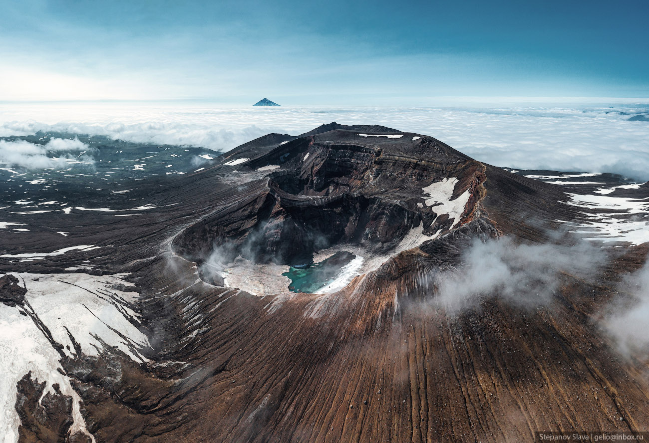
Gorely Volcano is an active volcano located about 70 km from Petropavlovsk-Kamchatsky in southern Kamchatka. This volcanic complex consists of 11 cones and 30 craters, some filled with lakes of acidic or fresh water. The volcano formed approximately 38-40 thousand years ago.
About 6,000 years ago, explosive eruptions with violent lava flows occurred here, but since the 15th century, the eruptions have become more moderate. The last recorded volcanic activity was in the summer of 2010. Gorely Volcano on Google Maps. Photos by: Slava Stepanov.

Tags: Kamchatka krai · Petropavlovsk-Kamchatsky city
12
Taymyr – the Largest Peninsula in Russia
No comments · Posted by Sergei Rzhevsky in Nature, Regions, Travel
Taymyr, the largest peninsula in Russia and the northernmost continental landmass of the Eurasian continent, is located between the Kara Sea and the Laptev Sea, on the coast of the Arctic Ocean, in the very north of Krasnoyarsk Krai.
The total area of Taymyr is about 400 thousand square kilometers, which is larger than the area of such countries as Japan (373) and Germany (357). There are no cities on the peninsula, the nearest ones are Dudinka and Norilsk located to the south of the peninsula.
The Taymyr Peninsula is located in the Arctic and subarctic zones, which determines the extreme severity of its climate. Taymyr is characterized by long cold winters with temperatures down to -62 °C and short cool summers. Snowstorms are common, sometimes lasting up to several weeks. The local population is made up of peoples of the North who roam the territory. The Taymyr Peninsula on Google Maps. Photos by: Slava Stepanov.
Tags: Krasnoyarsk krai
7
Batagaika – the Largest Permafrost Crater in the World
No comments · Posted by Sergei Rzhevsky in Nature, Regions, Travel
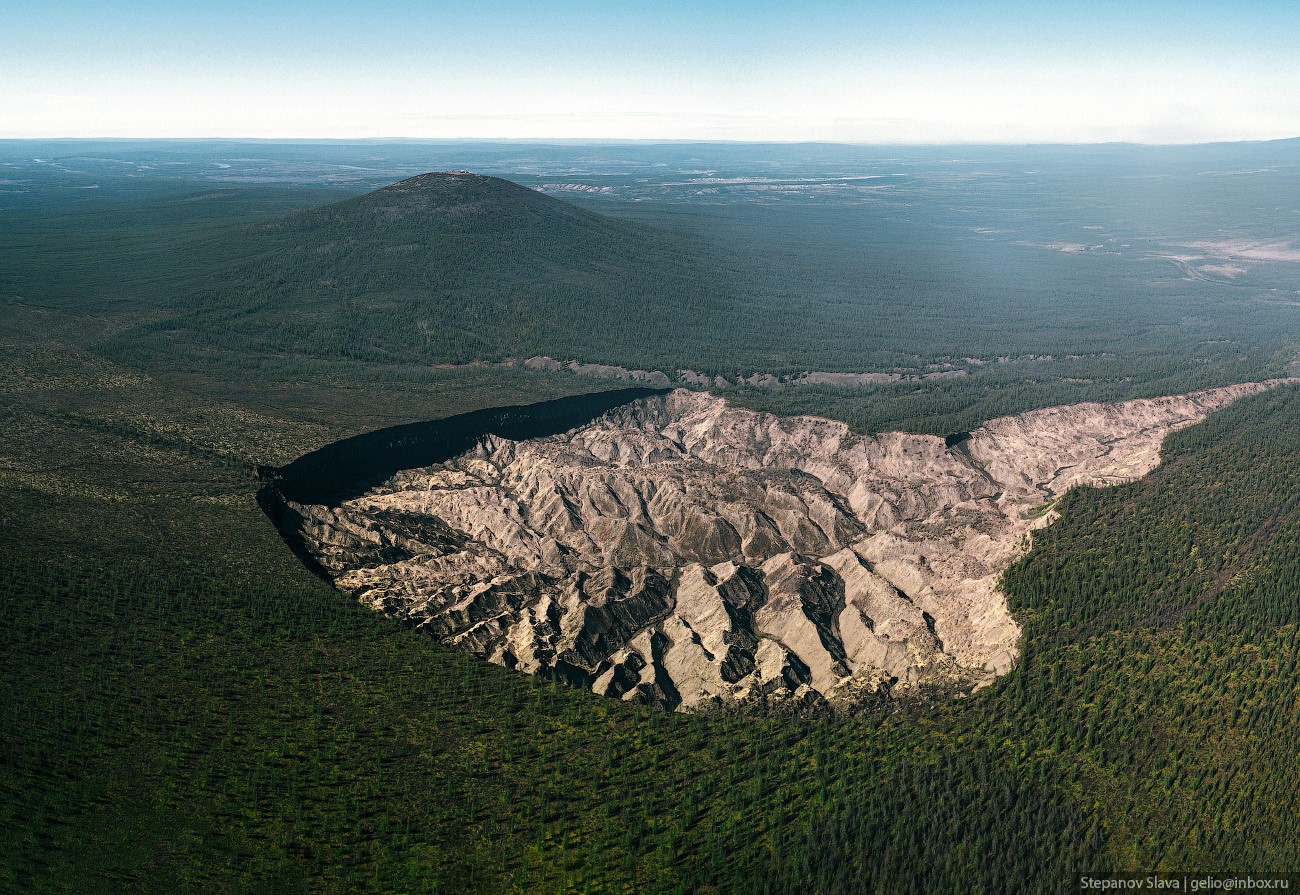
In Yakutia there is a giant thermokarst depression in the Verkhoyansk ulus (district), 10 km southeast of the village of Batagai and about 660 km north-northeast of Yakutsk. The crater is named after the nearby Batagai River.
Batagaika is about 2 km long, 1 km wide, and about 100 meters deep. Inside, remains of ancient plants, bones and tusks of mammoths, frozen bison and horses are found. This layer of ice is twice as old as the ice of Antarctica. The Batagaika Crater on Google Maps. Photos by: Slava Stepanov.
Tags: Sakha Republic · Yakutsk city
15
The Aimani-Khadzhi Kadyrova Mosque in Argun
No comments · Posted by Sergei Rzhevsky in Architecture, Religion, Travel
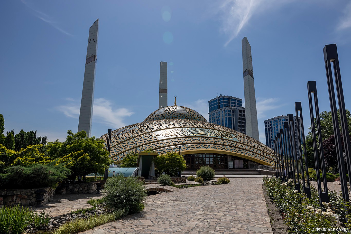
The Aimani-Khadzhi Kadyrova Mosque, also known as “The Mother’s Heart” Mosque, is located in the town of Argun in the central part of the Chechen Republic, about 15 km east of Grozny. Opened on May 16, 2014, the mosque is named after the widow of Akhmat-Khadzhi Kadyrov, the first president of the Chechen Republic.
Construction of the mosque began in the center of Argun, on the site of the former town mosque, in mid-January 2011. It was built according to the design of the Turkish architect Deniz Ceyhun Baykan. The Aimani-Khadzhi Kadyrova Mosque on Google Maps. Photos by: Alexandr Lipilin.
Tags: Chechnya Republic · Grozny city · mosque
4
Dikson – the Northernmost Settlement in Russia
No comments · Posted by Sergei Rzhevsky in Cities, Regions, Travel
Dikson is an urban-type settlement located in the very north of Krasnoyarsk Krai of Russia, on the northwestern tip of the Taimyr Peninsula, on the coast of the Kara Sea of the Arctic Ocean.
It is divided by a strait into two parts – an island and a mainland. In winter, cars and buses travel along the ice road, in summer, boats operate. In spring and autumn, you can only get from one part of the settlement to the other by helicopter. Dikson on Google Maps. Photos by: Slava Stepanov.
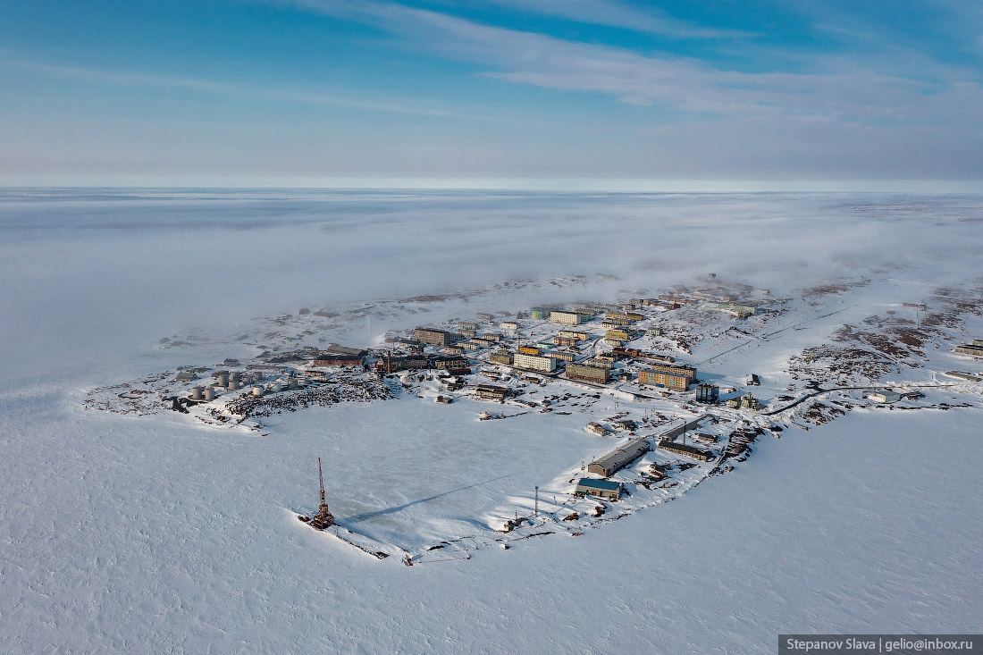
frozen settlement at the edge of the earth
Tags: Krasnoyarsk krai
28
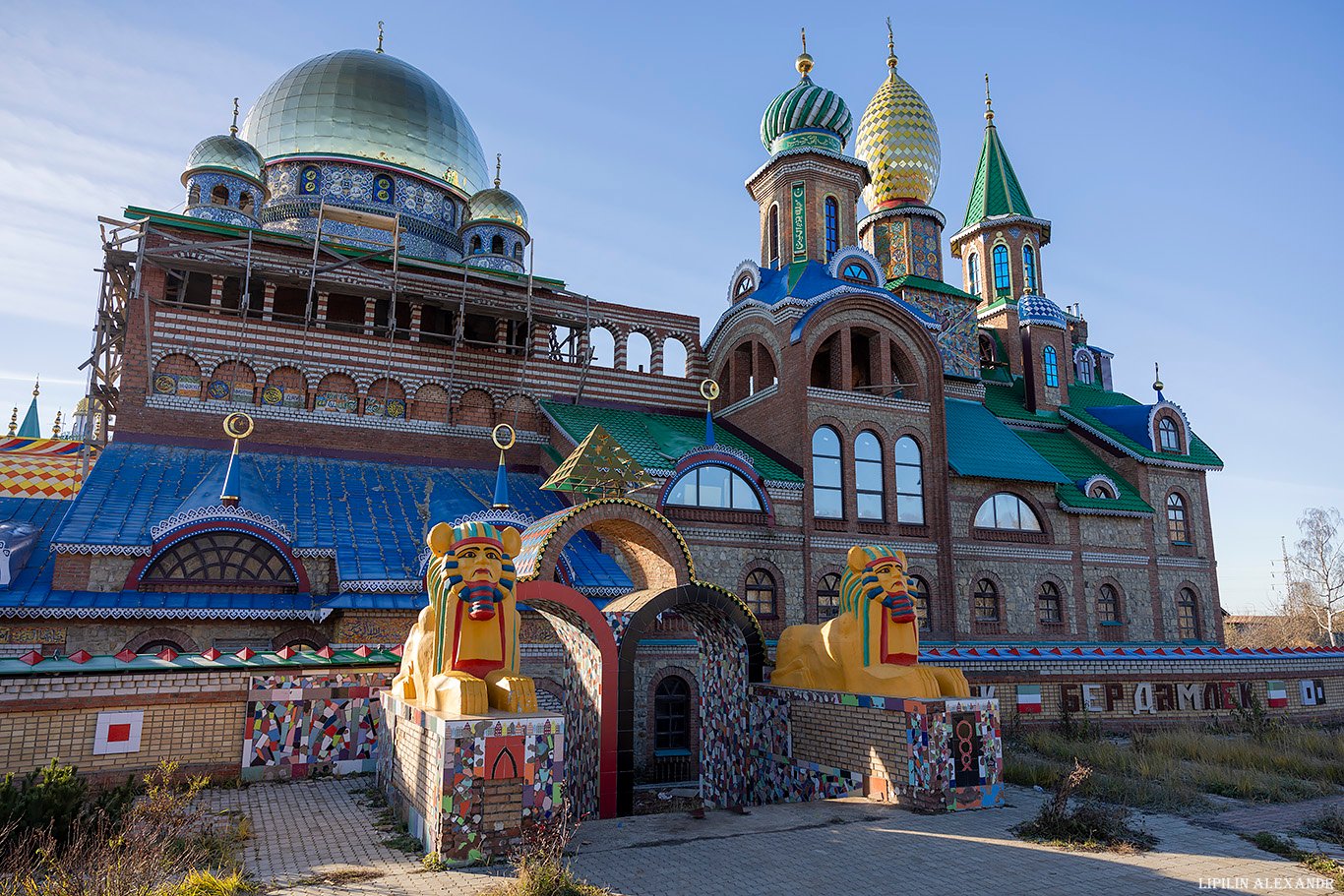
The Temple of All Religions in Kazan
No comments · Posted by Sergei Rzhevsky in Architecture, Regions, Travel
The Ecumenical Temple, also known as the Temple of All Religions and the International Cultural Center of Spiritual Unity is an architectural structure located in the Old Arakchino microdistrict in Kazan, the capital of the Republic of Tatarstan. Dedicated to various religions of the world, it is a popular landmark of the city.
The construction was started by the artist, architect, sculptor, and public figure Ildar Khanov in 1993. This idea came to him after traveling through Tibet and India. The temple was being built with the founder’s own funds until his death in 2013. After it, his brother Ilgiz and sister Flyura Galeeva continued his work.
Tags: churches · Kazan city · Tatarstan Republic
16
The Northernmost Railway in the World
1 Comment · Posted by Sergei Rzhevsky in Regions, Technology, Travel
This railway is located on the Yamal Peninsula in northern Western Siberia, in the Yamalo-Nenets Autonomous Okrug of Russia. Some of the world’s largest natural gas deposits are found here.
It consists of 5 stations and 70 bridges starting from Obskaya Station (Labytnangi) and going to Karskaya Station (the Bovanenkovo natural gas deposit). The length of the railway is 572 km, and it is located entirely beyond the Arctic Circle. Photos by: Slava Stepanov.
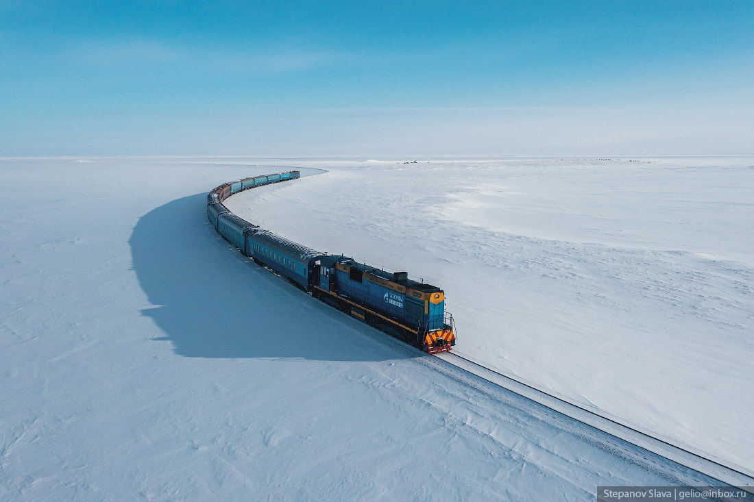
the railway at the edge of the world
Tags: Salekhard city · Yamalo-Nenets okrug
3
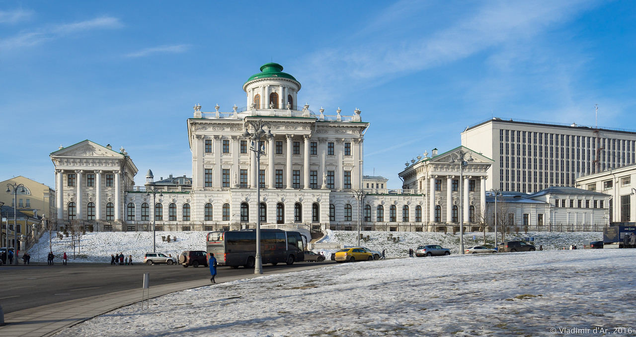
The Pashkov House – One of the Best Buildings in Moscow
No comments · Posted by Sergei Rzhevsky in Architecture, Cities, Travel
The Pashkov House is one of the most famous neoclassical buildings in Moscow. Today, it belongs to the Russian State Library. The building is located on a hill overlooking the western wall of the Moscow Kremlin, at Vozdvizhenka Street, 3/5, building 1.
This architectural monument, built by order of the captain of Semyonovsky life-guards regiment Peter Pashkov in 1784-1786, was designed presumably by the architect Vasily Bazhenov. The Pashkov House on Google Maps. Photos by: Vladimir d’Ar.
Tags: Moscow city
10
Putorana Plateau – the Mountains with Flat Tops
No comments · Posted by Sergei Rzhevsky in Nature, Regions, Travel
Putorana is a strongly dissected mountain range located in the northwest of Krasnoyarsk Krai. The nearest large settlement is the city of Norilsk. The surface of the plateau is covered with basaltic lava flows often referred to as the Siberian Traps. This is one of the most poorly studied and inaccessible regions of Russia.
The maximum height of the plateau is 1,701 meters. The name “Putorana”, translated from Evenki, means “lakes with steep banks”. The plateau area is about 250,000 square kilometers. The Putoransky Nature Reserve, recognized by UNESCO as a World Heritage Site, is located on the plateau. The Putorana Plateau on Google Maps. Photos by: Slava Stepanov.
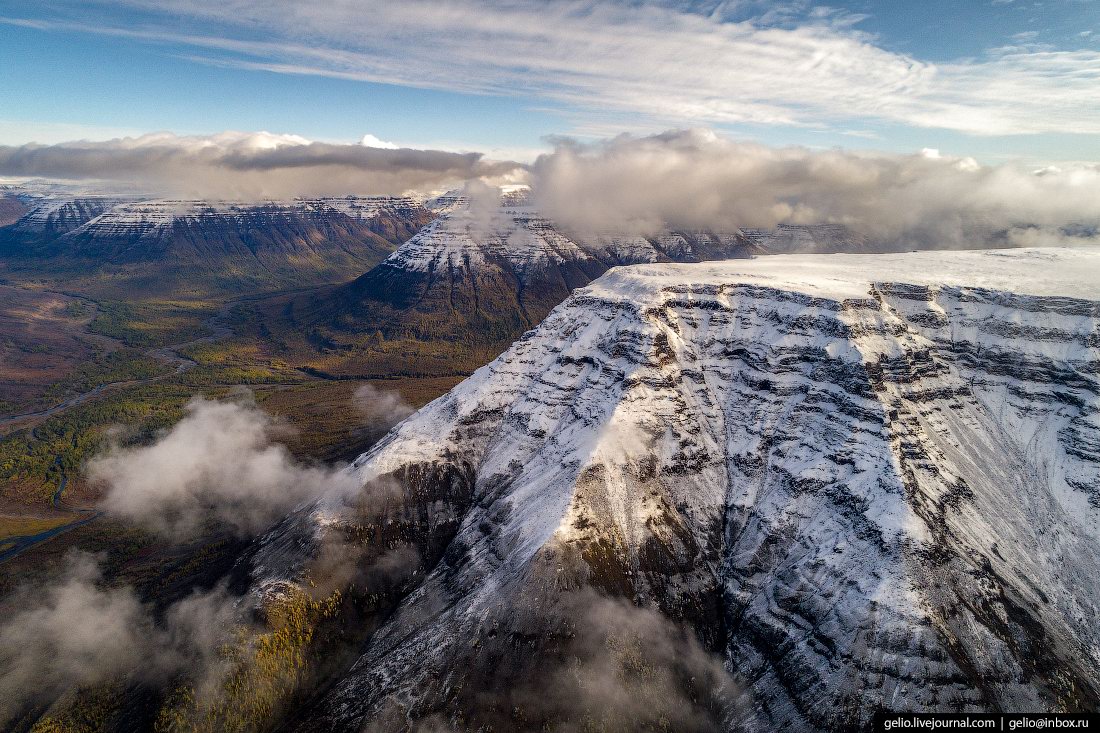
Tags: Krasnoyarsk krai · Norilsk city
13
Autumn in the Ruskeala Mountain Park
No comments · Posted by Sergei Rzhevsky in Nature, Regions, Travel
The mountain park “Ruskeala” is a tourist complex located in the Sortavala district of the Republic of Karelia, near the border with Finland. The basis of the complex is an abandoned marble quarry filled with groundwater – a cultural heritage site and historic monument.
The park is located near the village of Ruskeala, about 30 kilometers north of the town of Sortavala. The length of the former marble quarry from north to south is 460 meters, the width – up to 100 meters. Ruskeala Park on Google Maps. Photos by: Maria Mitrofanova.
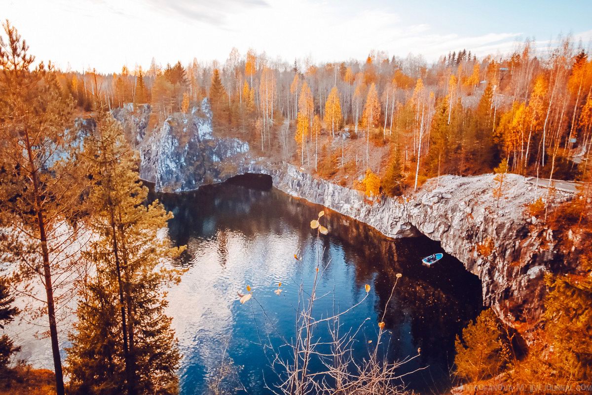
Tags: Abandoned · Karelia Republic · Petrozavodsk city