
CAT | Regions
12
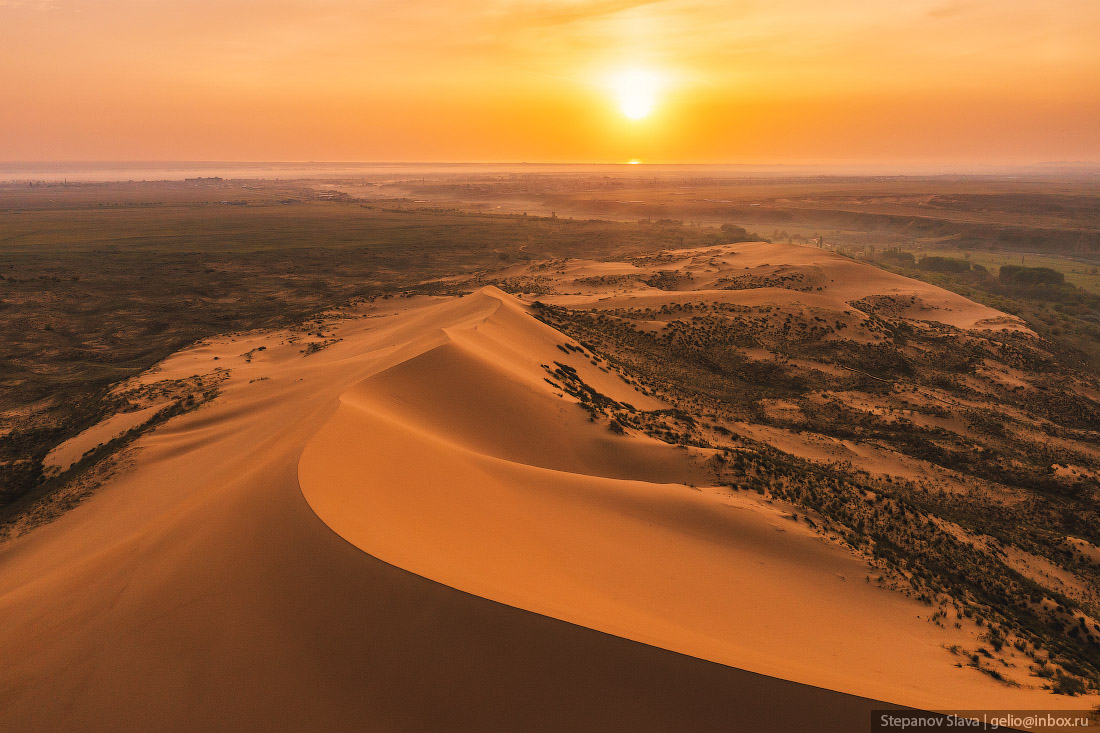
Sarykum – the Largest Sand Dune in Europe
No comments · Posted by Sergei Rzhevsky in Nature, Regions, Travel
Sarykum or Sary-Kum (translated from the Kumyk language as “Yellow Sand”) is the largest sand dune in Europe, located in the central part of the Republic of Dagestan, about 18 km northwest of Makhachkala. It is one of the largest sand dunes in Eurasia, approximately 3 km long, 2 km wide and up to 262 meters high.
The dune is located in a protected area, part of the Dagestan Nature Reserve, created on January 9, 1987. In 1968, several scenes of the famous Soviet movie “White Sun of the Desert” were filmed here. The Sarykum Sand Dune on Google Maps. Photos by: Slava Stepanov.

Tags: Dagestan Republic · Makhachkala city
26
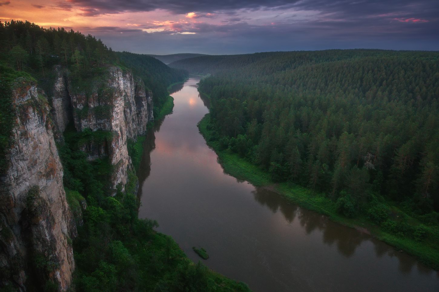
Magnificent Landscapes of Ayskiye Pritosy
No comments · Posted by Sergei Rzhevsky in Nature, Regions, Travel
The Ay River is the largest tributary of the Ufa River and one of the most picturesque places in the Southern Urals. Ayskiye Pritosy is a unique natural geological object located on the Ay River, on the border of Chelyabinsk Oblast and the Republic of Bashkortostan.
These beautiful limestone cliffs, which are steep walls up to 90 meters high, consist of two groups – Bol’shiye (Big) Pritosy and Malye (Small) Pritosy. In the local dialect, Ayskiye Pritosy is called “Sybar-kaya”, which in translation from Bashkir language means “multi-colored cliff”. Ayskiye Pritosy on Google Maps. Photos by: Vladimir Lyapin.
amazing natural monument of the Southern Urals
Tags: Bashkortostan Republic · Chelyabinsk oblast
9
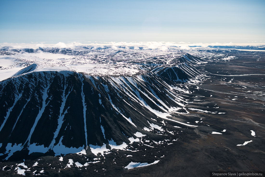
Severnaya Zemlya – the Last Major Geographical Discovery on Earth
No comments · Posted by Sergei Rzhevsky in Nature, Regions, Travel
Severnaya Zemlya (literally “Northern Land”, until 1926 – Land of Emperor Nicholas II) is an archipelago located in the central part of the Arctic Ocean north of the Taimyr Peninsula on the border of the Kara Sea and the Laptev Sea. This is the northernmost part of Krasnoyarsk Krai of Russia.
The archipelago consists of 4 large islands (October Revolution, Komsomolets, Bolshevik, Pioneer) and a number of small ones. The area of Severnaya Zemlya is about 37 thousand square km. The length from north to south is 380 km, from west to east – 340 km. There is no permanent population on the islands. Severnaya Zemlya on Google Maps. The following photographs were taken by Slava Stepanov in July.
Tags: Krasnoyarsk krai
22
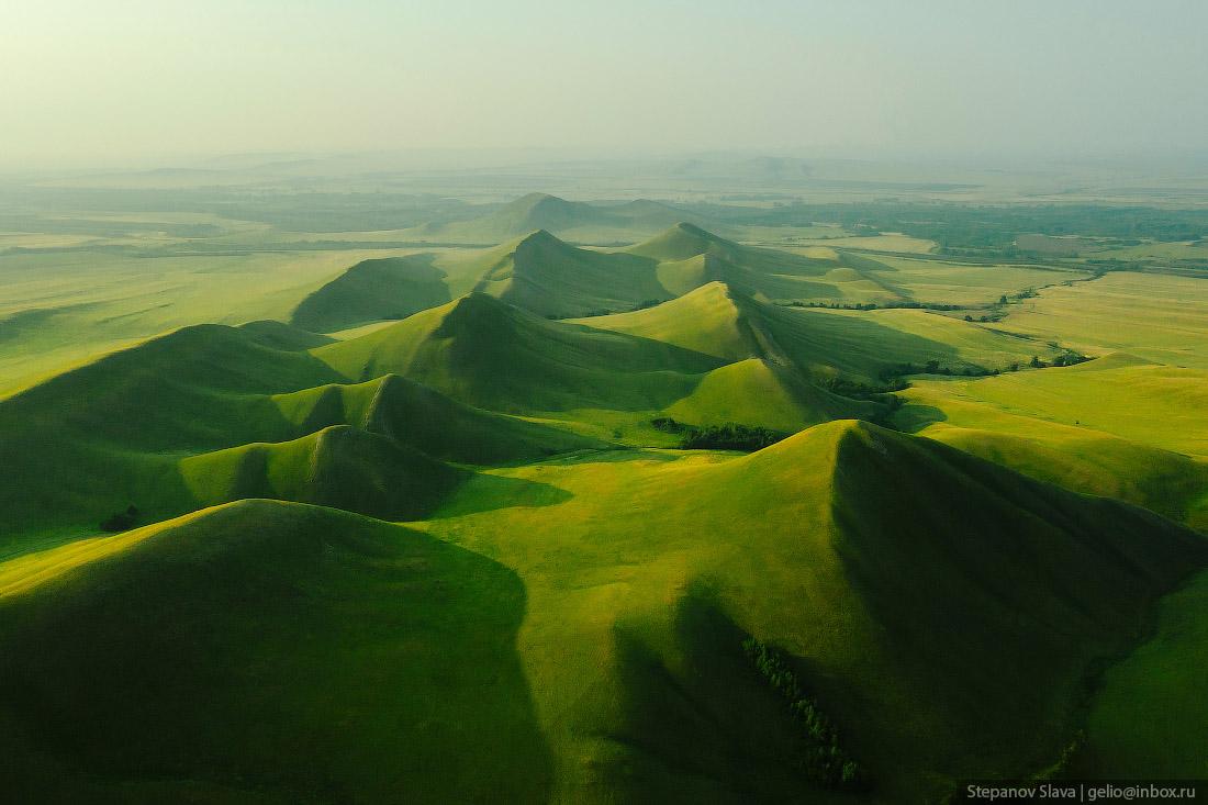
The Dolgiye Mountains – One of the Most Beautiful Places in Orenburg Oblast
No comments · Posted by Sergei Rzhevsky in Nature, Regions, Travel
The Dolgiye Mountains is one of the southern spurs of the Ural Mountains, stretching 14 km from north to south from the Ural River to the Sakmara River, on the 135th km of the Orenburg – Orsk highway.
The mountains are not high, but for the surrounding steppe terrain they look quite impressive and from a height they look like the backbone of a huge dragon. The Dolgiye Mountains on Google Maps. Photos by: Slava Stepanov.
Tags: Orenburg city · Orenburg oblast · Orsk city
27
Amazing Church of the Transfiguration in Krasnoye in Tver Oblast
No comments · Posted by Sergei Rzhevsky in Architecture, Regions, Travel
The Church of the Transfiguration of the Lord (1790) is an architectural monument of federal significance located in the village of Krasnoye in the central part of Tver Oblast of Russia. This picturesque church built in a pseudo-Gothic style is an almost exact copy of the Chesme Church in St. Petersburg (1780).
The height of the building is 24 meters, length and width are about 20 m. This red church looks especially unusual in winter against the backdrop of farmhouses and barns.

Tags: churches · Tver oblast
11
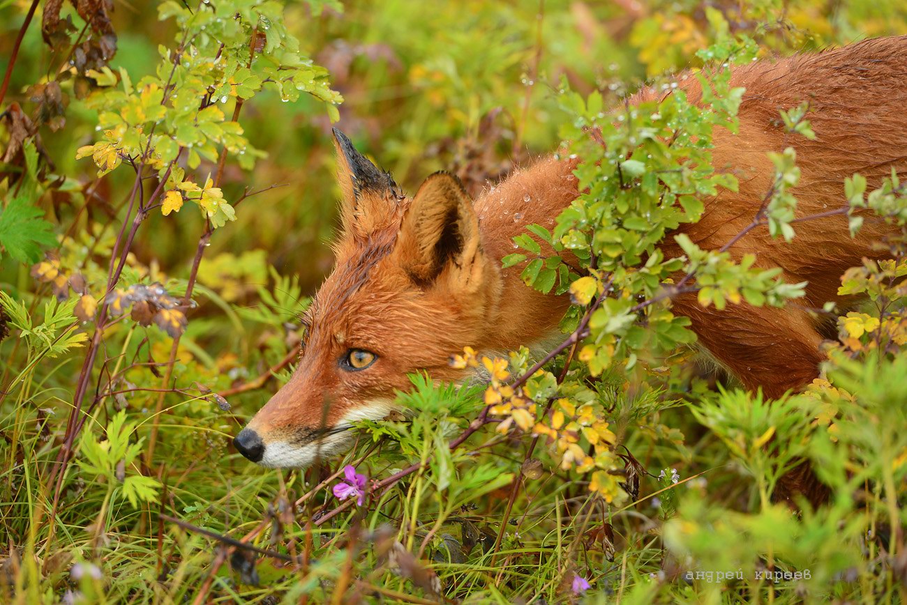
Kamchatka – the Land of Bears and Foxes
No comments · Posted by Sergei Rzhevsky in Nature, Photos, Regions
Kamchatka, a peninsula in Russia, is located in the north-eastern part of Eurasia. The peninsula, stretching from north to south for 1,200 km, is washed by the Sea of Okhotsk in the west, the Bering Sea and the Pacific Ocean in the east. The total area of Kamchatka is about 270 thousand square km.
A significant part of the territory of the Kamchatka Peninsula is allocated to specially protected areas. Among them are 3 state reserves, 5 natural parks, 8 federal and 23 local reserves, 105 natural monuments, 2 sanatorium-resort areas, and some other types of protected areas. The most photogenic representatives of the local fauna are numerous bears and foxes. Photos by: Andrei Kireev.
the beauty of untouched nature
Tags: Kamchatka krai
15
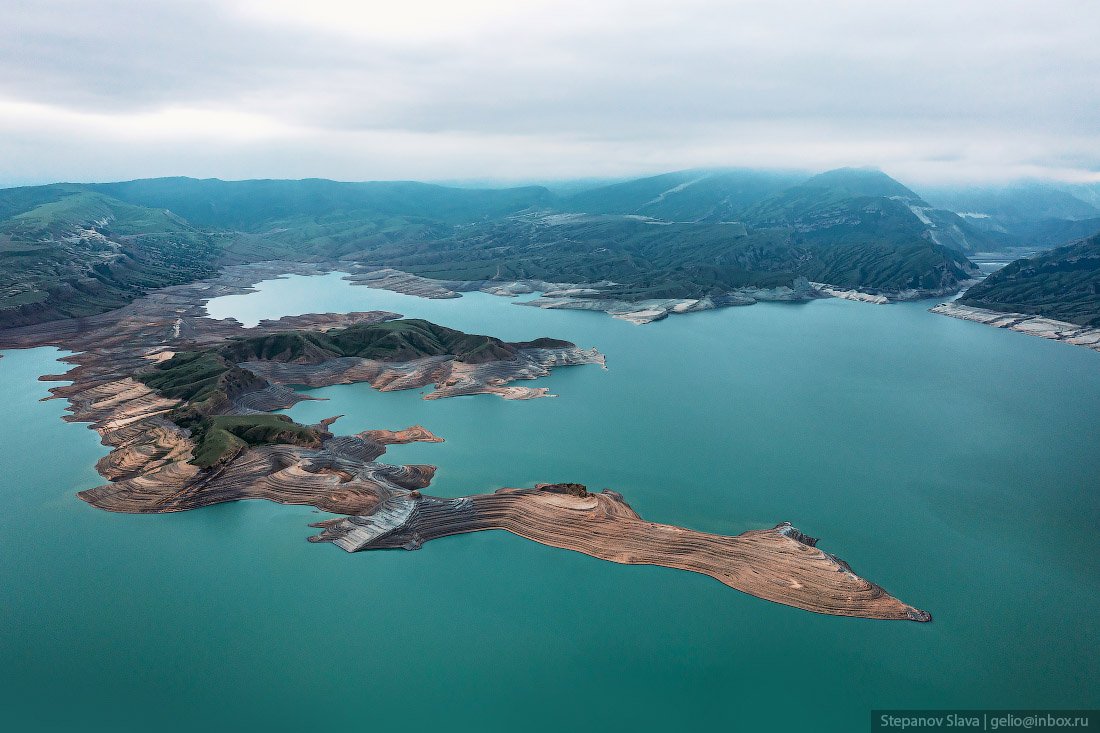
Chirkey Reservoir – the largest in the North Caucasus
No comments · Posted by Sergei Rzhevsky in Nature, Regions, Travel
Chirkey Reservoir, the largest reservoir in the North Caucasus, is located in the central part of the Republic of Dagestan. It was formed on the Sulak River as a result of the construction of the Chirkey hydroelectric power station.
The reservoir is also used for fishing and water supply. Its height above sea level is 335 m. The water surface area is 42.4 square km, the volume – 2.78 cubic km. The greatest depth is 220 m. The width of the reservoir exceeds 5 km. Chirkey Reservoir on Google Maps. Photos by: Slava Stepanov.
Tags: Dagestan Republic · Makhachkala city
31
Gorokhovets – a picturesque historical town in Vladimir Oblast
No comments · Posted by Sergei Rzhevsky in Regions, Travel
Gorokhovets, founded in 1168, is a small town with a population of about 12 thousand people located in the eastern part of Vladimir Oblast in the center of European Russia, about 159 km east of Vladimir and 86 km west of Nizhny Novgorod.
One of the oldest towns in the region, Gorokhovets is included in the list of historical settlements of Russia. On the territory of the town and its environs, a lot of monuments of church and civil architecture from different eras have been preserved. Gorokhovets on Google Maps. Photos by: Yuliya Baturina.
Cathedral of the Annunciation (1700) in Gorokhovets.

beautiful architecture of provincial Russia
Tags: Vladimir oblast
6
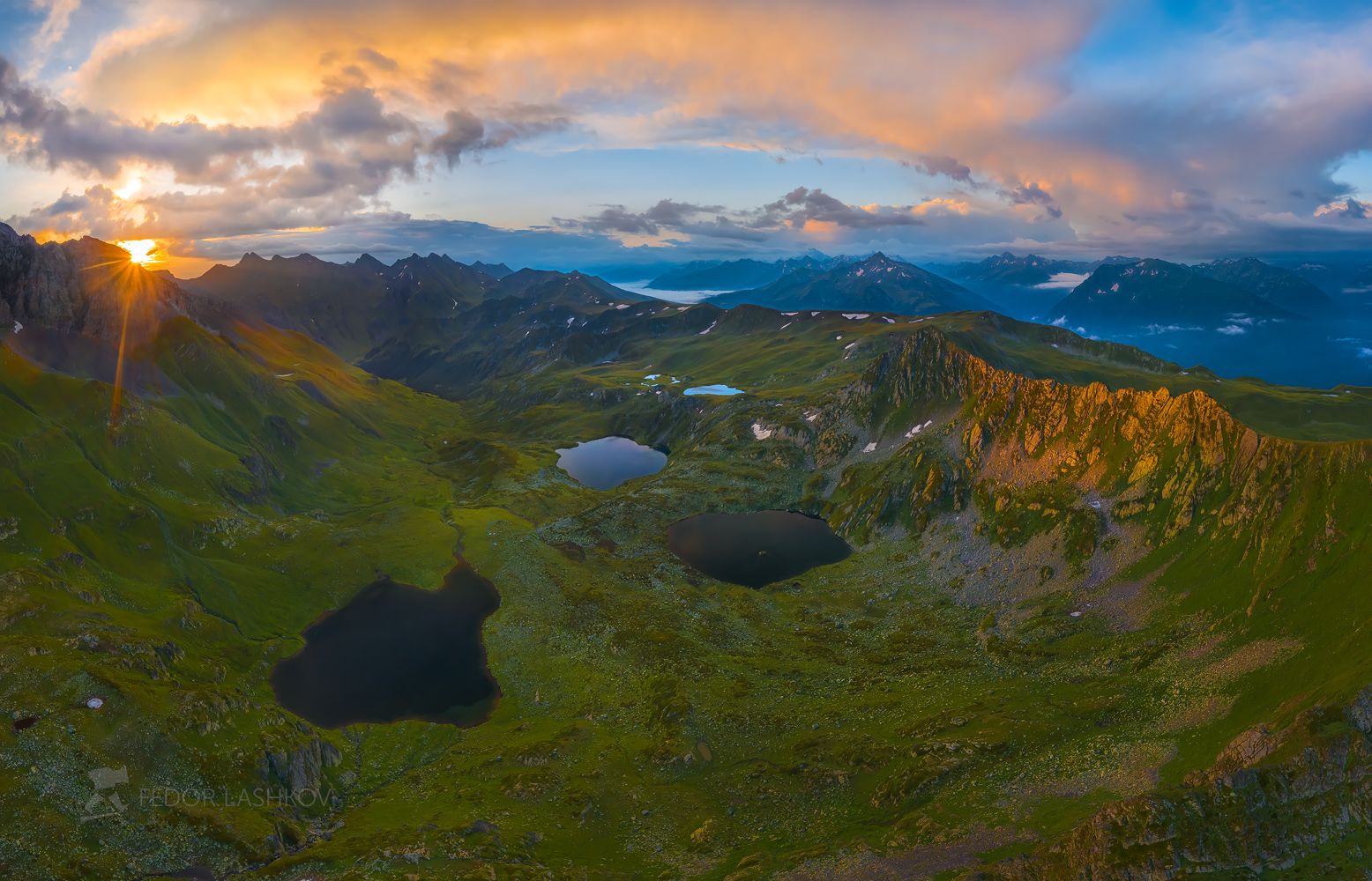
Atsgara Lakes in Karachay-Cherkessia
No comments · Posted by Sergei Rzhevsky in Nature, Regions, Travel
Atsgara lakes or the Pyatiozerye (“Five lakes”) valley are located at an altitude of about 2,500 meters above sea level in the Urupsky district of the Republic of Karachay-Cherkessia, about 26 km northwest of the village of Arkhyz and 7 km east of the village of Zagedan.
In total, there are more than 10 lakes here, but only 5 are large in size, their length is about 200-350 meters. The lakes are located on mountain terraces formed by an ancient glacier and at different heights relative to each other. In summer, these lakes warm up quite well and you can cool off in them. Atsgara Lakes in Karachay-Cherkessia on Google Maps. Photos by: Fedor Lashkov.
Tags: Cherkessk city · Karachay-Cherkessia Republic
19
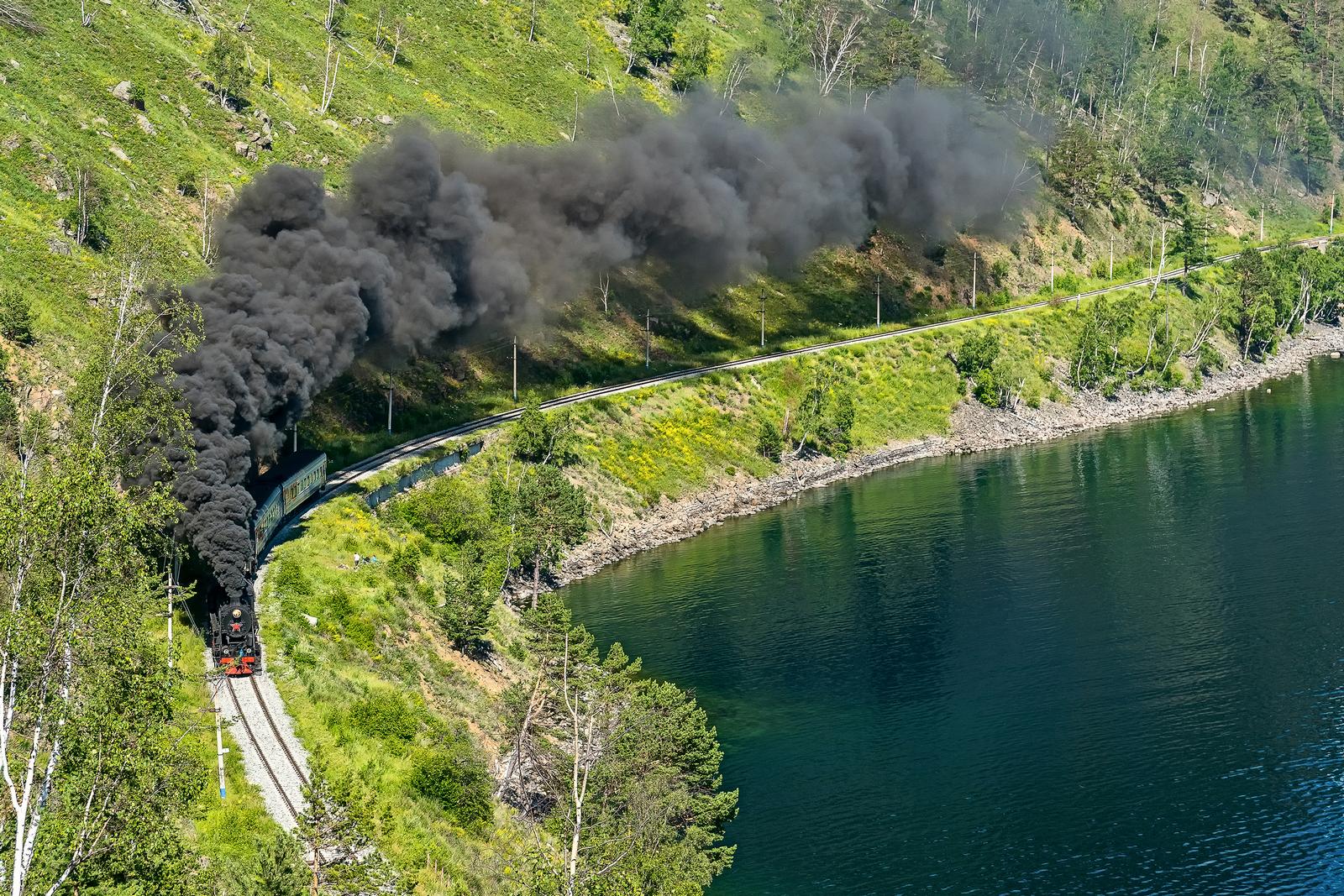
Steam Locomotive of the Circum-Baikal Railway
No comments · Posted by Sergei Rzhevsky in Entertainment, Regions, Travel
The Circum-Baikal Railway is the name used during the construction (1899-1905) and in the first years of operation of the 260 km section of the Trans-Baikal Railway. Today, this is a dead end section of Slyudyanka II – Baikal, 89 kilometers long. It is located about 70 km south of Irkutsk and runs along the shore of Lake Baikal.
This railroad has no equal in Russia by the number of engineering structures. Its tunnels and stone galleries are unique. Built according to non-standard projects, they were not rebuilt in subsequent years, retaining the original plan of architects and engineers of the early 20th century. Photos by: Mikhail Tilpunov.
Tags: Irkutsk oblast · Russian Empire