
CAT | Travel
14
Beautiful Landscapes of Iturup Island
No comments · Posted by Sergei Rzhevsky in Nature, Travel
Iturup is an island of the southern group of the Great Ridge of the Kuril Islands, the largest island of the archipelago, part of Sakhalin Oblast, Russia. The island is disputed by Japan, which considers it as part of Nemuro Subprefecture of Hokkaido Prefecture.
According to the most common version, the name of this island goes back to the word “etorop”, which is translated from the Ainu language as “jellyfish”. In 2023, the population of the island was about 6,900 people. Iturup Island on Google Maps. Photos by: Andrey Grachev.


Tags: Sakhalin oblast
10
Where to Play Poker Malaysia
No comments · Posted by Sergei Rzhevsky in Entertainment, Travel
Discover vibrant poker scenes in Kuala Lumpur, Penang, Johor Bahru, Malacca, and Genting Highlands, offering competitive tournaments, diverse game options, and luxurious settings. From upscale poker rooms in city centers to high-stakes experiences with panoramic views, Malaysia caters to all levels of players. The thriving poker culture in different regions provides unique opportunities for immersive gaming experiences and professional tournament structures. Explore these top destinations to elevate your poker gameplay and immerse yourself in the excitement of Malaysia’s diverse poker landscape.

Photo by Michał Parzuchowski on Unsplash
Tags: No tags
9
Severnaya Zemlya – the Last Major Geographical Discovery on Earth
No comments · Posted by Sergei Rzhevsky in Nature, Regions, Travel
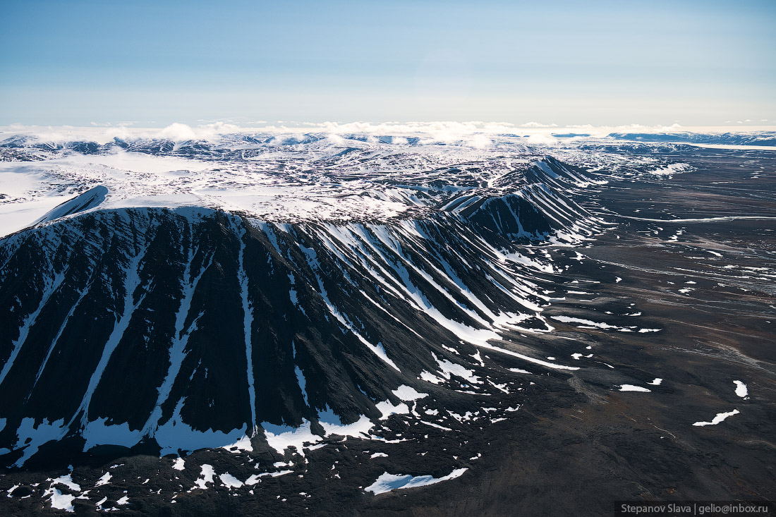
Severnaya Zemlya (literally “Northern Land”, until 1926 – Land of Emperor Nicholas II) is an archipelago located in the central part of the Arctic Ocean north of the Taimyr Peninsula on the border of the Kara Sea and the Laptev Sea. This is the northernmost part of Krasnoyarsk Krai of Russia.
The archipelago consists of 4 large islands (October Revolution, Komsomolets, Bolshevik, Pioneer) and a number of small ones. The area of Severnaya Zemlya is about 37 thousand square km. The length from north to south is 380 km, from west to east – 340 km. There is no permanent population on the islands. Severnaya Zemlya on Google Maps. The following photographs were taken by Slava Stepanov in July.
Tags: Krasnoyarsk krai
22
The Dolgiye Mountains – One of the Most Beautiful Places in Orenburg Oblast
No comments · Posted by Sergei Rzhevsky in Nature, Regions, Travel
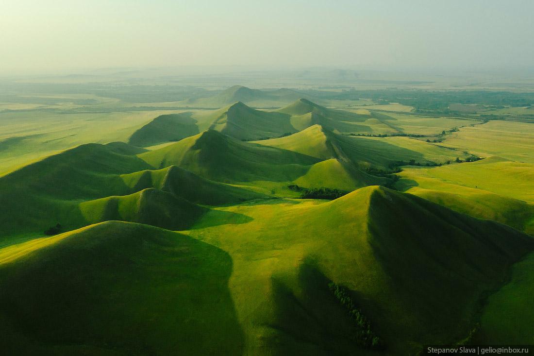
The Dolgiye Mountains is one of the southern spurs of the Ural Mountains, stretching 14 km from north to south from the Ural River to the Sakmara River, on the 135th km of the Orenburg – Orsk highway.
The mountains are not high, but for the surrounding steppe terrain they look quite impressive and from a height they look like the backbone of a huge dragon. The Dolgiye Mountains on Google Maps. Photos by: Slava Stepanov.
Tags: Orenburg city · Orenburg oblast · Orsk city
13
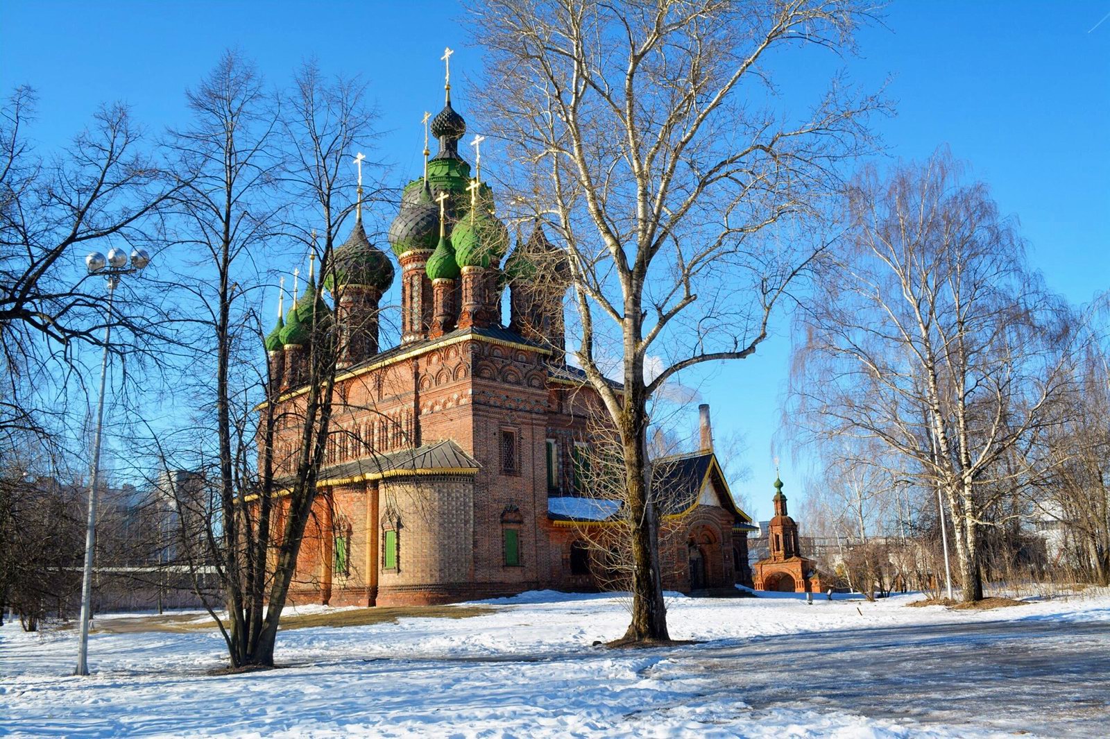
Unique 15-domed Church of St. John the Baptist in Yaroslavl
No comments · Posted by Sergei Rzhevsky in Architecture, Religion, Travel
The Church of John the Baptist in Yaroslavl is an inactive Orthodox church, a unique monument of Russian architecture of the 17th century and one of the most famous works of the Yaroslavl school of architecture during its peak period. It is located in the southern part of Yaroslavl, on the right bank of the Kotorosl River.
This church is a monument of history and culture of world importance included in the UNESCO cultural heritage list. It was built in 1671-1687. Its 45-meter bell tower was built in the Moscow Baroque style in 1690. This is the only church in Russia with fifteen domes, divided into three groups.
Tags: churches · Yaroslavl city
27
Amazing Church of the Transfiguration in Krasnoye in Tver Oblast
No comments · Posted by Sergei Rzhevsky in Architecture, Regions, Travel
The Church of the Transfiguration of the Lord (1790) is an architectural monument of federal significance located in the village of Krasnoye in the central part of Tver Oblast of Russia. This picturesque church built in a pseudo-Gothic style is an almost exact copy of the Chesme Church in St. Petersburg (1780).
The height of the building is 24 meters, length and width are about 20 m. This red church looks especially unusual in winter against the backdrop of farmhouses and barns.

Tags: churches · Tver oblast
15
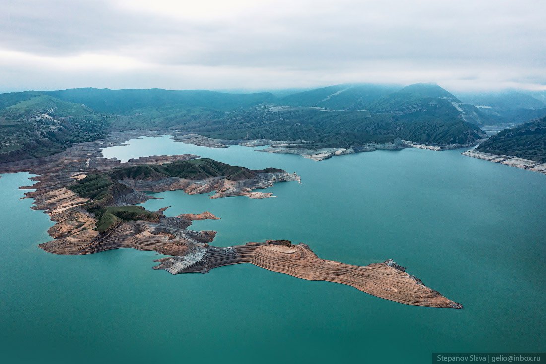
Chirkey Reservoir – the largest in the North Caucasus
No comments · Posted by Sergei Rzhevsky in Nature, Regions, Travel
Chirkey Reservoir, the largest reservoir in the North Caucasus, is located in the central part of the Republic of Dagestan. It was formed on the Sulak River as a result of the construction of the Chirkey hydroelectric power station.
The reservoir is also used for fishing and water supply. Its height above sea level is 335 m. The water surface area is 42.4 square km, the volume – 2.78 cubic km. The greatest depth is 220 m. The width of the reservoir exceeds 5 km. Chirkey Reservoir on Google Maps. Photos by: Slava Stepanov.
Tags: Dagestan Republic · Makhachkala city
31
Gorokhovets – a picturesque historical town in Vladimir Oblast
No comments · Posted by Sergei Rzhevsky in Regions, Travel
Gorokhovets, founded in 1168, is a small town with a population of about 12 thousand people located in the eastern part of Vladimir Oblast in the center of European Russia, about 159 km east of Vladimir and 86 km west of Nizhny Novgorod.
One of the oldest towns in the region, Gorokhovets is included in the list of historical settlements of Russia. On the territory of the town and its environs, a lot of monuments of church and civil architecture from different eras have been preserved. Gorokhovets on Google Maps. Photos by: Yuliya Baturina.
Cathedral of the Annunciation (1700) in Gorokhovets.

beautiful architecture of provincial Russia
Tags: Vladimir oblast
6
Atsgara Lakes in Karachay-Cherkessia
No comments · Posted by Sergei Rzhevsky in Nature, Regions, Travel
Atsgara lakes or the Pyatiozerye (“Five lakes”) valley are located at an altitude of about 2,500 meters above sea level in the Urupsky district of the Republic of Karachay-Cherkessia, about 26 km northwest of the village of Arkhyz and 7 km east of the village of Zagedan.
In total, there are more than 10 lakes here, but only 5 are large in size, their length is about 200-350 meters. The lakes are located on mountain terraces formed by an ancient glacier and at different heights relative to each other. In summer, these lakes warm up quite well and you can cool off in them. Atsgara Lakes in Karachay-Cherkessia on Google Maps. Photos by: Fedor Lashkov.
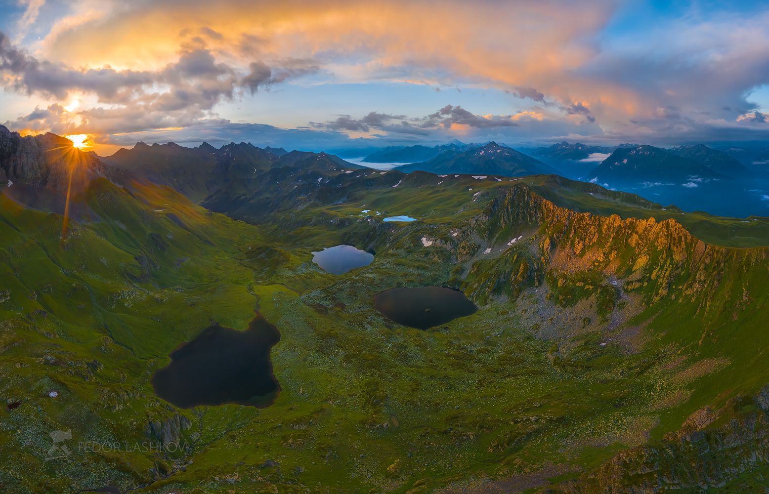
Tags: Cherkessk city · Karachay-Cherkessia Republic
19
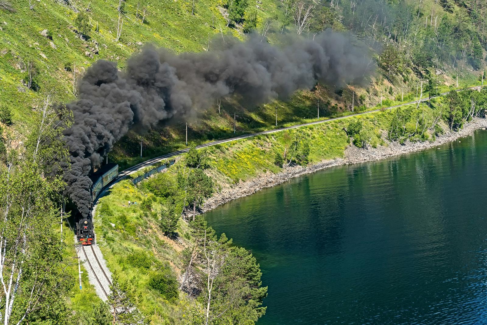
Steam Locomotive of the Circum-Baikal Railway
No comments · Posted by Sergei Rzhevsky in Entertainment, Regions, Travel
The Circum-Baikal Railway is the name used during the construction (1899-1905) and in the first years of operation of the 260 km section of the Trans-Baikal Railway. Today, this is a dead end section of Slyudyanka II – Baikal, 89 kilometers long. It is located about 70 km south of Irkutsk and runs along the shore of Lake Baikal.
This railroad has no equal in Russia by the number of engineering structures. Its tunnels and stone galleries are unique. Built according to non-standard projects, they were not rebuilt in subsequent years, retaining the original plan of architects and engineers of the early 20th century. Photos by: Mikhail Tilpunov.
Tags: Irkutsk oblast · Russian Empire