
CAT | Regions
22
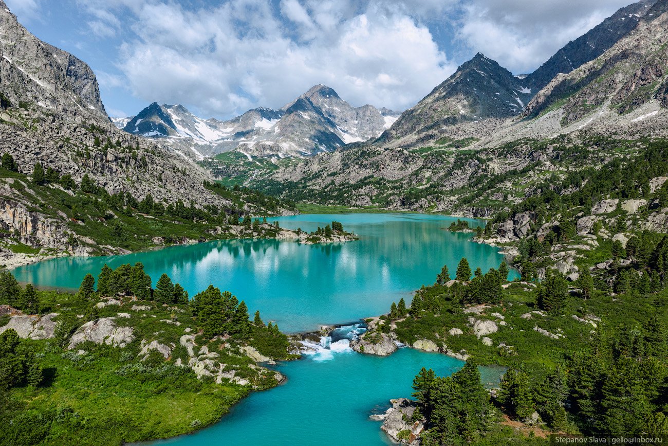
Lake Darashkol – the Hidden Treasure of Altai
No comments · Posted by Sergei Rzhevsky in Nature, Regions, Travel
Darashkol (in the Altai language “Dyarash Kol” means “beautiful lake”) is a glacial high-altitude lake (2,133 meters above sea level) located in the Altai Mountains in the southern part of the Altai Republic in Western Siberia.
The lake is situated on the territory of the Belukha Nature Park, which also includes the Kucherlinskoye and Akkemskoye lakes, and is a UNESCO World Cultural and Natural Heritage Site. Lake Darashkol on Google Maps. Photos by: Slava Stepanov.

Tags: Altay Republic
7
Unique Color Panoramas of the Russian Empire
No comments · Posted by Sergei Rzhevsky in History, Photos, Regions
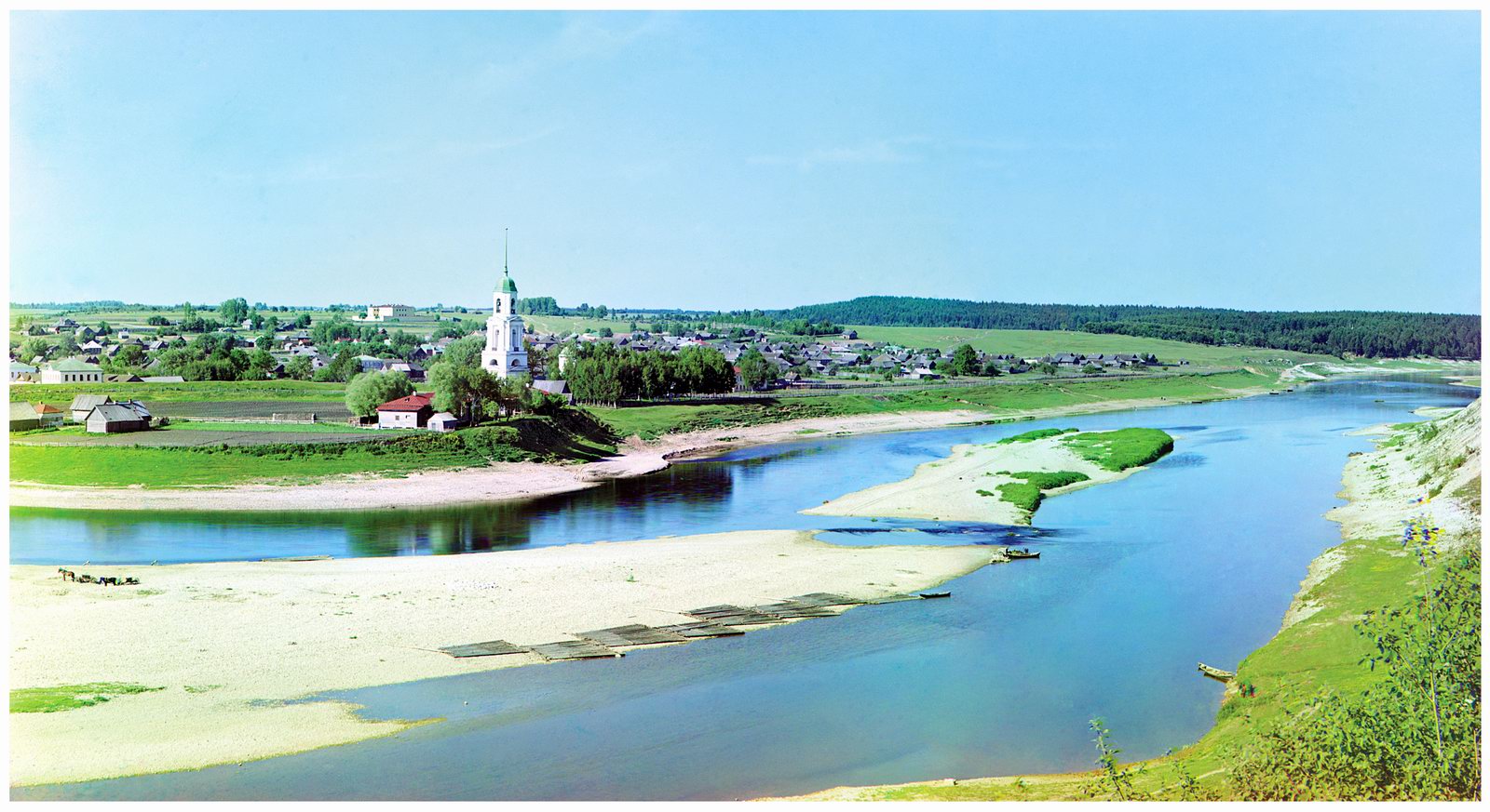
Sergei Mikhailovich Prokudin-Gorsky (1863-1944) was a Russian photographer, chemist (a student of Dmitri Mendeleev), inventor, publisher, teacher, and public figure. He made significant contributions to the development of photography and cinematography. He was a pioneer of color photography in Russia and the creator of the “Collection of Landmarks of the Russian Empire.”
Between 1909 and 1916, Prokudin-Gorsky traveled across a significant portion of the Russian Empire, photographing old churches, monasteries, factories, towns, villages, and a variety of everyday scenes.
The town of Zubtsov (Tver Oblast) on the Volga River (1910).
the last years of the Russian Empire
Tags: Russian Empire
8
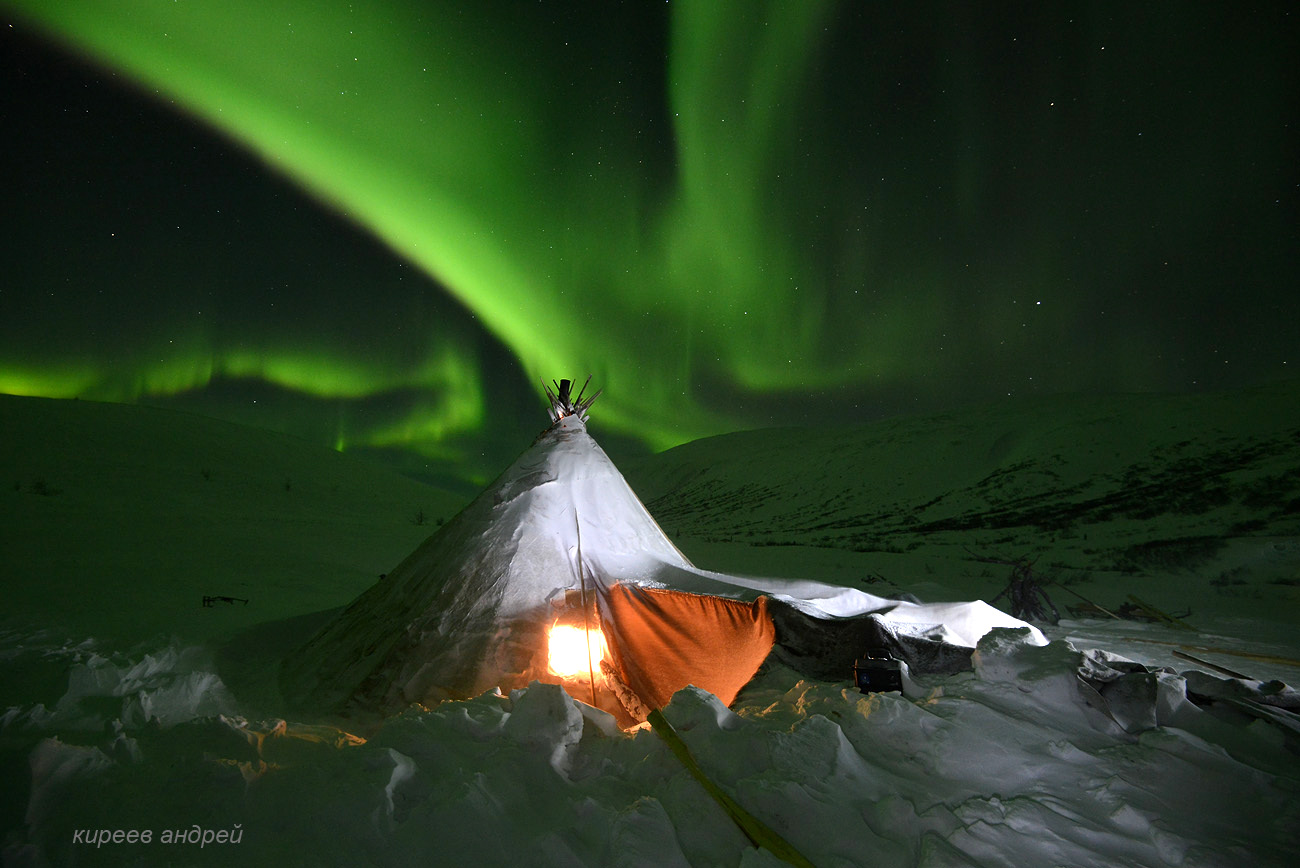
The Life of the Nenets Reindeer Herders in Yamal
No comments · Posted by Sergei Rzhevsky in People, Regions, Society
Yamal is a peninsula located in the north of Western Siberia, on the territory of the Yamal-Nenets Autonomous District. The landscapes of the peninsula are predominantly tundra with numerous lakes. The length of the peninsula is 700 km, the width is up to 240 km. The word “Yamal” is translated from Nenets as “edge of the earth”.
This part of Russia is underdeveloped in terms of population. The Nenets, the indigenous people of Yamal, engage in traditional activities such as large-scale reindeer herding, fishing, and hunting. According to the 2021 census, the total number of Nenets is approximately 35-36 thousand people. Yamal on Google Maps. Photos by: Andrei Kireev.
The northern lights and a typical Nenets tent made of untreated leather. The air temperature was minus 30 degrees Celsius.
the harsh life of reindeer herders
Tags: Tyumen oblast · Yamalo-Nenets okrug
28
The Highest Island in Russia
No comments · Posted by Sergei Rzhevsky in Nature, Regions, Travel
Atlasov Island, located 70 km south of Kamchatka, is the northernmost island of the Kuril Islands of Sakhalin Oblast. It is the surface portion of the Alaid volcano, whose eruptions led to the formation of the highest island in Russia and the 50th highest in the world.
The island is nearly round, with a diameter in the range of 13-17 km. The volcano is located exactly in the center, and the cone rises to over 2,300 meters. Rain clouds form lower down, so the summit is often hidden by clouds. Atlasov Island on Google Maps. Photos by: Slava Stepanov.

Tags: Sakhalin oblast · Yuzhno-Sakhalinsk city
22
Winter in the Museum of the Russian North “Malye Korely”
No comments · Posted by Sergei Rzhevsky in Architecture, Regions, Travel
“Malye Korely” is an open-air museum-reserve of traditional Russian wooden buildings of Arkhangelsk Oblast located in a forested area near the village of Malye Karely in the Primorsky District of Arkhangelsk Oblast, 25 km south of central Arkhangelsk, near the right bank of the Northern Dvina River.
This museum covering an area of 139.8 hectares is a popular tourist destination in the region. It is one of the largest landscape exhibitions in Russia.
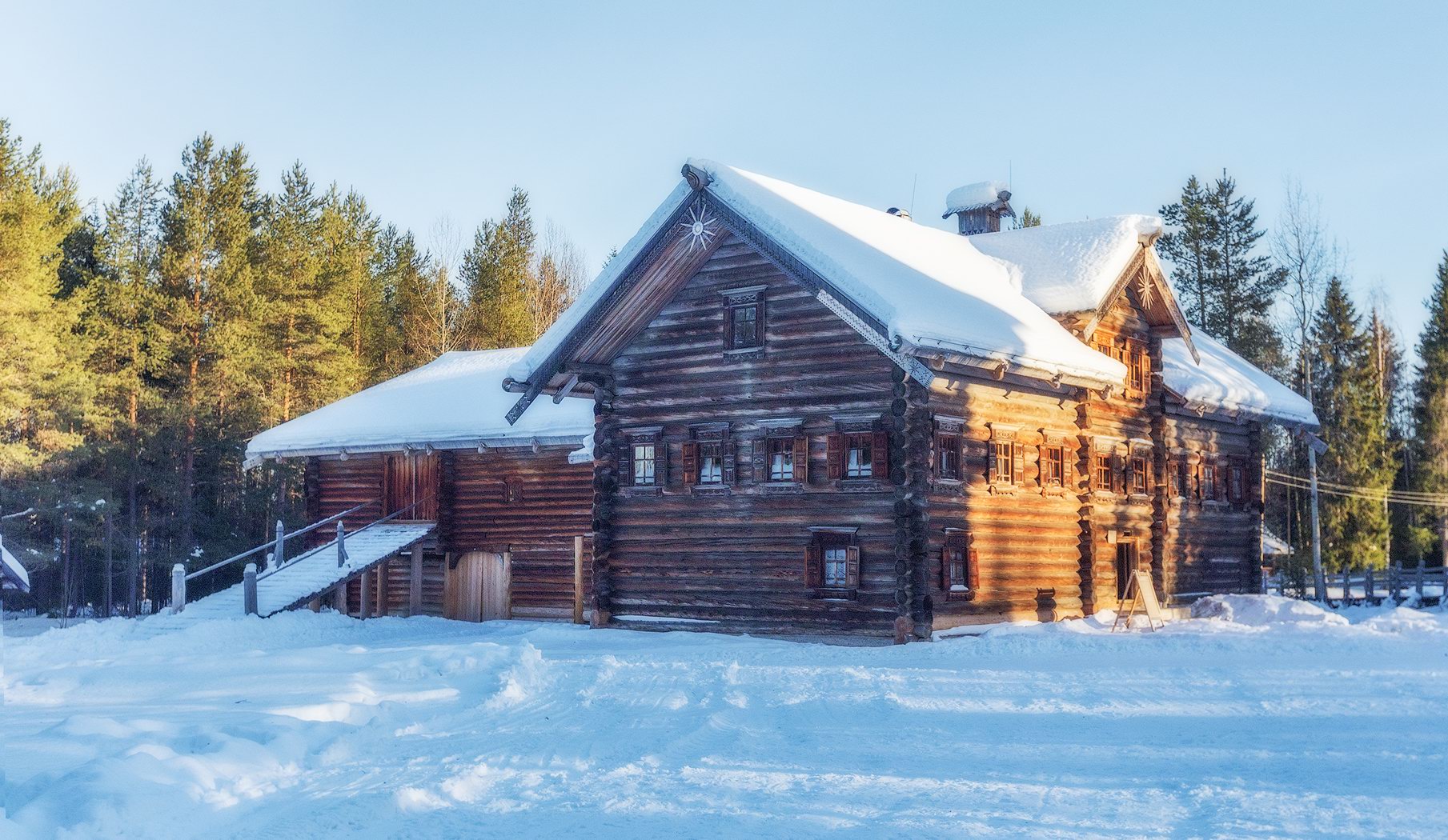
snow covered wooden architecture
Tags: Arkhangelsk oblast · museum
26
The Beauty of the Sofia Waterfalls in Karachay-Cherkessia
No comments · Posted by Sergei Rzhevsky in Nature, Regions, Travel
The Sofia Waterfalls are waterfalls of glacial origin flowing from the Sofia Glacier of Mount Sofia (3,637 meters) – one of the main natural attractions of the Arkhyz ski resort, located in the southern part of the Republic of Karachay-Cherkessia in the Western Caucasus.
These picturesque waterfalls are located approximately 15 km south of the village of Arkhyz. The Sofia Waterfalls reach their fullest flow in the height of summer (July and August), when the glacier is actively melting. The following photos were taken at the end of July by Fedor Lashkov. The Sofia Waterfalls on Google Maps.

Tags: Cherkessk city · Karachay-Cherkessia Republic · landscapes · Stavropol krai
29
The Granite Kingdom of the Ulakhan-Sis Range
No comments · Posted by Sergei Rzhevsky in Nature, Regions, Travel
A lot of people know about the picturesque remnant cliffs on the Manpupuner Plateau in the Northern Urals in the Republic of Komi.
However, in Russia, there is a number of similar places and one of them is the mountain range of the Ulakhan-Sis – a geological complex located in the polar part of Yakutia between the Indigirka and Alazeya rivers. The Ulakhan-Sis on Google Maps. Photos by: Sergei Karpukhin.

Tags: Sakha Republic · Yakutsk city
19
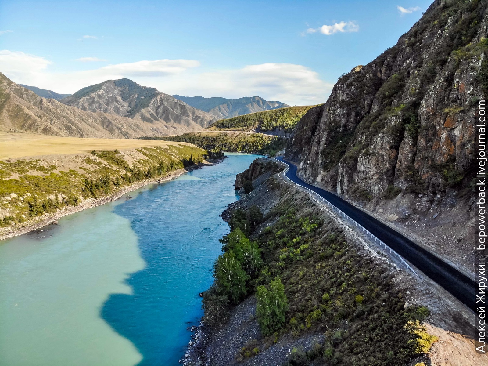
The Chuya Highway – the Most Picturesque Road in Russia
1 Comment · Posted by Sergei Rzhevsky in Photos, Regions, Travel
The federal highway R256 “Chuysky Trakt” (963 km), the oldest route from Siberia to Asia, starts in Novosibirsk and ends at the Russian border with Mongolia, passing through the territory of Novosibirsk Oblast, Altai Krai and the Altai Republic.
In 2014, National Geographic magazine included the Chuya Highway in its list of the 10 most beautiful highways in the world. Photos by: Alexey Zhirukhin.
Tags: Altai krai · Altay Republic · Biysk city · Novosibirsk oblast
12
Gorely – One of the Most Popular Volcanoes in Kamchatka
No comments · Posted by Sergei Rzhevsky in Nature, Regions, Travel
Gorely Volcano is an active volcano located about 70 km from Petropavlovsk-Kamchatsky in southern Kamchatka. This volcanic complex consists of 11 cones and 30 craters, some filled with lakes of acidic or fresh water. The volcano formed approximately 38-40 thousand years ago.
About 6,000 years ago, explosive eruptions with violent lava flows occurred here, but since the 15th century, the eruptions have become more moderate. The last recorded volcanic activity was in the summer of 2010. Gorely Volcano on Google Maps. Photos by: Slava Stepanov.
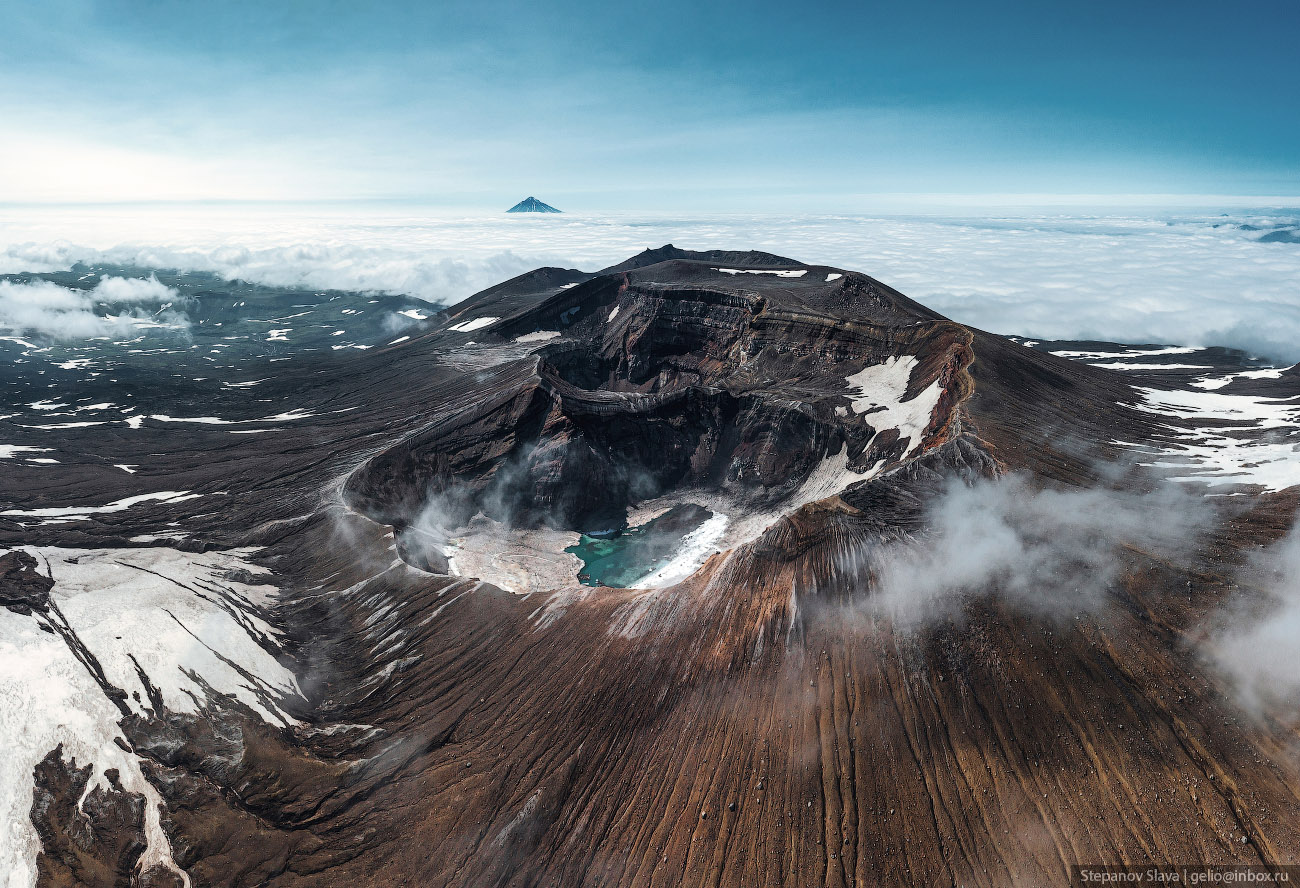
Tags: Kamchatka krai · Petropavlovsk-Kamchatsky city
12
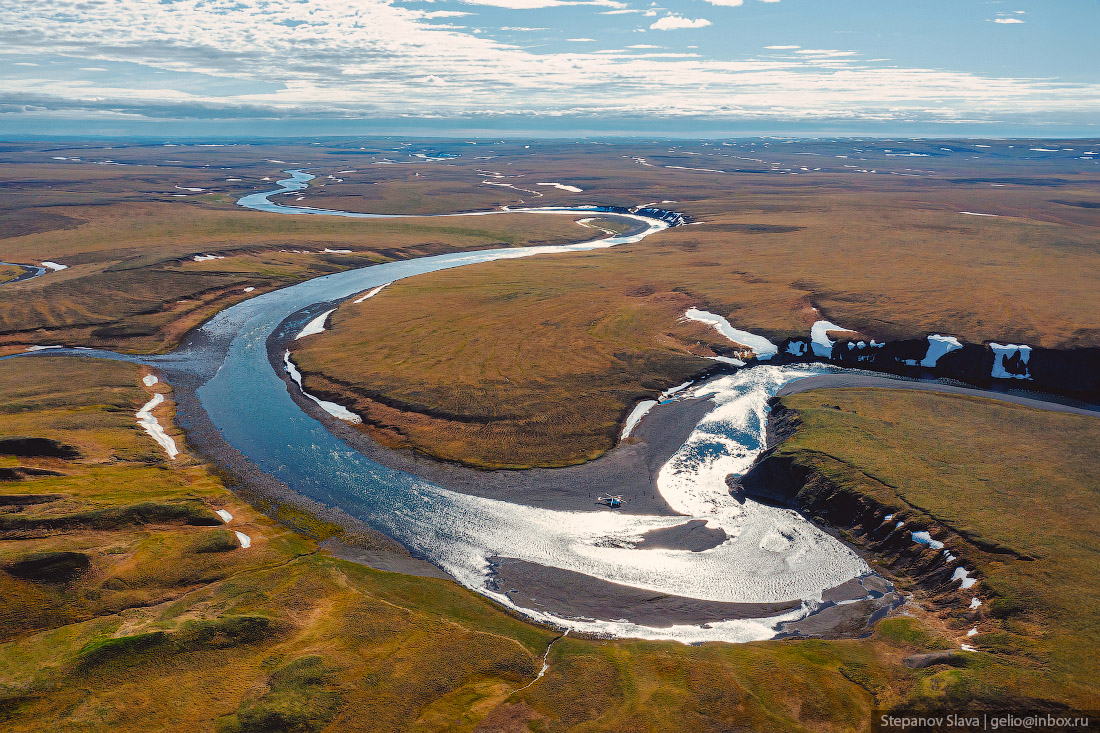
Taymyr – the Largest Peninsula in Russia
No comments · Posted by Sergei Rzhevsky in Nature, Regions, Travel
Taymyr, the largest peninsula in Russia and the northernmost continental landmass of the Eurasian continent, is located between the Kara Sea and the Laptev Sea, on the coast of the Arctic Ocean, in the very north of Krasnoyarsk Krai.
The total area of Taymyr is about 400 thousand square kilometers, which is larger than the area of such countries as Japan (373) and Germany (357). There are no cities on the peninsula, the nearest ones are Dudinka and Norilsk located to the south of the peninsula.
The Taymyr Peninsula is located in the Arctic and subarctic zones, which determines the extreme severity of its climate. Taymyr is characterized by long cold winters with temperatures down to -62 °C and short cool summers. Snowstorms are common, sometimes lasting up to several weeks. The local population is made up of peoples of the North who roam the territory. The Taymyr Peninsula on Google Maps. Photos by: Slava Stepanov.
Tags: Krasnoyarsk krai