History of Chita
Foundation of Chita
Since the Stone Age, the Mongoloid population lived on the territory of today’s Chita. In the Middle Ages, the Tungus lived here. The first Russian Cossacks, led by Pyotr Beketov, reached this area in 1653. It is considered the year of foundation of Chita, although it is not supported by archaeological evidence. The first documentary evidence about Chita dates back to the 1680s.
Since the end of the 17th century, this settlement was known successively as Chitinskoye plotbishche (obsolete Russian word meaning a place on the river bank where logs were tied into rafts), Chitinskaya sloboda, Chitinskiy fort, Chitisnkoye settlement, Chitinsk. In 1726, a post station was established. In 1762, the population of the settlement was 73 people. In 1776, the Church of St. Michael the Archangel was built in place of a church destroyed by fire.
In the early 1820s, there were 300 residents and 26 houses in Chitinsk. In the beginning of 1827, 85 Decembrists, participants in the uprising against autocracy on Senate Square in St. Petersburg (December 1825), were exiled to Chitinsk. During the 3.5 years of stay in Chitinsk, the Decembrists left a rich cultural heritage, including watercolors by Nikolai Bestuzhev.
These political prisoners had a great impact on the development of Chitinsk. In particular, it owes its geometric plan to the works of Peter Falenberg, who organized a topographic survey and created the basis for the Chitinsk development plan. A huge contribution to the formation of the town was made by Dmitry Zavalishin, who stayed in Chitinsk voluntarily even after the amnesty of 1856 - until his expulsion for criticizing the local authorities in 1863.
More historical facts…
Chita - one of the main cities in Siberia
In the middle of the 19th century, Chitinsk became one of the most important strongholds in the development of the Amur River region. In an effort to strengthen Transbaikalia and on the urgent recommendation of the Governor-General of Eastern Siberia Nikolai Muravyov-Amursky, Emperor Nicholas I created the Transbaikal Cossack army of six horse regiments with a military administrative center in Chitinsk.
In 1851, a separate Zabaykalsky (Trans-Baikal) Oblast was created in the Russian Empire, and Chita received the status of a town and became its center with a population of 659 people. After that, the rapid growth and development Chita began. In 1863, the population totaled 3,140 people, in 1897 - 11,848 people. Almost all the buildings in the town were wooden.
In 1891, Chita was visited by the heir to the throne - the future Emperor Nicholas II. In 1897, the Trans-Siberian Railway passed through Chita. The first train arrived in Chita in 1899. After that, in just five years, the population of the town grew from 16.5 thousand to 39 thousand people.
During the Russo-Japanese War of 1904-1905, Chita was a rear city where large military depots and hospitals were located. At this time, it was swept by revolutionary unrest. For two months, from November 22, 1905 to January 22, 1906, power in Chita actually belonged to the Socialist Council of Soldiers and Cossack Deputies, although legally remained with the military governor. In January 1906, the uprising was crushed by military force.
In 1907, there were 44 streets in Chita that bore names primarily related to the history of development and the geography of Siberia and the Far East. In 1910, the population of the city totaled 68,211 people. Chita became one of the leading cities in Siberia. During the First World War, prisoners of war of the German, Austro-Hungarian, and Ottoman armies were held in the city and at the nearest stations.
Chita in Soviet Russia and beyond
During the Civil War in the former Russian Empire, power in Chita changed several times. From September 6, 1918 until the end of July 1920, the troops of the Japanese Expeditionary Force were stationed in Chita.
In 1920-1922, Chita was the capital of the Far Eastern Republic with territory from the eastern coast of Lake Baikal to the Pacific Ocean. De jure, it was an independent state, de facto - a buffer state between Soviet Russia and Japan. On November 15, 1922, the republic was included in the Russian Soviet Federative Socialist Republic, as Far Eastern Oblast. The population of Chita in this period of time was about 60,000 people.
The late 1920s - early 1930s were marked by the massive closure of churches. In 1935, the Alexander Nevsky Cathedral was blown up. Since 1923, most of the streets in the city center were renamed after revolutionaries, participants in the Civil War, Soviet leaders. In 1937, Chita became the administrative center of Chita Oblast.
In 1939, Soviet soldiers wounded in battles with the Japanese on the Khalkhin Gol River in Mongolia were taken to local hospitals. During the Second World War, thousands of residents of Chita were drafted into the Soviet army. The position of Chita was determined by the fact that, on the one hand, it was in the rear, on the other, it was in close proximity to Manchuria, at the tip of a possible strike from the Japanese Kwantung army. That’s why large enterprises from the western regions of the USSR were not evacuated to Chita.
In August 1945, Chita was declared a front-line city in connection with the outbreak of hostilities of the USSR against Japan. Until 1949, there were Japanese prisoners of war in Chita who worked on the construction of buildings of the Trans-Baikal Railway Administration, a number of residential buildings, and other facilities.
In the early 1950s, asphalting of the city streets began. In the 1960s, a lot of multi-storey residential buildings were built. In 1968, the Chita worsted-cloth factory was commissioned - one of the largest in the USSR. The rapidly developing Chita became attractive to residents of other regions of the Soviet Union. From 1956 to 1986, the population of the city more than doubled - from 162 thousand to 347 thousand people.
In the second half of the 1980s, Chita, along with the whole country, began to fall into a crisis that dragged on until the beginning of the 21st century. In the 1990s, the city lost most of its industrial enterprises, the agricultural component of its economy, as well as more than 50 thousand residents. Private companies began to actively develop, which contributed to a sharp increase in crime.
The regional feature of the transition of Chita and Chita Oblast to a market economy was the proximity to China and rich forest reserves, the logging of which does not require highly skilled labor.
At the beginning of the 21st century, the situation began to improve. Housing construction intensified, foreign economic relations strengthened, and the infrastructure of the consumer market developed greatly. In 2008, Chita became the center of the newly formed Zabaykalsky Krai.
Architecture of Chita
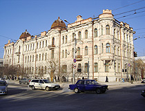
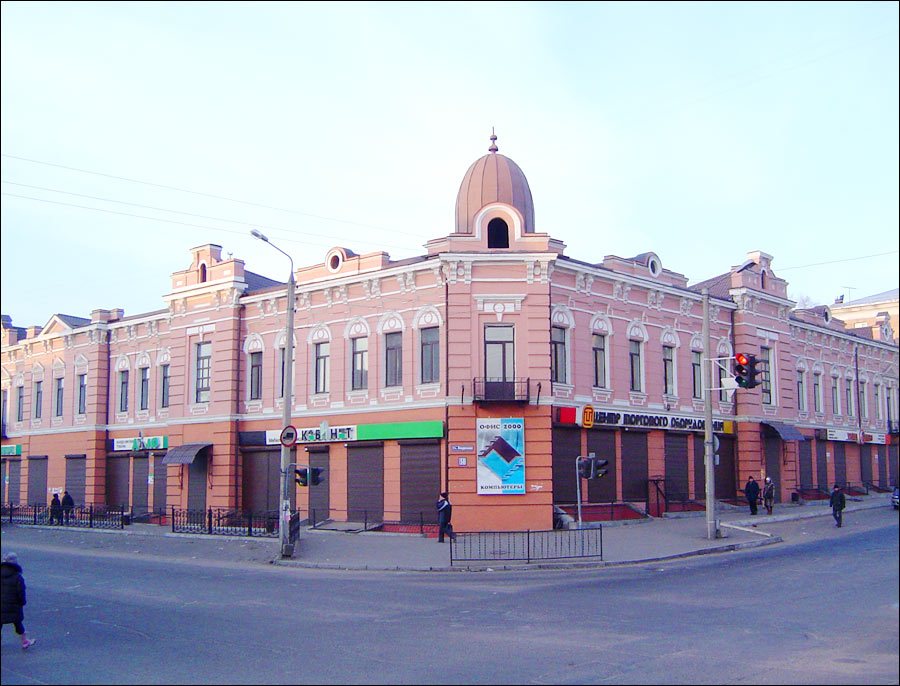
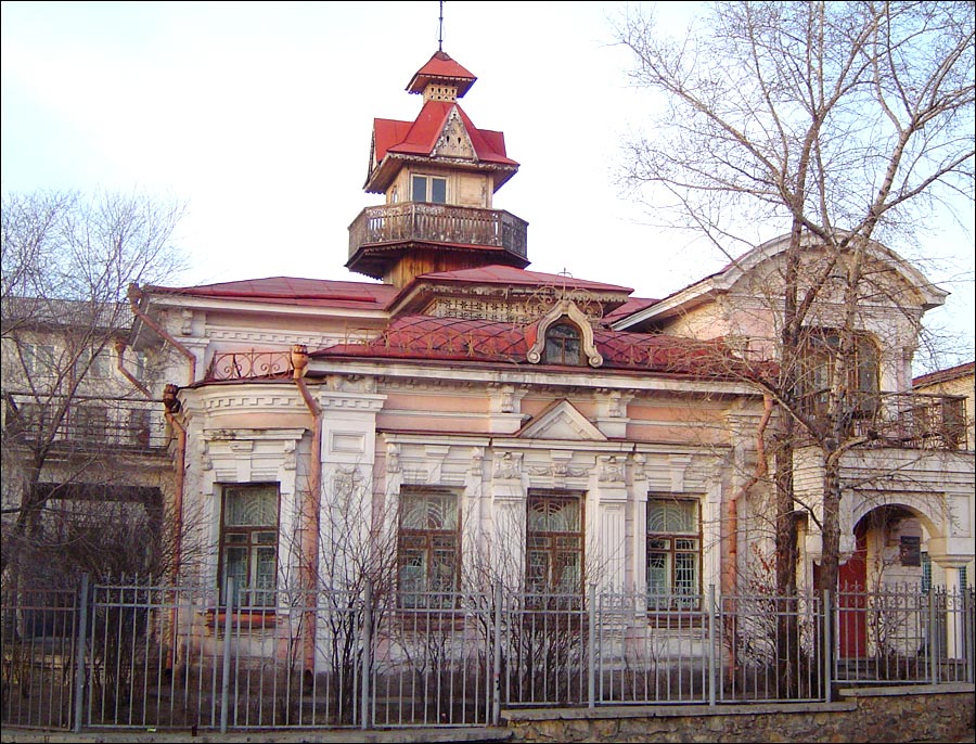
Shumovsky Palace in Chita
Author: Irina Kikavets
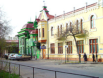
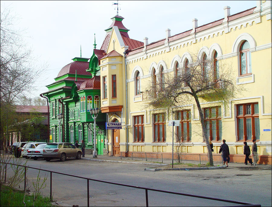
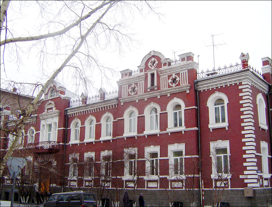
Pre-revolutionary architecture of Chita
Author: Evgeny Abramenko

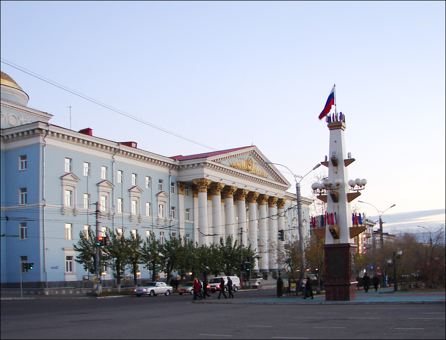
On the street in Chita
Author: Irina Kikavets
Chita - Features
The city is called Chita because it is located on the banks of the Chita (Chitinka) River. There are several versions of what the word “chita” means. According to the official version, it is a “river flowing from a wet place.” The City Day of Chita is celebrated on May 31.
The highest place in the city is Mount Chita (1,039 meters), the lowest - 632 meters. In the southwestern outskirts of the city there is Mount Titovskaya Sopka (780 m) - a natural-historical territory and a geological monument of nature.
The climate in Chita is sharply continental. It is also affected by the altitude of the city above sea level - an average of 650 meters. Winter in this city is very cold, with little snow, and long (about 5-6 months). The average January temperature is minus 23.9 degrees Celsius. Snow cover usually forms in late October and melts only in mid-April. Summer is warm and short (about 2.5 months). The average temperature in July is plus 19.6 degrees Celsius.
Chita is one of the sunniest cities in Russia (about 40% more hours with sunshine than in Moscow), similar to such southern cities of Russia as Anapa or Nakhodka.
The environmental situation is generally unfavorable. According to Rosstat, in 2015 and 2016, Chita ranked first in Russia in air pollution. This is largely due to the fact that the city ranks second in Russia after Vladivostok in the number of cars per capita.
Chita International Airport (Kadala) (IATA: HTA, ICAO: UIAA), located 18 km from the city center, is a federal airport, which offers regular flights to such cities as Moscow, Yekaterinburg, Irkutsk, Novosibirsk, St. Petersburg, Khabarovsk, Yakutsk, and several others.
Three federal highways pass through Chita: the federal highway R258 “Baikal” Irkutsk - Ulan-Ude - Chita, the federal highway R297 “Amur” Chita - Khabarovsk, the federal highway A350 Chita - Zabaikalsk - the border with China.
Chita is a major railway center on the Trans-Siberian Railway. Public transport includes trolleybuses, buses, and minibuses.
There are more than 400 objects of cultural heritage in Chita: monuments of history, archeology, architecture, urban planning, monumental art. The main group of monuments of architecture and urban planning of Chita belongs to the end of the 19th - the beginning of the 20th centuries.
Main Attractions of Chita
Church of St. Michael the Archangel (also known as the Church of the Decembrists). Built in 1776, this is the oldest building in Chita, a monument of wooden architecture of federal significance. Divine services in this church were held for one and a half centuries.
Soon after the revolutionary events of 1917, the church was closed and fell into decay. The situation changed in 1971, when the building was given to the museum of local lore. After the restoration, which lasted more than 10 years, museum exhibits devoted to life in exile of the participants in the December uprising of 1825 were placed in the former church. Dekabristov Street, 3b.
Shumovsky Palace. This is a very picturesque building that has the status of an architectural monument of federal significance, an architectural pearl not only of Chita, but of the whole region. It was constructed at the beginning of the 20th century for the Shumov brothers, who owned gold mines. The exterior of the palace is an example of a surprisingly harmonious combination of classicism and baroque. Lenina Street, 84.
Titovskaya Sopka - the main natural attraction of Chita, an extinct volcano, which reaches a maximum height of 950 meters above sea level. People began to settle on the slopes of this mountain since ancient times, as evidenced by numerous archaeological finds dating back to different eras, starting from the Stone Age.
There are several observation decks from which you can enjoy amazing panoramic views of Chita. On some rocks you can still see ancient petroglyphs and rock paintings. Also the Chapel of Alexander Nevsky is located here.
Zabaykalsky Museum of Local Lore named after Alexey Kuznetsov - one of the oldest museums in Siberia and the Far East of Russia. In total, over 190 thousand monuments of natural history, material and spiritual culture are presented in the museum collection.
It has unique collections of archeology and ethnography characterizing the ancient culture of the inhabitants of Transbaikalia, the economy, religion, art of the indigenous and Russian people. Babushkina Street, 113.
Museum and Exhibition Center of Zabaykalsky Krai. This museum has several interesting collections: “Painting by Artists of Siberia and the Far East of the 20th century”, “Art of Transbaikal Artists”, “Soviet Graphics of the 20th century”, “Bone Carving Art of the Northern Peoples”, “Jewelry Art of the Urals”, “National Art of Buryatia of the 19th-20th Centuries”, “Russian Folk Toys”, and others. Chkalova Street, 120a.
Chita Geological Museum. Here you can find over 20 thousand samples of various minerals occurring in Zabaykalsky Krai including rocks containing gold, silver, and precious stones. In addition, there are fossils dating back to ancient eras. The collection of art works made from semi-precious stones and precious metals is of particular interest. Gorky Street, 28.
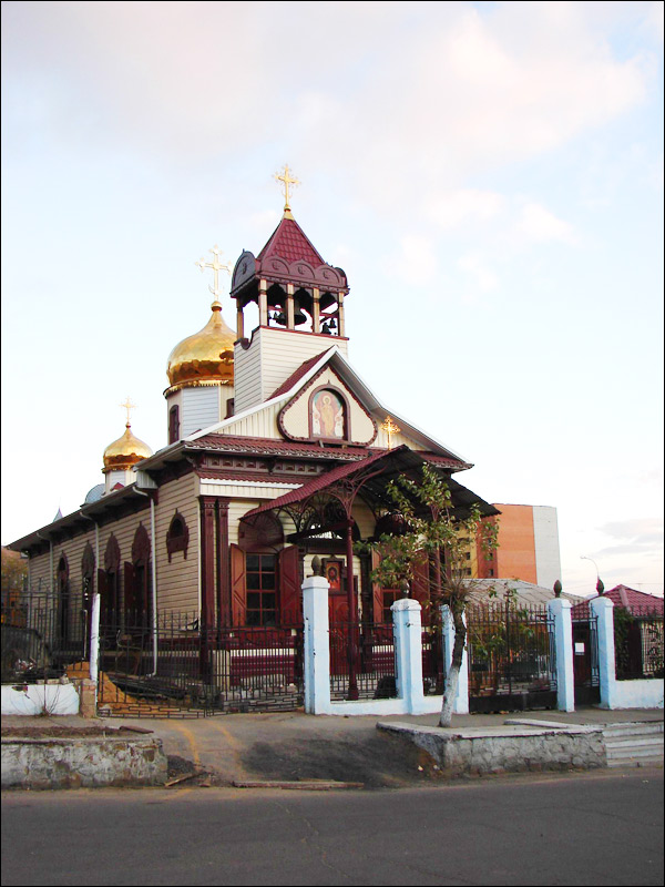
Kazan Cathedral (2004) - the main Orthodox church of Chita built in the Vladimir-Suzdal architectural style, sky-blue in color with contrasting white elements and gilded domes. It is one of the largest cathedrals in Siberia and the Far East. The maximum height of the building is about 47 meters. Butina Street, 6.
Chita Datsan “Damba Braybunling” (“the place where the rice of Buddha’s teachings is collected” in Tibetian). In 2010, a Buddhist university monastery was opened in Chita and immediately became one of the city’s iconic sights. During a tour of the datsan, travelers can see a two-meter statue of Shakyamuni Buddha, sculptures of lions traditional for Buddhist temples, and khurde drums used to perform prayers. Bogomyagkova Street, 72.
Chita Central Mosque (1907) - the only preserved pre-revolutionary mosque in Zabaykalsky Krai. The building is two-story, faced with red brick, with a high minaret. Anokhina, 3a.
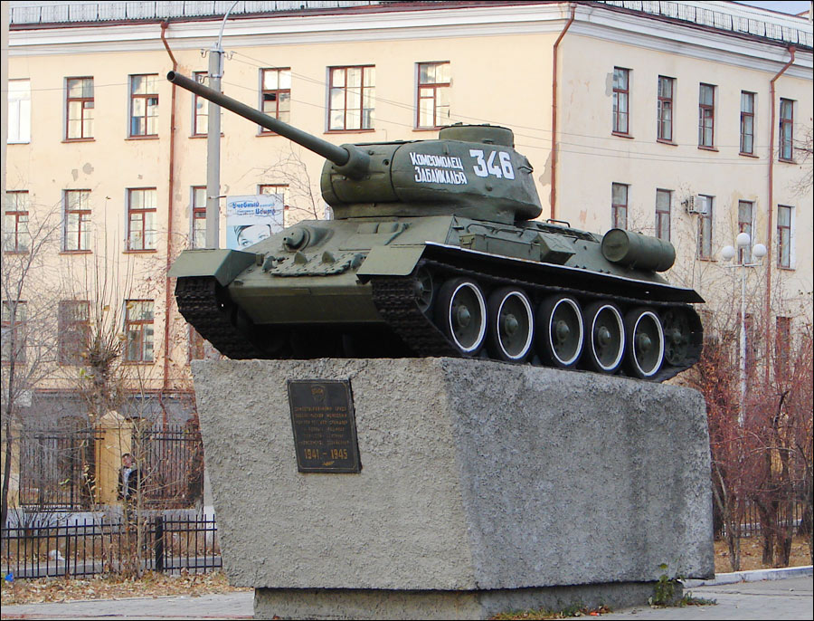
Odora Park - the oldest park in Chita located near its central square (Lenin Square). In a small area, you can find children’s rides, cafes, a lot of small architectural forms, an exhibition of military equipment, and playgrounds. Before entering the park you can admire the architecture of the Officers House (1938-1940). Lenina Street, 88a.
The Main Post Office of Chita (1893) - a unique monument of wooden architecture, the only historical building of Chita, which from the moment of its construction continues to be used for its original purpose. Butina Street, 37.