History of Syktyvkar
Foundation of Syktyvkar
Archaeological and written sources indicate that people began to settle in the territory of Syktyvkar and its environs relatively long ago. The settlements and camps of ancient hunters and fishermen repeatedly appeared in this area during the Neolithic, Bronze, Early Iron, and Middle Ages.
The history of today’s Syktyvkar began in the 16th century, when the Komi people settled in this area. They came here from the villages located higher along the Sysola River. The settlement of the area proceeded quickly facilitated by its convenient geographical position - at the confluence of two navigable rivers (the Vychegda and Sysola). This waterway connected the territory of the present Republic of Komi with Siberia and the Kama River region.
The settlement was first mentioned as Ust-Sysol (literally “the mouth of the Sysola River”) Pogost in 1586. It had the wooden church of St. George and 9 households, population - 48 people.
In the last third of the 17th and early 18th centuries, the rapid growth of the village of Ust-Sysola began. According to the census of 1720, there were 80 households with a population of 834 people here, within the boundaries of present Syktyvkar - 94 households with 1,006 residents. This growth is explained by a number of reasons, primarily the intensive settlement and agricultural development of the region of Ust-Sysola itself, the basin of the upper Vychegda River, and then the Pechora River. Ust-Sysola became an important center for transit and redistribution of goods.
In the middle of the 18th century, Ust-Sysola continued to grow and turned into a district center. Its development to a certain extent was facilitated by the construction of three iron foundries on the Sysola River in the 1750s-1760s.
More historical facts…
The town of Ust-Sysolsk
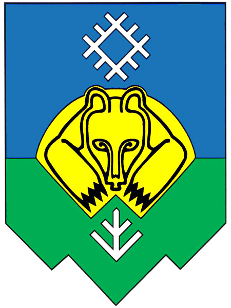
In 1780, Vologda Viceroyalty was formed with 19 districts, among which was Ust-Sysolsky district. In this regard, the village of Ust-Sysola was transformed into the district town of Ust-Sysolsk. At that time, there were 324 houses in the town, in which 1,727 people lived. In the same year, the coat of arms of Ust-Sysolsk was approved, which depicted a bear lying in its den (“as a sign that there are a lot of bears in the vicinity of this town”).
In the first half of the 19th century, contacts of town residents with other regions of the Russian Empire became closer. A great example of this is the participation of residents of Ust-Sysolsk in the events associated with the Patriotic War of 1812 (the French invasion of Russia). 53 soldiers were recruited in Ust-Sysolsk during the war.
In February 1814, a group of French prisoners - 100 people - came to the snow-covered Ust-Sysolsk. A lot of them were frostbitten and sick. A barracks and an infirmary were set up for them near the mouth of the Sysola River. After the end of the war, the French returned to their homeland, but the place where the French camp was located began to be called Paris.
In 1833, the town had 487 households, 4 churches, a religious school with 45 students, a hospital with 6 beds, 2,390 people. During the 19th century, Ust-Sysolsk turned into a large trade center in the Russian North. Trade routes from Pechora, Perm and Vyatka converged here. In 1858, 3,167 people lived here.
The district town of Ust-Sysolsk, located hundreds of kilometers from the regional center (Vologda) and the railways, grew slowly in the second half of the 19th century. However, due to its geographical position, as well as being the center of one of the largest districts in the Vologda Governorate, populated mainly by Komi-Zyryans, it increasingly became the center of the economic, political and cultural life of the Komi people.
In 1895, there were 772 wooden houses and 7 stone buildings in the town. In 1897, Ust-Sysolsk ranked fourth in terms of population among 12 towns in the Vologda Governorate - 4,464 people.
Syktyvkar in the 20th century
In 1913, the population of Ust-Sysolsk was 6,268 people. Out of 1004 towns of the Russian Empire, Ust-Sysolsk occupied the 690th place in terms of the number of residents. In terms of ethnic composition, 95% were Komi (Zyryans), the rest were Russians.
On August 22, 1921, Ust-Sysolsk became the administrative center of the newly formed Autonomous Oblast of Komi (Zyryans). After the transformation of Ust-Sysolsk into a regional center, the growth of the town’s population accelerated. In 1924, the regional authorities proposed to rename Ust-Sysolsk to “Vladimir Lenin”, but no decision was made. In 1926, the population of the town was 8,420 people (78.1% - Komi).
On March 26, 1930, in honor of the 150th anniversary of the city, Ust-Sysolsk was renamed Syktyvkar (in the Komi language it literally means “the town on the Sysola River”). In 1930, a timber mill, a printing house, a power plant, educational institutions with 1,667 students, medical institutions (173 beds), 17 trading establishments operated in it. On December 5, 1936, Syktyvkar became the capital of the Komi Autonomous Soviet Socialist Republic (today, the Komi Republic).
In January 1941, the population of Syktyvkar was 32.4 thousand. In 20 years, Syktyvkar from a small district town with a population mainly employed in agriculture and small handicrafts turned into an important industrial center of the region.
During the Second World War, from July 1941 to May 1945, 10,332 people were drafted into the Red Army in Syktyvkar, including 565 women. Most (80%) of those liable for military service went to the front in 1941-1942. By December 15, 1946, 2,099 demobilized soldiers and officers returned to Syktyvkar. During the war, Syktyvkar became a large center for the study of the European North. The Karelian-Finnish University was evacuated here from Petrozavodsk.
The needs of river transport, as well as the timber and woodworking industries, determined the post-war development of ship repair and shipbuilding in Syktyvkar. The development of the timber industry on the territory of the Komi ASSR required the creation of metalworking and mechanical engineering enterprises in this city.
In 1958, there were more than 100 streets in Syktyvkar, the length of which was over 45 kilometers. About 20 kilometers of roads were paved with asphalt and stone. The living area of the city increased from 137.8 thousand square meters in 1946 to 300.4 thousand square meters in 1955.
According to the population census (January 15, 1959), there were 64.5 thousand people in Syktyvkar. The census recorded the multinational composition of the city’s population. Komi accounted for 50.3%, Russians - 36%, Germans - 4.3%, Ukrainians - 4%. In the mid-1960s, the Syktyvkar timber industry complex became one of the largest enterprises in the country. Syktyvkar State University was opened on September 1, 1972.
A ski stadium was built in Syktyvkar. In March 1977 and 1979, the USSR cross-country skiing championship was held here. The Komi ASSR became an Olympic center for the training of skiers.
In February 1980, the XIII Winter Olympic Games were held in Lake Placid, New York, United States. Among those who represented the multinational Olympic team of the USSR were four strongest skiers from Syktyvkar - champions of the previous Olympics Raisa Smetanina and Nikolai Bazhukov, Vasily and Nina Rocheva. The first three became champions of the XIII Olympic Games. In 1989, the population of Syktyvkar was about 232 thousand people.
On May 26, 1992, Syktyvkar became the capital of the Komi Republic within the Russian Federation. In 1993, a new general plan of the city was adopted, a draft of a new coat of arms was approved, repeating the main element of the coat of arms of the times of the Russian Empire - a bear lying in a den.
Syktyvkar - Features
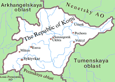
Syktyvkar is located in the southwestern part of the Komi Republic on the left bank of the Sysola River at its confluence with the Vychegda River. In the Komi language “Syktyv” means “Sysola”; “kar” - “town”. Thus, the name means “the town on the Sysola River”. The City Day of Syktyvkar is celebrated on June 12.
The climate of Syktyvkar is moderately continental, with short, cool summers and long, rather cold winters. Frosts are possible even in July, autumn and spring are cold and long. The average temperature in January is minus 14.2 degrees Celsius, sometimes the temperature drops to minus 35 degrees Celsius and even lower, in July - plus 17.5 degrees Celsius.
The Komi Republic has a fairly high level of internal migration. Residents of the Far North regions or disadvantaged villages go to Syktyvkar. For example, after studying, young people stay to work in Syktyvkar, without returning to their native villages, where there are few opportunities. Population growth is observed only in Syktyvkar. The city attracts not only residents of the republic, but also neighboring regions.
Syktyvkar is a multinational city. Representatives of more than 70 nationalities live here. According to the 2010 census, 66% of the population were Russians, 25.9% were Komi, 2.8 were Ukrainians.
This city is a social and business center of the Komi Republic. It is also an industrial center in the north of Russia. In total, the city has about 40 large industrial enterprises. The share of forestry, woodworking, and pulp and paper industries accounts for about 62% of all manufactured goods. In Syktyvkar, about 250,000 cubic meters of commercial timber, 180,000 cubic meters of sawn timber, 43,000 cubic meters of plywood, and more than 370,000 tonnes of paper are produced annually.
Today, Syktyvkar is connected with the rest of Russia by all types of transport (rail, water, auto, air). The city has an international airport “Syktyvkar”, from which regular flights are carried out to Moscow, St. Petersburg, Arkhangelsk, Vorkuta, Samara, Yekaterinburg, and a number of other destinations. The flight time from Moscow to Syktyvkar is about 2 hours, the train journey takes about 24 hours. The main intracity transport is buses.
Syktyvkar is also one of the largest scientific centers in the European North of Russia. There are about 30 specialized institutions in the city that carry out research and development work.
It is one of the greenest cities in Russia. More than 70% of the entire city territory is covered with vegetation. The best time to visit is winter, summer or early fall.
Main Attractions of Syktyvkar
Fire Tower (1907) - an unofficial symbol of Syktyvkar. This octagonal tower covered with a hipped dome and topped with a weather vane makes the building look like a small castle. At the beginning of the 20th century, it was the tallest building in Syktyvkar. It is located in the old part of the city; the main excursion routes lead to it.
The building is still used as a fire station. There is a small museum on the third floor. People come here mainly to listen to the anthem of Syktyvkar performed by the tower clock (every hour from 8:00 to 22:00). Sovetskaya Street, 9.
National Museum of the Komi Republic - the largest and oldest museum in the Komi Republic. Its expositions are devoted to the unique nature of Komi, traditions, way of life and customs of the Komi-Zyryans, eventful history of the region. The colorfully decorated exhibitions are arranged in chronological order starting from the Bronze Age.
The halls show the reconstruction of prehistoric camps, settlements, and villages. Among the exhibits you can see archaeological artifacts, national clothes, ancient tools, cult accessories, etc. Lenina Street, 57.
National Gallery of the Komi Republic - the largest collection of works of art of the 17th-21st centuries in the Komi Republic (about 10 thousand paintings, graphics, icons, and sculptures). Here you can see the works of indigenous, Russian, Soviet, and foreign masters. A collection of paintings by G. Lazarev, V. Roskin, K. Medunetsky is of particular interest for connoisseurs of avant-garde art.
The gallery building is an architectural monument. Near the building you can also visit the so-called “sculpture garden” with sculptures created by the Komi people, as well as people from Hungary, Finland, and other countries. Kirova Street, 44.
Museum of Olympic Champion Raisa Smetanina. The museum occupies a house presented by the republic to this famous Olympic champion. Smetanina was a member of the Soviet cross-country skiing team for 20 years. She participated in 5 Olympiads and returned with medals from all of them. The exposition tells not only about her biography, but also about the development of cross-country skiing, as well as about other athletes from Komi. Tentyukovskaya Street, 301.
Geological Museum named after A.A. Chernov. The museum is named after the discoverer of the Pechora coal basin. Almost all of its exhibits were found in the northeast of the European part of Russia: samples of fossil flora and fauna, minerals, ores of ferrous, non-ferrous and rare metals, fossil fuels. Pervomayskaya Street, 54.
Ivan Morozov’s House Museum. This museum was opened in honor of the local statesman Ivan Pavlovich Morozov in 2004. He was the leader of the Komi Republic for over 20 years. The museum occupies a picturesque wooden house built to recreate the atmosphere of the 20th century. The exposition includes original photographs and documents. The museum regularly hosts temporary exhibitions dedicated to prominent people of the Soviet era. Kirova Street, 32.
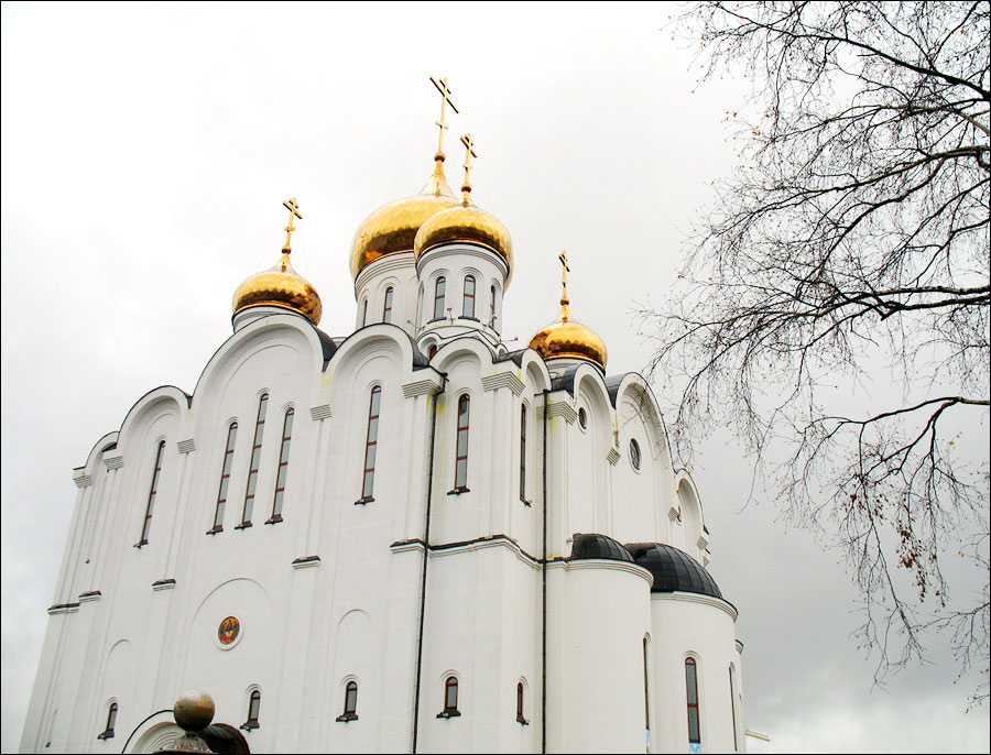
Cathedral of St. Stephen - the main Orthodox church in the Komi Republic dedicated to Saint Stephen of Perm, who converted local pagans to Christianity in the 14th century. In 1932, the church was completely dismantled. At the end of the 20th century, it was decided to restore it. This magnificent white-stone cathedral, the main dome of which rises to 64 m, was constructed in the best traditions of old Russian religious architecture and is very similar to the churches of Vladimir or Vologda. Svobody Street, 60.
Church of Christ the Savior (1995) - a majestic three-story red brick building, one of about a dozen religious sites in the Komi Republic belonging to the Evangelical denomination. Divine services are held on Sundays. They sing both in Russian and in the Komi language. Oktyabrskiy Avenue, 35.
Park of Culture and Rest named after S.M. Kirov - the largest recreational area of Syktyvkar located on the bank of the Sysola River. The park was officially opened on June 18, 1934, although a small public garden in this place had been laid back in 1890. In 2016, a complete reconstruction of the park was carried out. In the warm season, there is a rental of bicycles, gyro scooters, scooters. There are several playgrounds. Kirova Street.
Finno-Ugric Ethnocultural Park - a multifunctional tourist complex dedicated to the cultural heritage of Finno-Ugric and Samoyedic peoples. Here you can learn more about the culture and traditions of the Finno-Ugric peoples. The park is located in the village of Yb, close to the federal highway Kirov-Syktyvkar, about 60 km south of Syktyvkar.


The comments of our visitors