
CAT | Nature
13
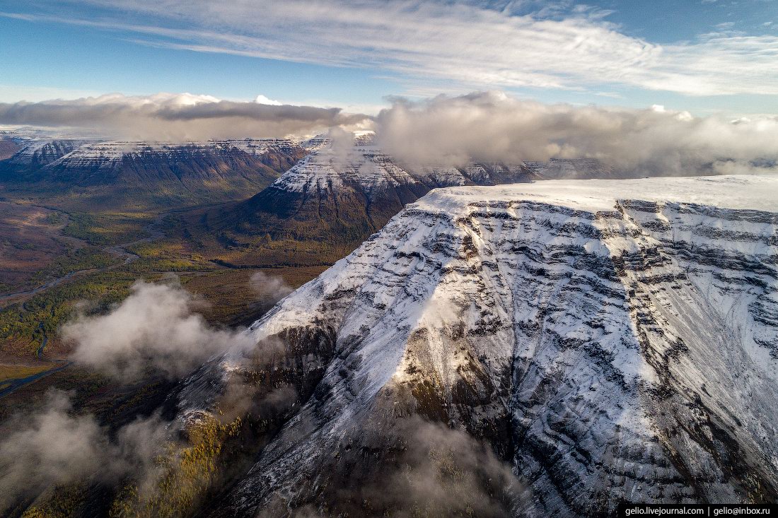
Putorana Plateau – the Mountains with Flat Tops
No comments · Posted by Sergei Rzhevsky in Nature, Regions, Travel
Putorana is a strongly dissected mountain range located in the northwest of Krasnoyarsk Krai. The nearest large settlement is the city of Norilsk. The surface of the plateau is covered with basaltic lava flows often referred to as the Siberian Traps. This is one of the most poorly studied and inaccessible regions of Russia.
The maximum height of the plateau is 1,701 meters. The name “Putorana”, translated from Evenki, means “lakes with steep banks”. The plateau area is about 250,000 square kilometers. The Putoransky Nature Reserve, recognized by UNESCO as a World Heritage Site, is located on the plateau. The Putorana Plateau on Google Maps. Photos by: Slava Stepanov.

Tags: Krasnoyarsk krai · Norilsk city
6
The Beauty of Sofia Falls in Karachay-Cherkessia
No comments · Posted by Sergei Rzhevsky in Nature, Regions, Travel
Sofia Falls are waterfalls of glacial origin flowing from the Sofia Glacier of Mount Sofia (3,637 meters) – one of the main natural attractions of the Arkhyz ski resort located in the southern part of the Republic of Karachay-Cherkessia in the Western Caucasus.
These picturesque waterfalls are located about 15 km south of the village of Arkhyz. Sofia Falls become the most full-flowing at the height of summer (July, August), when the glacier is actively melting. The following photos were taken in late July by Fedor Lashkov. Sofia Falls on Google Maps.

Tags: Cherkessk city · Karachay-Cherkessia Republic · landscapes
27
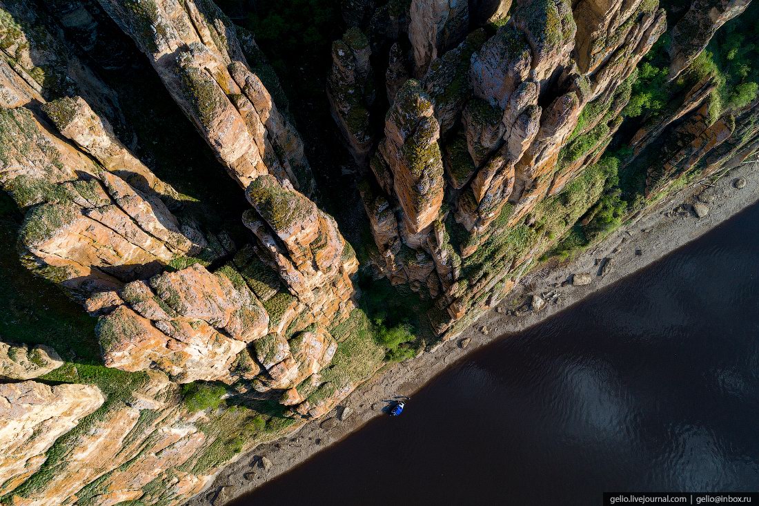
The Granite Kingdom of the Ulakhan-Sis Range
No comments · Posted by Sergei Rzhevsky in Nature, Regions, Travel
A lot of people know about the picturesque remnant cliffs on the Manpupuner Plateau in the Northern Urals in the Republic of Komi.
However, in Russia, there is a number of similar places and one of them is the mountain range of the Ulakhan-Sis – a geological complex located in the polar part of Yakutia between the Indigirka and Alazeya rivers. The Ulakhan-Sis on Google Maps. Photos by: Sergei Karpukhin.

Tags: Sakha Republic · Yakutsk city
21
Lena Pillars – the view from above
2 Comments · Posted by Sergei Rzhevsky in Nature, Regions, Travel
“Lena Pillars” is a geological formation and a national park located on the banks of the Lena River in the Republic of Sakha (Yakutia), about 170 km south-west of Yakutsk. Lena Pillars are a complex of vertically elongated rocks up to 220 meters high stretching for many kilometers along the Lena River bank.
In 2012, this natural monument received the status of a UNESCO World Heritage Site. In the language of the locals, the pillars are called “Turuuk Hayalara” (“Mountains of Rising Gods”). The main objective of the park is the development of ecological tourism. Lena Pillars on Google Maps. Photos by: Slava Stepanov.
fly over magnificent stone pillars
Tags: Sakha Republic · Yakutsk city
6
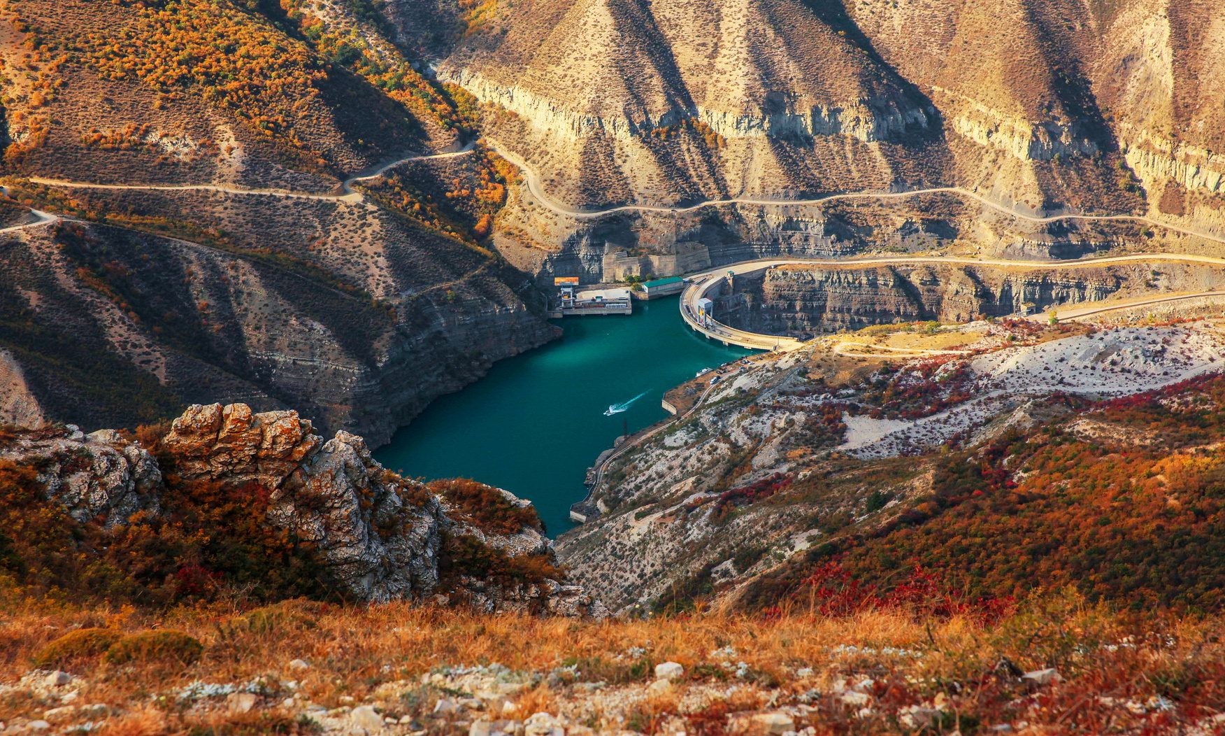
Sulak Canyon – the Deepest Canyon in Europe
No comments · Posted by Sergei Rzhevsky in Nature, Regions, Travel
Sulak Canyon, one of the most picturesque natural sights of the Republic of Dagestan, is the deepest canyon in Europe and one of the deepest in the world. The length of the canyon is 53 kilometers, the depth reaches 1,920 meters, which is about 60 meters deeper than the famous Grand Canyon in the US.
This is one of the most visited tourist sites in Dagestan. However, it is also one of the most dangerous places: high cliffs, sharp rocks, strong winds, the absence of any railings along the canyon. Sulak Canyon on Google Maps. Photos by: Murad Magomedov.
Tags: Dagestan Republic · Makhachkala city
9
Colorful Dawn on the Top of the Aygir Cliffs
No comments · Posted by Sergei Rzhevsky in Nature, Regions, Travel
Aygir is a small village located in the mountains of the Southern Urals in the Republic of Bashkiria, about 190 km southeast of Ufa. This area, one of the most inaccessible sights of Bashkiria, is very popular with tourists going to conquer the Ural peaks with backpacks on their shoulders.
From here you can enjoy picturesque views of Mount Maly Yamantau and the rocky peak of the Karatash Range. Aygir on Google Maps. Photos by: Vladimir Lyapin.

Tags: Bashkortostan Republic · Ufa city
18
Colorful summer sunset in the Volga River delta
No comments · Posted by Sergei Rzhevsky in Nature, Photos, Regions
These picturesque photos were taken on one hot summer evening in the Volga River delta somewhere in the Astrakhan region. The delta of the Volga is the largest river delta in Europe and the 8th in the world.
Due to the lowering of the level of the Caspian Sea, the delta area has increased ninefold over the past 130 years. The unique flora and fauna of the delta (sturgeon, lotus, flamingo, Siberian cranes, pelicans) are under state protection as the Astrakhan Nature Reserve. Photos by: Fedor Lashkov.

Tags: Astrakhan oblast
25
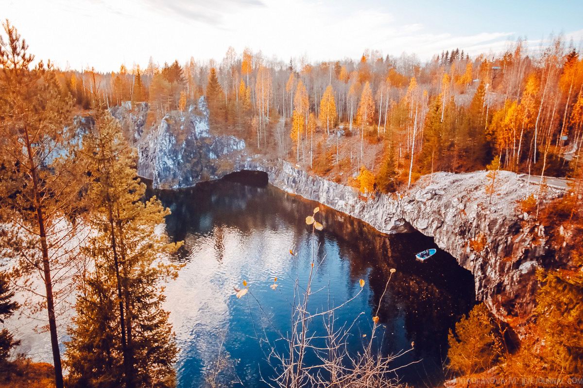
Autumn in the Ruskeala Mountain Park
No comments · Posted by Sergei Rzhevsky in Nature, Regions, Travel
The mountain park “Ruskeala” is a tourist complex located in the Sortavala district of the Republic of Karelia, near the border with Finland. The basis of the complex is an abandoned marble quarry filled with groundwater – a cultural heritage site and historic monument.
The park is located near the village of Ruskeala, about 30 kilometers north of the town of Sortavala. The length of the former marble quarry from north to south is 460 meters, the width – up to 100 meters. Ruskeala Park on Google Maps. Photos by: Maria Mitrofanova.
Tags: Abandoned · Karelia Republic · Petrozavodsk city
20
Magnificent Scenery of Ayskiye Pritesy
No comments · Posted by Sergei Rzhevsky in Nature, Regions, Travel
Ayskiye Pritesy is a unique natural geological object – high limestone cliffs located on the section of the Ay River on the border of the Chelyabinsk region and the Republic of Bashkortostan.
These limestone rocks, picturesque vertical walls up to 90 meters high, consist of two groups – Bolshiye (Large) Pritesy and Malyye (Small) Pritesy. In the local dialect, Ayskiye Pritesy are called “Sybar-kaya”, which in Bashkir language means “varicoloured cliff”. Ayskiye Pritesy on Google Maps. Photos by: Vladimir Lyapin.
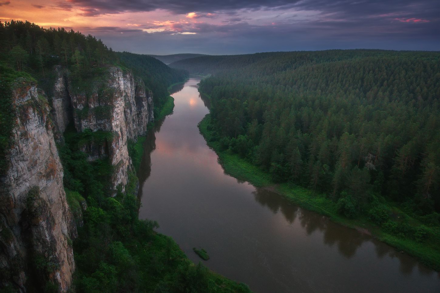
amazing natural monument of the Southern Urals
Tags: Bashkortostan Republic · Chelyabinsk oblast
11
Amazing Landscapes of Kamchatka
No comments · Posted by Sergei Rzhevsky in Nature, Regions, Travel
Kamchatka is a peninsula stretching from north to south for about 1,200 km in the northeast of Eurasia. From the west it is washed by the Sea of Okhotsk, from the east – by the Bering Sea and the Pacific Ocean. Kamchatka Krai, one of the federal subjects of Russia, is located on the territory of the peninsula.
Kamchatka is a land of contrasts, which looks completely different from Central Russia. This is the land of volcanoes and glaciers, hot springs and boiling geysers, fast-flowing rivers, lakes and waterfalls. There are 414 glaciers and 160 volcanoes, 29 of which are active. Kamchatka volcanoes are included in the UNESCO World Heritage. Photos by: Sergey Makurin.

Tags: Kamchatka krai